miklcct
On Moderation

The sign says "British Rail". How old is this sign?
Probably 30 years old.
and signs for Bristol at Clapham Junction platformI Believe there is still something similar at Greenford pointing passengers towards the bay platform for the West Ealing Shuttle...
 imgur.com

It did with Stratford and Liverpool Street too until the 2000s, as they were still doing "This is Stratford, Change for Docklands Light Railway and Network SouthEast services" until the milenium if i recall correctly, same with Liverpool Street which prevailed as "This is Liverpool St, Change for Metropolitan, Hammersmith & City and Circle Lines, Network SouthEast and Intercity Services" for many a year post privatisation.Vauxhall LU, I believe? Interesting that a sign has been out of date for so long that it has now with GBR become correct again!
Semi-related, the Central line "sonya" announcements still referred to changing for Network Southeast (the Waterloo & City) services at Bank for years after the transfer to LUL, up until their next refurbishment.
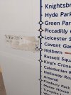
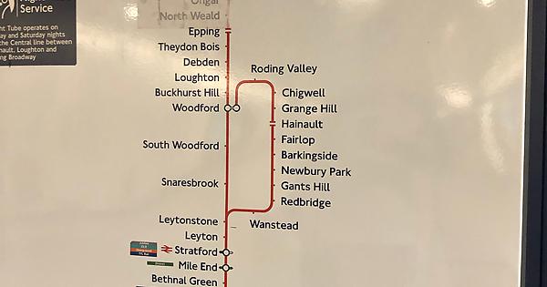
I think there is a map at Newbury Park which still has the Epping to Ongar branch covered up behind a sticker. Most of Central Line has been updated with stickers cos its cheaper than full maps, as im sure once Bond Street Crossrail platforms opens they will just update the carriage maps with a small sticker rather than using new maps given it makes more sense less hassle and is far cheaper to do,There are a lot of old maps around, especially in Central London tube stations - the large map on the curved track wall. I can't remember where, but I remembered seeing the old 1980s DLR logo on one of the maps, and of course a lot of BR (Bank W&C platforms have the 1990s DLR logo). I remember some maps still refer to the H&C as the Met.
Liverpool Street Central Line has a map at the bottom of the escalators with Epping - Ongar covered up.
Edit: after checking some online photos, the Liverpool Street Central Line map is the one with the 1980s DLR logo.
Old Central line map
Discover the magic of the internet at Imgur, a community powered entertainment destination. Lift your spirits with funny jokes, trending memes, entertaining gifs, inspiring stories, viral videos, and so much more from users like Platform2B.
Edit 2: which... no longer exists at Liverpool Street.... Probably removed when Crossrail opened.
Epping Ongar Extension Central Line Diagram (052022)
Grade B 112 x 173 x 4cm Vitreous enamel sign with scratching throughout but no damaged to text. We are unsure of the exact date of this sign but it pre-dates 1994 as it includes the Epping to Ongar extension of the Central line. This extension was closed by London Underground in 1994 and...www.ltmuseumshop.co.uk
There’s loads of old and out of date signage or evidence of signage around the network. The down fast SWML still shows Penzance, Plymouth and other west of Exeter stations on the list at the top of the staircase that SWT stopped serving since before they became SWR.and signs for Bristol at Clapham Junction platform
There appears to have been a change of policy of late whereby entire new car line diagrams are being produced rather than individual stickers that go over stations or groups of stations, even for relatively short-term things, such as the Bank blockade on the Northern line earlier this year, and on the Jubilee and Central lines where Crossrail interchange at Bond Street is shown as crossed through.Most of Central Line has been updated with stickers cos its cheaper than full maps, as im sure once Bond Street Crossrail platforms opens they will just update the carriage maps with a small sticker rather than using new maps given it makes more sense less hassle and is far cheaper to do,
Similarly, the Aldwych branch is visible on the Piccadilly line map on the eastbound platform at Baron's Court, as the presumably 28-year old sticker is peeling off.I think there is a map at Newbury Park which still has the Epping to Ongar branch covered up behind a sticker. Most of Central Line has been updated with stickers cos its cheaper than full maps, as im sure once Bond Street Crossrail platforms opens they will just update the carriage maps with a small sticker rather than using new maps given it makes more sense less hassle and is far cheaper to do,
Maybe it would have been better to produce the "final" Central Line map showing the interchange at Bond Street. Then cover it with a sticker for the time being. When the Bond Street interchange eventually opens, peel off the sticker to reveal the clean final map.There appears to have been a change of policy of late whereby entire new car line diagrams are being produced rather than individual stickers that go over stations or groups of stations, even for relatively short-term things, such as the Bank blockade on the Northern line earlier this year, and on the Jubilee and Central lines where Crossrail interchange at Bond Street is shown as crossed through.
Is it still there ? I've not noticed myself, is there a photo ?Similarly, the Aldwych branch is visible on the Piccadilly line map on the eastbound platform at Baron's Court, as the presumably 28-year old sticker is peeling off.
"Barely visible" would admittedly be more accurate, but you can definitely see it at leastIs it still there ? I've not noticed myself, is there a photo ?