• Our booking engine at tickets.railforums.co.uk (powered by TrainSplit) helps support the running of the forum with every ticket purchase! Find out more and ask any questions/give us feedback in this thread!

Crossrail 2 on the Tube Map

Status
Not open for further replies.

Ali.Carr

Member
Joined
17 Feb 2018
Messages
44
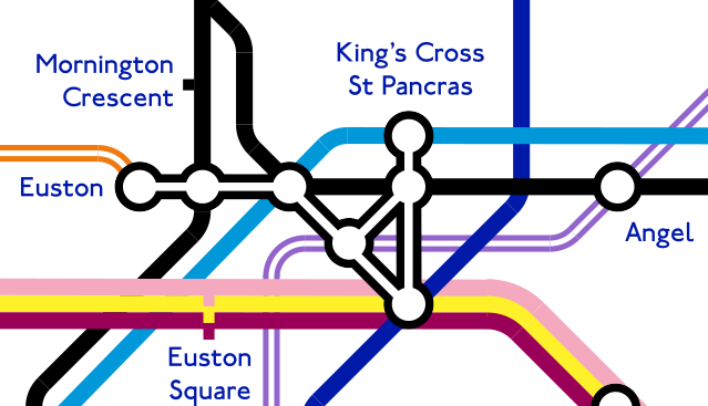
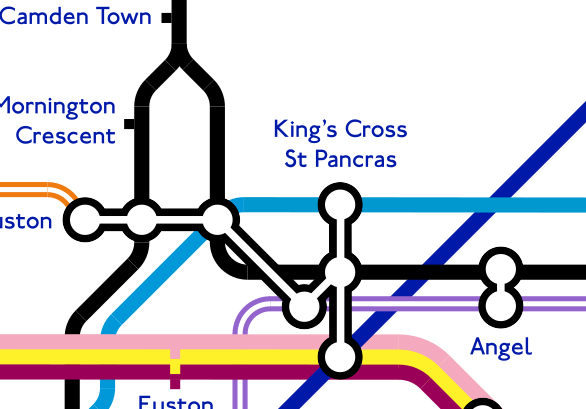
I had a go at putting Crossrail 2 onto the Tube Map. It's split into three sections, which you can see below:
QPH9uX2AXXdHoHSYcMoJiF-dJ0kkZTWcXjDhhsQYIAmp7134Qdv3Zkvc4dlKcQ_V-rj2GyygeIX8NGa5w21lzyRQzJg2pD7xo7nMI0FKv_fm4MJB3zamXO0RPLJyDWFjPTYm-IAJvafbyUiJWLHj71SuFHvNo32es_ITSWujpue21l8JtgU5Ycop9yIVjIg4Rb-zHEZTtusT78ztTSx-nimGrnoiKUy3X-BSTtTpzsp86p9LiBXH8bExxnyeG9CZ2yOTdp9pcWbT5GzgGVMd8rkrlK4lnylBDqg2h3hnwDLodvopedlEud5wLpnVJYAu5YMln9zBafXQ7yh_W3RJbM7Pemu0ep2KY2a6ZzA9qs-GTlOWUQLwYee9Q2jSA6xAeFY3p5iul7inOycTuCAjXyf_I0RKea8Te4I0nSE-yIanbQngIZXhLbOuUFCLiB_VT-4_MzP5sifPjdK_OK1tiptvoUJO2zrY3-dPlXLIPJk7oxMUtd4QfwIUZUAvaJa-3KuQtN1bZUwSc5ey25102TpbHxS98BQLsHe-iho-yPDEwqtNsTTG5ktsKO4T3oUeze51GgtYuY_ATAFovLybAkRNdNLfMx0JkuLd0byaOOdMLF_TgfeetcBz8iefzlKPdlCy-loeQJUA8qVxDM0RJmOv7SOItnYY=w1335-h921-no
GelHNc8vKy6C3lAoT6ipVITWlDr5D__CD4RM_O22uTKBOkjuQ-jmNYPtEue5dQytXmHAHD4XvbzSOav8vUigWsd7TjZStFmJCg68lZQn79_QqjHg7rm3VGcPJclx8GUNO80_XbTIMqfAKMx74QQGf3sP7ijrd9yBckgCgcbQP17RUHRO9UgXiKqR7NPE6i9BPCWeTz7ahrx3rn61_i3wMemI3cV7Tz3wSjEH_BNI2CSNBuwbBs54P5nxrI-YhwLyQZBI0XDY49JS9ccXJocN4TO2yBovqrLp61l01JDI7Cjiin_bSeS8kqrK5hBgHZS43bP6BGv8CoHQ0dUlhRvuMB1YIKZgZZcht5qZR6khH8FUUm_HsBY0M7y7aCYMeyVmuhnKY2dddHxW7xPQoGCdcdJa_Fn-W-KgXw67tkCiIJSlzfhRx9nW0wL0E9nIVNKcw0RLRlxyMGPJItA55rmu5-8M_kOiv3GabrpMAxWMkf06yubD05nkXx9IE6CjpWuhuIk01Waytt8IvRwDFUlxptxo2eNOKjxSR9g4Z-nsNjRoUOVDiZXMVgTj35bKyBBLoTkJq81pw6Xxx-qyy8nnlCzY_MwZddn74Kz0cDU-5mTBPIMCaSxi2pOyGKu3S1y3i1BMBNR2rxeqcteQRjaHnYulIPNBSuMI=w794-h921-no
i0fg5tB1sD4xbWlhFaUFzRaweday8lBy9WL3CUMqigl85KOfetoRirUElBznwQDGodHtgk5kVCZ4GkprVsbCQaMSygpgHVBxa98GmSID__RbFKM2l4tMPH2y2lYfCHW1JX7JmQkGv9nzMWSQNPMOotXT3j37SHZIF5yeW9ditgs7kXzcLA3w-elDcuL69uAeXj3tOJRo650JVSh6wPlNU7cIDuV45TPMoqZXbn7NTHBgizBvF21-3IFXBD75BS57h_bPJW9nCVQp1JnGnjLGYjg4RKUQzrwdeGXKbDkhfreOSCQ5vY3s_kIJ3GhVAdt5KrCjpGyE5_BCikbag8YOOLuo_Efzqqn0ZpNtotXgWk-Wg4vtZD6yc-kWx0LZzQzwgXOd4fV4TMtP1B5ZFZRnSXlyJ4jxs6F3zB1QdNXrpuGdlbhB1Fq7XEKsM9p2wbYjFmqJEPwTr-5XcuvmrWN-3Jc5O5VYhLMz-lDK4z0NS0MOAdv9yyrzMXaFPlQZVnjTctetNopqGum79Qq9JcHbJklkvbdDLIzXkohe48yInanPrGerpUk684AbjmxjEGVEsmWFeRhwWFw0i6UT1v53T6E4Y8JBdL3eWVJXXXXCr6b6nmXOdxmTgMcVnaBJ0q0wF9G8KY8k29sBLIBS8kFTbhyH9YUnzD0X=w736-h921-no
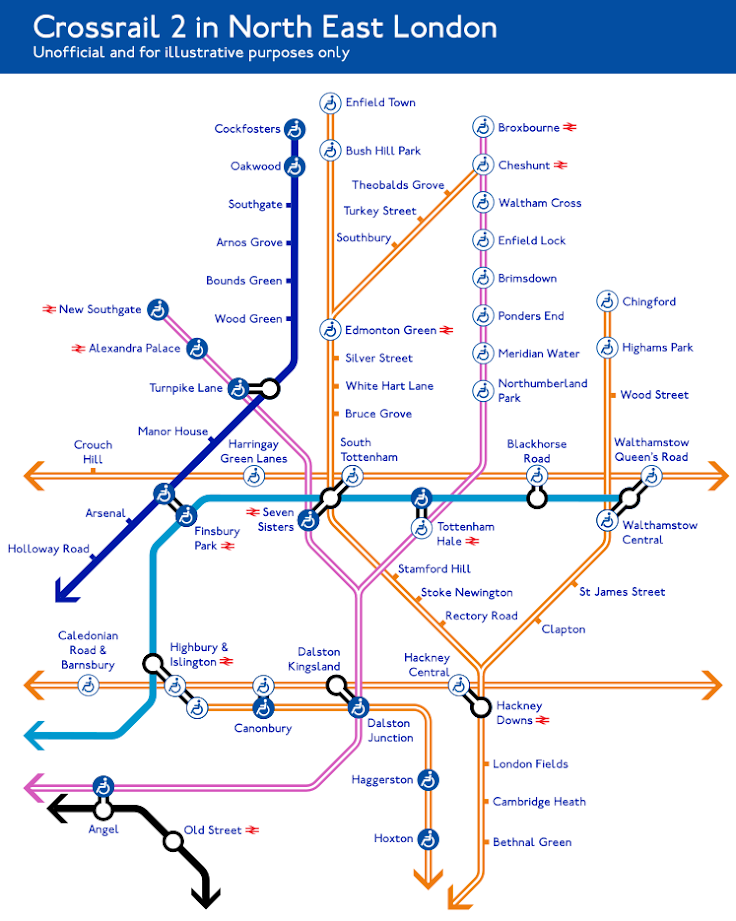
The maps are quite messy (the Overground in NE London is already spaghetti), and there are almost definitely errors. The likelihood of CR2 happening at all is quite low, let alone it having the route from the 2015 consultation. Even if it did, the rest of the Tube map would probably change unrecognisably as well by the time it's open (given how much the Overground has expanded in the last decade).

In spite of all these caveats, I thought it'd be quite cool to see CR2 in context. What do you think?


Edit: Subsequent to all of this, I made a full Tube map with CR2 (and some other stuff) on it, which found its way into the Evening Standard!
 
Last edited:
Sponsor Post - registered members do not see these adverts; click here to register, or click here to log in
R

RailUK Forums

Class 170101

Established Member
Joined
1 Mar 2014
Messages
7,942
Should Blackhorse Road not be a white wheelchair for London Overground as well? I believe its having lifts installed.

Also are we sure that an interchange is being provided at Turnpike Lane? I don't recall one being provided.
 
Last edited by a moderator:

Cowley

Forum Staff
Staff Member
Global Moderator
Joined
15 Apr 2016
Messages
15,786
Location
Devon
That’s excellent Ali. Thanks for posting it and welcome to the forum too.
 

Ali.Carr

Member
Joined
17 Feb 2018
Messages
44
Should Blackhorse Road not be a white wheelchair for London Overground as well? I believe its having lifts installed.

Also are we sure that an interchange is being provided at Turnpike Lane? I don't recall one being provided.

I don't know about the step-free access (I'm sure that that is where most of the errors are).

The interchange at Turnpike lane is based on this factsheet (http://crossrail2.co.uk/wp-content/uploads/2016/10/Wood-Green.pdf) which does refer to a Turnpike Lane interchange. I didn't map the Wood Green option, which looks like it was slightly less favoured after the 2015 consultation.
 

Class 170101

Established Member
Joined
1 Mar 2014
Messages
7,942
Something tells me Turnpike Lane has been added tothe route via Alexandra Palace since I looked last year.
 

Ianno87

Veteran Member
Joined
3 May 2015
Messages
15,215
Good map!

Notice you've just labelled "Dalston". That is the indeed the proposed name for the CR2 station (which will have interchange to Junction at one end and Kingsland at the other) - but don't believe there is currently any proposal to rename the existing stations.
 

The Ham

Established Member
Joined
6 Jul 2012
Messages
10,326
A good map, Euston/Kings Cross/St. P. Station looks like it could do with being different to improve how it looks. However what that would need to look like I don't know, or even if it is possible.
 

IainG81

Member
Joined
19 Mar 2017
Messages
74
It does pose the question in my mind why not just add on all National Rail stops inside the area. Places like Earlsfield and Hornsey just disappear. By that point when so many stations are included why leave of the few remaining?
 

Malcolmffc

Member
Joined
19 Mar 2017
Messages
300
Bond Street and TCR should just have a blue wheelchair blob. The white blobs are due to the 92 stock not being fully accessible but these will have been replaced by the time CR2 opens.

It’s also clear that TfL is going to have to either drop accessibility information from the main map or introduce a separate Crossrail map - it’s unreadable with both.
 

jopsuk

Veteran Member
Joined
13 May 2008
Messages
12,773
I know this will make it worse, but the 2015 CR2 consultation had the Stratford-Angel Road service (STAR) pencilled in as a 4tph all stations services Tottenham Hale-Broxbourne. I would envisage that that would then be an Overground service.

There's also the possibility that STAR or CR2 will go to Hertford East or Harlow Town
 

Ali.Carr

Member
Joined
17 Feb 2018
Messages
44
Good map!

Notice you've just labelled "Dalston". That is the indeed the proposed name for the CR2 station (which will have interchange to Junction at one end and Kingsland at the other) - but don't believe there is currently any proposal to rename the existing stations.

I assumed that the Overground stations would be renamed - thank you for pointing this out! I've now labelled the two Dalston stations separately. There'd be a case for having Dalston as three blobs, with CR2 going through the middle, but that might be overkill.

Green Park needs a blue wheelchair... :)
Bond Street and TCR should just have a blue wheelchair blob. The white blobs are due to the 92 stock not being fully accessible but these will have been replaced by the time CR2 opens.

Thanks for these! :) I've updated the map.

A good map, Euston/Kings Cross/St. P. Station looks like it could do with being different to improve how it looks. However what that would need to look like I don't know, or even if it is possible.

You're absolutely right that E-KX-StP is a huge mess. I experimented with about fifteen different configurations (in fact this whole project sprung out of me trying to figure out how the E-KX-StP section would look), but I felt that the one above looked best. There could totally have been an optimal configuration I missed, however.

One of the main issues with the current map is the way CR2 and Northern cross over each other before Euston. I tried a lot of times to have Northern above CR2 (so that they'd then cross over again at Angel), but that meant a tight bend for the Northern Line, which was particularly unpleasant given it's the same colour as the connector outlines.

You can see three examples of configurations I tried below - if you reckon there's a configuration that might work better, I can totally give it a try! :)

8aa5afb0779ed8b10292bbe3f5ac3ba6.png
7670726c257c50712d8438a5683917f6.png
83f9249782d2c04bb2ff7a6646bc8383.png
 

Ali.Carr

Member
Joined
17 Feb 2018
Messages
44
I know this will make it worse, but the 2015 CR2 consultation had the Stratford-Angel Road service (STAR) pencilled in as a 4tph all stations services Tottenham Hale-Broxbourne. I would envisage that that would then be an Overground service.

There's also the possibility that STAR or CR2 will go to Hertford East or Harlow Town

o_O Nightmare!
 

The Ham

Established Member
Joined
6 Jul 2012
Messages
10,326
I assumed that the Overground stations would be renamed - thank you for pointing this out! I've now labelled the two Dalston stations separately. There'd be a case for having Dalston as three blobs, with CR2 going through the middle, but that might be overkill.


Thanks for these! :) I've updated the map.


You're absolutely right that E-KX-StP is a huge mess. I experimented with about fifteen different configurations (in fact this whole project sprung out of me trying to figure out how the E-KX-StP section would look), but I felt that the one above looked best. There could totally have been an optimal configuration I missed, however.

One of the main issues with the current map is the way CR2 and Northern cross over each other before Euston. I tried a lot of times to have Northern above CR2 (so that they'd then cross over again at Angel), but that meant a tight bend for the Northern Line, which was particularly unpleasant given it's the same colour as the connector outlines.

You can see three examples of configurations I tried below - if you reckon there's a configuration that might work better, I can totally give it a try! :)

8aa5afb0779ed8b10292bbe3f5ac3ba6.png
7670726c257c50712d8438a5683917f6.png
83f9249782d2c04bb2ff7a6646bc8383.png

Thank you for those other options, others would probably disagree (as is fairly standard on here) however I would prefer the first of the alternatives.
 

Ali.Carr

Member
Joined
17 Feb 2018
Messages
44
Thank you for those other options, others would probably disagree (as is fairly standard on here) however I would prefer the first of the alternatives.
I liked the first option a lot - it avoids CR2 and Northern having to cross until after Angel, when things are less messy, and it saves on a blob at KX-StP.

My own reason for not choosing it was the way that the Northern and Victoria lines bend from diagonal to horizontal underneath a connecting dot (which I don't think has precedent anywhere on the actual Tube map) ... but perhaps it is worth being slightly less elegant in this respect, if it means saving on a crossing and a blob.
 

najaB

Veteran Member
Joined
28 Aug 2011
Messages
30,834
Location
Scotland
The likelihood of CR2 happening at all is quite low...
Ever? Or in the next 5 years? If the latter then I agree, but unless something major happens to change travel patterns into and out of London it's going to be needed at some point in the future.
 

Shaw S Hunter

Established Member
Joined
21 Apr 2016
Messages
2,952
Location
Sunny South Lancs
Ever? Or in the next 5 years? If the latter then I agree, but unless something major happens to change travel patterns into and out of London it's going to be needed at some point in the future.

The completion of HS2 phase 2, still targeted for 2033, will very likely mean the need for additional local distribution capacity at Euston becomes unavoidable though there are also concerns at just how the volumes of passengers moving through underground passageways will be managed. Crossrail/Elizabeth Line will have taken 9 years to build following a 2 year detailed planning process. The decision window therefore does indeed lie within the next 5 years.

As to the various "Eustons" I suspect that when the current Euston Square station gets linked directly to Euston (mainline/HS2) it will be renamed though what to I don't know. Perhaps Melton Street for Euston? This would allow the CR2 station to use Euston in its name, say Euston (Road?) Interchange. Early CR2 proposals talk of Euston St Pancras but where does that leave Kings Cross?
 

Ali.Carr

Member
Joined
17 Feb 2018
Messages
44
Won't Euston Square be linked to Euston by this time?

Adding in Euston square makes everything very tricky. At that stage I'd be inclined to try something more radical - maybe remove all the connector lines and put Eustom King's Cross St Pancras in its own "interchange box", like below. I'm not sure if this is any clearer or is just an eye-sore.

a84e21f13a3398869eabe13d4fea0292.png
 
Last edited:
Status
Not open for further replies.

Top