charbridge way it links to jarvis laneWhich bridge? Charbridge Lane?
-
Our booking engine at tickets.railforums.co.uk (powered by TrainSplit) helps support the running of the forum with every ticket purchase! Find out more and ask any questions/give us feedback in this thread!
You are using an out of date browser. It may not display this or other websites correctly.
You should upgrade or use an alternative browser.
You should upgrade or use an alternative browser.
East-West Rail (EWR): Oxford-Bletchley construction progress
- Thread starter yorkie
- Start date
Sponsor Post - registered members do not see these adverts; click here to register, or click here to log in
R
RailUK Forums
fishwomp
Member
I paid a visit to the area again today - but was alas frustrated by road closures to reconstruct bridges for EWR and HS2 shutting three of the roads I needed to pedal along..
Nonetheless here's state of play for the two spots I was able to photograph:
The first three are from the bridge that is one bridge west of the bridge at Claydon Jct. (due north of Charndon)

(Above) - facing East to the bridge at Claydon Jct - with work compound (stacked portakabins) for HS2 to top right. Still some work to do here - TBH, I don't think this site has changed much in a year, I posted photos from the bridge in the picture last November and the ground was being cleared at that time.

From same location but facing West. The ground is looking good - and is being used as a road to the rest of the site.

Thought it worth observing that the bridge has been tidied up - extra bricks and topping.

Steeple Claydon crossing - bridge still not complete - facing West. The road to this bridge is marked out in adjacent fields with some surface removal but not really much else.
The former level crossing's length of track remaining in-situ has shrunk since last year.

Steeple Claydon again, facing East. The ground is less of the mud bath that it was last year - perhaps more gravel been added for easier site access.
Nonetheless here's state of play for the two spots I was able to photograph:
The first three are from the bridge that is one bridge west of the bridge at Claydon Jct. (due north of Charndon)
(Above) - facing East to the bridge at Claydon Jct - with work compound (stacked portakabins) for HS2 to top right. Still some work to do here - TBH, I don't think this site has changed much in a year, I posted photos from the bridge in the picture last November and the ground was being cleared at that time.
From same location but facing West. The ground is looking good - and is being used as a road to the rest of the site.
Thought it worth observing that the bridge has been tidied up - extra bricks and topping.
Steeple Claydon crossing - bridge still not complete - facing West. The road to this bridge is marked out in adjacent fields with some surface removal but not really much else.
The former level crossing's length of track remaining in-situ has shrunk since last year.
Steeple Claydon again, facing East. The ground is less of the mud bath that it was last year - perhaps more gravel been added for easier site access.
Thought it worth observing that the bridge has been tidied up - extra bricks and topping.
That bridge (and the road) was closed for a while over the summer, presumably for the partial rebuild / tidying up you note.
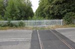
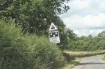
Here are a couple of pictures I took in 2014 of the level crossing in Steeple Claydon. First looking west, second looking east. The rails are about the only thing recognizable. The third one is the warning sign on the approach to the level crossing. There were no warning lights that I could see!
Attachments
Last edited:
Trog
Established Member
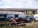
I think one of the piers took a knock during a derailment in the 1980's freight train on one of the slows. Glancing blow on the side but enough to expose some of the reinforcement.
swt_passenger
Veteran Member
- Joined
- 7 Apr 2010
- Messages
- 31,448
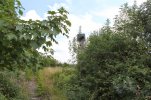
Picture 2 is taken from OXD/29 Charndon Main St bridge, which on the TWA drawings was down for “general repairs and parapet raising”. Seen in the distance is OXD/29A Twyford No 2 footbridge which replaces a footpath crossing.
According to the November Modern Railways, p. 25, the first 440m of the line, from Gavray Junction to Charbridge Lane, Bicester, have been commissioned for engineering trains.
I thought I'd seen a discussion upthread about why this section was so well advanced compared with other sections, but can't find it now, but you can see the stretch in the pics in #239.
I thought I'd seen a discussion upthread about why this section was so well advanced compared with other sections, but can't find it now, but you can see the stretch in the pics in #239.
Last edited:
swt_passenger
Veteran Member
- Joined
- 7 Apr 2010
- Messages
- 31,448
That was a discussion very shortly before the main EWR thread was split and repurposed. It is about mid April in the now fairly dormant “consultation” thread. So you weren’t imagining things…According to the November Modern Railways, p. 25, the first 440m of the line, from Gavray Junction to Charbridge Lane, Bicester, have been commissioned for engineering trains.
I thought I'd seen a discussion upthread about why this section was so well advanced compared with other sections, but can't find it now, but you can see the stretch in the pics in #239.
Last edited:
Elsewhere in the same issue of the magazine (p. 90, Trackwatch) the length commissioned is given as 1 mile 20 ch, about half of which is within the work site.According to the November Modern Railways, p. 25, the first 440m of the line, from Gavray Junction to Charbridge Lane, Bicester, have been commissioned for engineering trains.
Last edited:
swt_passenger
Veteran Member
- Joined
- 7 Apr 2010
- Messages
- 31,448
Would Trackwatch reports normally add up each direction for a two track railway? I’m struggling to fit 1 mile 20 ch into the space available, even if halved…Elsewhere in the same issue of the magazine (p. 90, Trackwatch) the length commissioned is given as 1 mile 20 ch, about half of which is within the work site.
It's saying the length commissioned extends further east than the other report. It says from Gavray Junction (19M 00ch) to 17M 60ch. It says the worksite is entered at 18M 28ch on one track and 18:34 on the other. It says LCs have been abolished at Jarvis Lane, Bicester Eastern Perimeter Road and Manor Farm, and a temporary facing crossover has been put in.Would trackwatch normally add up each direction for a two track railway? I’m struggling to fit 1 mile 20 ch into the space available, even if halved…
swt_passenger
Veteran Member
- Joined
- 7 Apr 2010
- Messages
- 31,448
Oh so the length commissioned includes the junction, so that makes more sense. I think you meant “further west” though?It's saying the length commissioned extends further east than the other report. It says from Gavray Junction (19M 00ch) to 17M 60ch. It says the worksite is entered at 18M 28ch on one track and 18:34 on the other. It says LCs have been abolished at Jarvis Lane, Bicester Eastern Perimeter Road and Manor Farm, and a temporary facing crossover has been put in.
Surely further east? Going east from Oxford through Bicester towards Bletchley, the link to the Chiltern line turns off at what I assume is Gavray Junction (near Gavray Drive), then continuing east you go under the Chiltern line and into the work site? Both versions of the story have the west end of the commissioned length at Gavray Junction.
Last edited:
swt_passenger
Veteran Member
- Joined
- 7 Apr 2010
- Messages
- 31,448
I’m thinking the 400m (or 800m if counted both ways) of brand new track is up to the temporary alignment of Charbridge Lane, which is somewhat short of the old LC and the new bridge. The extra length commissioned must be the existing track and junction just west of the new section. The initial section of 2 track EWR well under the Chiltern line bridge already existed before the works started.Surely further east? Going east from Oxford through Bicester towards Bletchley, the link to the Chiltern line turns off at what I assume is Gavray Junction (near Gavray Drive), then continuing east you go under the Chiltern line and into the work site?
I'm not familiar with the area and didn't have a clear mental picture of which roads are open or diverted, but it looks as though 1M20ch, or about 2km, would take you to a point due north of Launton, about easting 61 on the OS map. If that's incompatible with open roads, well Trackwatch has done retractions before now.
swt_passenger
Veteran Member
- Joined
- 7 Apr 2010
- Messages
- 31,448
The tracks still stop at the temporarily diverted Charbridge Lane. First pic in #239 a few days ago. I think it will be some time yet before they extend towards Launton.I'm not familiar with the area and didn't have a clear mental picture of which roads are open or diverted, but it looks as though 1M20ch, or about 2km, would take you to a point due north of Launton, about easting 61 on the OS map. If that's incompatible with open roads, well Trackwatch has done retractions before now.
I just checked Google satellite view, I think you can see the temporary buffer stops where the existing lines were cut, between the Chiltern mainline bridge and the new Jarvis Lane footbridge, alongside the industrial estate. The overhead view also shows the road diversion route around the new bridge site..
Charbridge Lane is now closed for the next couple of months to commission the new bridge, so it might be quicker than you think.The tracks still stop at the temporarily diverted Charbridge Lane. First pic in #239 a few days ago. I think it will be some time yet before they extend towards Launton.
swt_passenger
Veteran Member
- Joined
- 7 Apr 2010
- Messages
- 31,448
Yes but it was still closed at the time of the Modern Railways article we were discussing.Charbridge Lane is now closed for the next couple of months to commission the new bridge, so it might be quicker than you think.
Well quite. It was still open on Sunday afternoon when it was supposed to be closed tooYes but it was still closed at the time of the Modern Railways article we were discussing.
")
swt_passenger
Veteran Member
- Joined
- 7 Apr 2010
- Messages
- 31,448
So does that look as though they’re closing the temporary road well before, (maybe 3 months or so), the road over the new bridge is finished?Well quite. It was still open on Sunday afternoon when it was supposed to be closed too
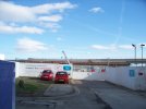
It's closed now until December 17th, and if I recall correctly from the letter that arrived the other week when it reopens there'll only be one lane open for a few months so temporary traffic lights to add to the fun.So does that look as though they’re closing the temporary road well before, (maybe 3 months or so), the road over the new bridge is finished?
What do the yellow boxes do in the middle of the track on the 2nd photo?View from the new bridge over the railway in bicester.
swt_passenger
Veteran Member
- Joined
- 7 Apr 2010
- Messages
- 31,448
That’s the magnet of the AWS (automatic warning system).What do the yellow boxes do in the middle of the track on the 2nd photo?
Last edited:
ThanksThat’s the magnet of the AWS (automatic warning system).
kevin_roche
Member
- Joined
- 26 Feb 2019
- Messages
- 930
When I saw it I was wondering what the plans for signalling on the new line will be. I think all new lines are supposed to be fitted with ETCS, but I guess for the delivery trains they need AWS/TPWS for the time being.That’s the magnet of the AWS (automatic warning system).
swt_passenger
Veteran Member
- Joined
- 7 Apr 2010
- Messages
- 31,448
AFAICT that section is just a reinstatement of the existing system.When I saw it I was wondering what the plans for signalling on the new line will be. I think all new lines are supposed to be fitted with ETCS, but I guess for the delivery trains they need AWS/TPWS for the time being.
The Planner
Veteran Member
- Joined
- 15 Apr 2008
- Messages
- 15,986
E-W will be lights on sticks.When I saw it I was wondering what the plans for signalling on the new line will be. I think all new lines are supposed to be fitted with ETCS, but I guess for the delivery trains they need AWS/TPWS for the time being.
Trainee9
Member
Bletchley Viaduct: The Box over the mainline is looking nearer to completion, with shuttering removed on the Duncombe Street side, revealing the connection between viaduct and Box, (p1061) and on the Eaton Road site side (p1058). More steelwork has been erected for the highlevel station buildings, and an external concrete staircase on the Saxon Street side of the station is also visible (p1056).
Attachments
Last edited:
eMeS
Member
Thanks for your pictures - did you see any signs of a lift installation going in?Bletchley Viaduct: The Box over the mainline is looking nearer to completion, with shuttering removed on the Duncombe Street side, revealing the connection between viaduct and Box, (p1061) and on the Eaton Road side side (p1058). More steelwork has been erected for the highlevel station buildings, and an external concrete staircase on the Saxon Street side of the station is also visible (p1056).
Trainee9
Member
I could not see any signs of a lift installation. Also if there is going to be foot access from Saxon St I wonder how passengers will negotiate the cement works access road and that 20ft high concrete wall. Maybe somebody knows more from prior announcements and drawings?Thanks for your pictures - did you see any signs of a lift installation going in?