Understandably today, speculation on the precise route of phase 2 is rampant with the announcement of the preferred route confirmed for tomorrow.
I must admit to a degree of confusion right now
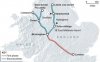
The Telegraph article includes a map purporting to show the approximate route for phase 2 added to phase 1 for comparison purposes - I've attached the image here.
http://www.telegraph.co.uk/news/ukn...ced-for-backlash-over-HS2-northern-route.html
What has confused me is the apparent inclusion of a full spec High Speed link to Liverpool. Now, to the best of my knowledge this never formed part of the brief for phase 2 - the plan was to link Liverpool into HS2 via a spur from phase 2 to the WCML and utilising Classic Compatible Rolling Stock.
What's intriguing here is that the original brief for the Western Arm of phase 2, to link Manchester directly and provide a spur to the WCML for onward routed trainservices to other city locations (inclucing Liverpool) would, logically, have seen a much more direct route than that now "revealed" by the Telegraph - a spur line to Crewe yes but a hub station at Crewe with separate branches to Liverpool and Manchester - NOT in the original brief?
I smell political interference here and the trail leads directly to the door of George Osborne. Under the original plan, a more direct route (which saves loads of money!) would be much further to the east. Now with Crewe directly on the route, the line can conveniently skirt much of Mr. Osborne's constituency instead of cutting straight through its heartlands.
Is a full spec High Speed Line from Crewe to Liverpool really now part of phase 2 - I have my doubts - but it may be provided as an optional future extra, offering a useful sop to the Merseyside lobby, which has been in overdrive for the last couple of years trying to seek parity with its arch rivals down the East Lancs road?
It seems that this relatively late change in design brief might also have provided Mr. Osborne with a fig leaf to hide his politically motivated interference in the final phase 2 route?
Now I'm left figuring out how the phase 2 line is going to avoid Tatton Park, whilst still providing a through running station at Manchester Airport and onward into Manchester City Centre (Mayfield as the site of terminus station?)