• Our booking engine at tickets.railforums.co.uk (powered by TrainSplit) helps support the running of the forum with every ticket purchase! Find out more and ask any questions/give us feedback in this thread!

Longest line of sight (UK)

Howardh

Established Member
Joined
17 May 2011
Messages
8,180
Looking at the Viewfinder Panorama for Scafell Pike facing north, the distant summits stretch to Culter Fell, South Lanarkshire. Dun Rig in the Southern Uplands is also a possible line of sight.


I remember a similar chain of bonfires up the country in the summer of 1988 to mark the anniversary of the Spanish Armada.

On the subject of ‘chains’ of sight, via Viewfinder Panoramas I worked out an extreme chain with as few links as possible that would link a view of the English Channel with a view of the Atlantic in the far north of Scotland.

Starting point: Dartmoor (view south to Portland Bill and English Channel)

Dartmoor to Foel Cwmcerwyn (Pembrokeshire)
Foel Cwmcerwyn to Snowdon (Gwynedd)
Snowdon to Merrick/Lamachan Hill (Dumfries & Galloway)
Merrick to Ben Lui (Southern Highlands)
Ben Lui to Ben Macdui (Cairngorms)
Ben Macdui to Ben Hope (Sutherland)

Ending point: Ben Hope (view north to the Atlantic, North Rona, and Orkney)
Bib - that's something I'd climb up Snowdon in bare feet to see...are there any pics of it anywhere? On Panoramas, Criffel is 131m away.
 
Last edited:
Sponsor Post - registered members do not see these adverts; click here to register, or click here to log in
R

RailUK Forums

Bald Rick

Veteran Member
Joined
28 Sep 2010
Messages
29,209
Looking at the Viewfinder Panorama for Scafell Pike facing north, the distant summits stretch to Culter Fell, South Lanarkshire. Dun Rig in the Southern Uplands is also a possible line of sight.


I remember a similar chain of bonfires up the country in the summer of 1988 to mark the anniversary of the Spanish Armada.

On the subject of ‘chains’ of sight, via Viewfinder Panoramas I worked out an extreme chain with as few links as possible that would link a view of the English Channel with a view of the Atlantic in the far north of Scotland.

Starting point: Dartmoor (view south to Portland Bill and English Channel)

Dartmoor to Foel Cwmcerwyn (Pembrokeshire)
Foel Cwmcerwyn to Snowdon (Gwynedd)
Snowdon to Merrick/Lamachan Hill (Dumfries & Galloway)
Merrick to Ben Lui (Southern Highlands)
Ben Lui to Ben Macdui (Cairngorms)
Ben Macdui to Ben Hope (Sutherland)

Ending point: Ben Hope (view north to the Atlantic, North Rona, and Orkney)

Ben Macdui to Ben Hope is a long way! I’ve seen Ben Wyvis from the Cairngorms, but never Ben Hope. Having said that, on one trip up there I couldn’t see more than about 10 metres in front of me.
 

Scotrail314209

Established Member
Joined
1 Feb 2017
Messages
2,355
Location
Edinburgh
Looking at the Viewfinder Panorama for Scafell Pike facing north, the distant summits stretch to Culter Fell, South Lanarkshire. Dun Rig in the Southern Uplands is also a possible line of sight.


I remember a similar chain of bonfires up the country in the summer of 1988 to mark the anniversary of the Spanish Armada.

On the subject of ‘chains’ of sight, via Viewfinder Panoramas I worked out an extreme chain with as few links as possible that would link a view of the English Channel with a view of the Atlantic in the far north of Scotland.

Starting point: Dartmoor (view south to Portland Bill and English Channel)

Dartmoor to Foel Cwmcerwyn (Pembrokeshire)
Foel Cwmcerwyn to Snowdon (Gwynedd)
Snowdon to Merrick/Lamachan Hill (Dumfries & Galloway)
Merrick to Ben Lui (Southern Highlands)
Ben Lui to Ben Macdui (Cairngorms)
Ben Macdui to Ben Hope (Sutherland)

Ending point: Ben Hope (view north to the Atlantic, North Rona, and Orkney)

I find that insane how you can see from Cumbria to South Lanarkshire and South Ayrshire... really puts into perspective how tiny our little world is.
 

Altrincham

Member
Joined
22 Aug 2011
Messages
262
Bib - that's something I'd climb up Snowdon in bare feet to see...are there any pics of it anywhere? On Panoramas, Criffel is 131m away.


Incredibly, the panorama from Snowdon to Merrick has been captured on photo.

In this first link is the summit comparison (zoomed-in photo):


...and in this second link is the original photo which shows how perfect the conditions were at the time it was taken:


Scotrail314209

Established Member
Joined
1 Feb 2017
Messages
2,355
Location
Edinburgh

Howardh

Established Member
Joined
17 May 2011
Messages
8,180

Scotrail314209

Established Member
Joined
1 Feb 2017
Messages
2,355
Location
Edinburgh
Surely one of the longest or at least a longish one would be from the top of Goatfell on Arran down to North Barrule on the Isle of Man? 98 miles as the crow flys according to viewfinderpanorama.
 

Altrincham

Member
Joined
22 Aug 2011
Messages
262
Surely one of the longest or at least a longish one would be from the top of Goatfell on Arran down to North Barrule on the Isle of Man? 98 miles as the crow flys according to viewfinderpanorama.

That’s incredible to think of, and it’s a vista that I’ve not considered before.

In fact, I’ve just looked at Goatfell on Viewfinder Panorama and I can see that it’s got an incredible range of views.

To the north there’s a panorama to Sgùrr na Cìche, from which it’s possible to see Harris and Lewis.

To the south, there’s a panorama to the Isle of Man and Skiddaw in Cumbria, both with panoramas spanning North Yorkshire, Merseyside, and Snowdonia, and Ireland.
 

DerekC

Established Member
Joined
26 Oct 2015
Messages
2,116
Location
Hampshire (nearly a Hog)
Looking at the Viewfinder Panorama for Scafell Pike facing north, the distant summits stretch to Culter Fell, South Lanarkshire. Dun Rig in the Southern Uplands is also a possible line of sight.


I remember a similar chain of bonfires up the country in the summer of 1988 to mark the anniversary of the Spanish Armada.

On the subject of ‘chains’ of sight, via Viewfinder Panoramas I worked out an extreme chain with as few links as possible that would link a view of the English Channel with a view of the Atlantic in the far north of Scotland.

Starting point: Dartmoor (view south to Portland Bill and English Channel)

Dartmoor to Foel Cwmcerwyn (Pembrokeshire)
Foel Cwmcerwyn to Snowdon (Gwynedd)
Snowdon to Merrick/Lamachan Hill (Dumfries & Galloway)
Merrick to Ben Lui (Southern Highlands)
Ben Lui to Ben Macdui (Cairngorms)
Ben Macdui to Ben Hope (Sutherland)

Ending point: Ben Hope (view north to the Atlantic, North Rona, and Orkney)

The real Armada chain (assuming there was one and it wasn't just an invention by Lord Macaulay) must have used much shorter hops in order to get reliable communication. No good waiting for an ultra-clear day to let people know the Spanish were off the Lizard!
 

peteb

Member
Joined
30 Mar 2011
Messages
1,131
Airborne, not UK, flying from BHX to Perpignan October 2019, flew directly over Limoges, then Perigueux. Altitude 31000 feet. Snow capped mountain range to east horizon, one of which distinctive as Mont Blanc, 20000 feet. Direct line of sight 350 miles.
 

175mph

On Moderation
Joined
25 Jan 2016
Messages
661
I think that was the further away power station. There was one closer nearer Goole.
Speaking of power stations, on a clear day, I've seen the Drax power station whilst crossing the Humber Bridge.
 

Altrincham

Member
Joined
22 Aug 2011
Messages
262
Airborne, not UK, flying from BHX to Perpignan October 2019, flew directly over Limoges, then Perigueux. Altitude 31000 feet. Snow capped mountain range to east horizon, one of which distinctive as Mont Blanc, 20000 feet. Direct line of sight 350 miles.

There’s a photo in this Beyond Horizons link that sounds like it could match what you describe.


Scotrail314209

Established Member
Joined
1 Feb 2017
Messages
2,355
Location
Edinburgh
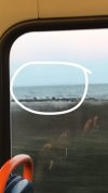
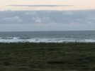
Currently on a service 358 between Girvan and Stranraer, on the coastal road I can make out quite a large landmass in the distance. Can anyone confirm or deny whether or not this is Northern Ireland? (You May need to zoom in a bit to see properly)
 

Attachments

  • A0350429-5C5D-4502-B5AF-B2FAC1441DFC.jpeg
    A0350429-5C5D-4502-B5AF-B2FAC1441DFC.jpeg
    182.6 KB · Views: 43
  • 95140A40-5193-4E97-B63D-BA9F51B496DB.jpeg
    95140A40-5193-4E97-B63D-BA9F51B496DB.jpeg
    1 MB · Views: 44

DerekC

Established Member
Joined
26 Oct 2015
Messages
2,116
Location
Hampshire (nearly a Hog)
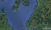
More likely the Mull of Kintyre, I think - about 25 miles away. Northern Ireland would be further south - if you can see anything to the south west it will be N.I, but it's at least 35 miles away depending exactly where you are. Google Earth image attached.
 

Attachments

  • 1605775374051.png
    1605775374051.png
    1.8 MB · Views: 12

Scotrail314209

Established Member
Joined
1 Feb 2017
Messages
2,355
Location
Edinburgh
This was very far south, one of the images I was gazing towards Ailsa Craig which I’ve narrowed down to be the Mull of Kintyre. However a little bit later on I spotted another landmass that was far away but also very prominent, which I assume would be Northern Ireland.

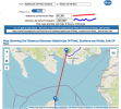
Talking of sight lines. I’m currently on the 500 between Stranraer and Dumfries, looks like I’ve seen the Isle of Man.

How many miles away give or take?
 

Attachments

  • 88932CB6-2622-49CE-A235-8D9E1105AF1E.jpeg
    88932CB6-2622-49CE-A235-8D9E1105AF1E.jpeg
    919.2 KB · Views: 34

LSWR Cavalier

Established Member
Joined
23 Aug 2020
Messages
1,565
Location
Leafy Suburbia
Reminds me of the poem by Housman
'From Clee to heaven the Beacon burns
The shires have seen it plain
..'
Communication by fire or smoke signal relayed from hill top to hill top used to be a thing, surprisingly fast but maybe quite easy to intercept
 

Altrincham

Member
Joined
22 Aug 2011
Messages
262
Currently on a service 358 between Girvan and Stranraer, on the coastal road I can make out quite a large landmass in the distance. Can anyone confirm or deny whether or not this is Northern Ireland? (You May need to zoom in a bit to see properly)

I’m thinking that it is Northern Ireland that you’re seeing there. The A77 travels mostly in a south westerly direction and I think you’re possibly looking directly West.

Looking at some of the Viewfinder Panoramas for the southern uplands, Northern Ireland appears to be the likeliest candidate.
 

Scotrail314209

Established Member
Joined
1 Feb 2017
Messages
2,355
Location
Edinburgh
I’m thinking that it is Northern Ireland that you’re seeing there. The A77 travels mostly in a south westerly direction and I think you’re possibly looking directly West.

Looking at some of the Viewfinder Panoramas for the southern uplands, Northern Ireland appears to be the likeliest candidate.

I know one of them was for definite the end of the Mull of Kintyre, as shortly after I noticed a gap then some more landmass, which I put down to be Northern Ireland. I'm actually very surprised that the Mull of Kintyre is that large tbh.
 

route101

Established Member
Joined
16 May 2010
Messages
10,625
Currently on a service 358 between Girvan and Stranraer, on the coastal road I can make out quite a large landmass in the distance. Can anyone confirm or deny whether or not this is Northern Ireland? (You May need to zoom in a bit to see properly)

Mull of Kintyre is often seen. You see it from Ayr Beach too.

You can see NI on clear days from Girvan and down there.

Oh wow. That’s closer than I thought.

Have you been to the Mull of Galloway, you get a good view of NI, Isle of Man and distant Cumbrian Fells.

I was in Edinburgh few weeks back at Newhaven Harbour, in the distance you could see Ben Lomond or i think it was. Certainly a mountain in the trossachs.
 
Last edited:

Altrincham

Member
Joined
22 Aug 2011
Messages
262
I’ve just been reading an interesting post on an Anglesey Facebook page by someone who was talking about being at the summit of Snowdon in really clear conditions, and they described being able to see the mountains of Mourne in the west, and (through binoculars) “the skyscrapers of Birmingham in the east”.

As much as I like to think that Birmingham could be visible from the top of Snowdon, it isn’t possible due to the Berwyn range (notably Cadair Berwyn) being in the way.

I do know that Liverpool can be seen from the top of Snowdon in clear conditions, which is possibly what this person saw. And I’d like to think that the rapidly expanding high-rise skyline of Manchester could be visible too.

Manchester and Liverpool skylines benefit from being visible from a number of high-level vantages points, notably the hills and mountains of North Wales, as well as the west Pennines and Derbyshire high summits.

It set me thinking about the furthest point from which the skyline of Birmingham would be visible. I’m not even sure if the Birmingham skyline is visible from the Wrekin or Malvern Hills, but I’m interested to know if there is a furthest point that the Birmingham skyline is visible from.
 

Bald Rick

Veteran Member
Joined
28 Sep 2010
Messages
29,209
It set me thinking about the furthest point from which the skyline of Birmingham would be visible. I’m not even sure if the Birmingham skyline is visible from the Wrekin or Malvern Hills,

I’m 99% sure you can’t see Brum from the Wrekin, the southern part of Wolves and Sedgely are in the way.

Not so sure about from the top of Malvern. The Lickey hills will be in the way, but might not quite be high enough to block the top of Brum’s skyscrapers.
 

eMeS

Member
Joined
12 Jun 2011
Messages
954
Location
Milton Keynes, UK
There's a parking place and viewpoint on the A4117, at Clee Hill* (a few miles east of Ludlow) and I've seen what I think is Birmingham from there, but can't say I saw any skyscrapers.
*The summit of Clee Hill itself is a radar station, and I think access may be restricted.
 

Altrincham

Member
Joined
22 Aug 2011
Messages
262
I’m 99% sure you can’t see Brum from the Wrekin, the southern part of Wolves and Sedgely are in the way.

Not so sure about from the top of Malvern. The Lickey hills will be in the way, but might not quite be high enough to block the top of Brum’s skyscrapers.
This is what I’ve been thinking. There’s quite a bit of undulating ground to the west and south west of Birmingham which I think is going to rule out any particular long lines of sight to the skyline,
 

Bald Rick

Veteran Member
Joined
28 Sep 2010
Messages
29,209
There's a parking place and viewpoint on the A4117, at Clee Hill* (a few miles east of Ludlow) and I've seen what I think is Birmingham from there, but can't say I saw any skyscrapers.
*The summit of Clee Hill itself is a radar station, and I think access may be restricted.

More likely you saw Wolves, which you can definitely see from both Clee Hills. Birmingham has (I think) the Clent hills and Warley Woods in the way.
 

Scotrail314209

Established Member
Joined
1 Feb 2017
Messages
2,355
Location
Edinburgh
When you see skyscrapers far away in the distance, to me it just seems really cool. I can’t explain it but does anyone else get that feeling?

On the subject, what’s the longest line of sight you’d be able to see Central London from?
 

Top