• Our booking engine at tickets.railforums.co.uk (powered by TrainSplit) helps support the running of the forum with every ticket purchase! Find out more and ask any questions/give us feedback in this thread!

Making your own route maps

Status
Not open for further replies.

Gemz91

Member
Joined
1 Feb 2013
Messages
683
Location
Garden Shed
Looking at making some of my own route maps for the routes I drive over. Just wondered if anyone has ever made their own route maps and if so what programs did you use on your computer?

I only have paint and don't think it'll be up to the task.
 
Sponsor Post - registered members do not see these adverts; click here to register, or click here to log in
R

RailUK Forums

Ken H

On Moderation
Joined
11 Nov 2018
Messages
6,315
Location
N Yorks
Google maps. You can make your own overlays. But getting the curves right will give you a headache!
 

skyhigh

Established Member
Joined
14 Sep 2014
Messages
5,357
If you've got PowerPoint try setting that to A4 portrait size, it's what I've used for drawing out diagrams though I've not done my own route maps.
 

Mattyblob

Member
Joined
29 Apr 2017
Messages
69
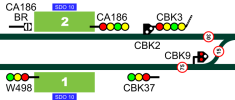
It's a bit of a learning curve if you haven't worked with vector files before but I recommend Inkscape. It's free download and vector files allow you to work really quickly once you've made the initial bits and bobs (create signals, speed restrictions, platforms, etc and you can essentially copy and paste them wherever you like) then all you need to do is label them up. Vectors are also completely scalable so it'll be crystal clear whether you want to get an overview or zoom right in.

ex.png
 

Gemz91

Member
Joined
1 Feb 2013
Messages
683
Location
Garden Shed
It's a bit of a learning curve if you haven't worked with vector files before but I recommend Inkscape. It's free download and vector files allow you to work really quickly once you've made the initial bits and bobs (create signals, speed restrictions, platforms, etc and you can essentially copy and paste them wherever you like) then all you need to do is label them up. Vectors are also completely scalable so it'll be crystal clear whether you want to get an overview or zoom right in.

View attachment 109783

That looks great. I'm a complete novice when it comes to computers but willing to learn so will give it a go.

Cheers
 

43066

Established Member
Joined
24 Nov 2019
Messages
9,463
Location
London
Must admit I found the only way to learn was driving the routes! Appreciate everyone is different in that respect, though.

Track access publications maps (A3 sized booklets convenient for carrying in your bag) are useful for complex areas eg terminal stations, and I’ve annotated mine with information like max train lengths for each platform - useful as a quick reference guide.
 

Gemz91

Member
Joined
1 Feb 2013
Messages
683
Location
Garden Shed
Must admit I found the only way to learn was driving the routes! Appreciate everyone is different in that respect, though.

Track access publications maps (A3 sized booklets convenient for carrying in your bag) are useful for complex areas eg terminal stations, and I’ve annotated mine with information like max train lengths for each platform - useful as a quick reference guide.

I agree mate. I'm already a qualified driver, just fancy making my own maps as a little project. Appreciate your advice though!
 

Stigy

Established Member
Joined
6 Nov 2009
Messages
4,882
I agree mate. I'm already a qualified driver, just fancy making my own maps as a little project. Appreciate your advice though!
I’ve never considered this before, but I can see how it would be good from a route learning perspective. I printed mine off in A5 and laminated them which is good for quick reference but at the same time some of the print can’t be hard to read as it should really be A4.
 

Tomnick

Established Member
Joined
10 Jun 2005
Messages
5,840
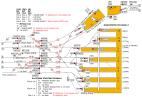
Another vote for Inkscape - brilliant for copying and pasting once you've got the basic components established. The only downside (if I'm not mistaken?) is that you can only work on one page at a time, so if I want to make a booklet then I have to export each page as individual images than drop them into a Word document and print it as a booklet from there. If anyone has a better way then I'd love to hear it!

Personally I've always found it useful to draw my own maps when road learning, preferably beforehand. The act of drawing the maps helps to consolidate the basic knowledge - speeds, crossings etc. - and then they serve as a useful reference for the future.

Manchester Piccadilly.png
 

wobman

On Moderation
Joined
2 Jan 2011
Messages
1,233
Must admit I found the only way to learn was driving the routes! Appreciate everyone is different in that respect, though.

Track access publications maps (A3 sized booklets convenient for carrying in your bag) are useful for complex areas eg terminal stations, and I’ve annotated mine with information like max train lengths for each platform - useful as a quick reference guide.
Im of the same opinion as you, but i also use Track Maps as a reference guide.
it's useful for the more obscure crossing and the Miles & Chains information.
 

Gemz91

Member
Joined
1 Feb 2013
Messages
683
Location
Garden Shed
Another vote for Inkscape - brilliant for copying and pasting once you've got the basic components established. The only downside (if I'm not mistaken?) is that you can only work on one page at a time, so if I want to make a booklet then I have to export each page as individual images than drop them into a Word document and print it as a booklet from there. If anyone has a better way then I'd love to hear it!

Personally I've always found it useful to draw my own maps when road learning, preferably beforehand. The act of drawing the maps helps to consolidate the basic knowledge - speeds, crossings etc. - and then they serve as a useful reference for the future.

View attachment 109791

Cheers for the info. Just started to Download Inkscape, it has a guide for thicko's so I'm liking it already. Handy to know about the one page at a time issue, copy and pasting it into Word gives me a place I'm familiar with. Drawing maps for our road learning was part of my drivers course, but I think it's been dropped on the course now. At the time, our classroom teacher wouldn't even provide us with printed out paper with tracks on, it was insisted we did it all by hand from scratch. I think any benefits from the exercise were lost from drawing endless straight lines with a ruler on a sheet of paper. Lucky enough it was only for a short stretch of our route not it all!

Like the look of your maps. If I am successful at it I'll post what I come up with.
 

T-Karmel

Member
Joined
20 Mar 2010
Messages
395
Location
London
No idea if that's also a case with other TOCs but ARL gives you a blank route map with just tracks and stations on it when you're going out with your Instructor and want you to draw in all the signals but also add all information that you will find useful for yourself - braking points, gradients, places at which there's risk you get distracted by something etc.
 

Efini92

Established Member
Joined
14 Dec 2016
Messages
1,749
Must admit I found the only way to learn was driving the routes! Appreciate everyone is different in that respect, though.

Track access publications maps (A3 sized booklets convenient for carrying in your bag) are useful for complex areas eg terminal stations, and I’ve annotated mine with information like max train lengths for each platform - useful as a quick reference guide.
Agreed, I can’t draw or take anything in on the secondmans side. I have to drive it.
The experience I’ve had with TAPS maps isn’t very good. Very few of the maps have signal indications on and there’s so many mistakes.
 

Frankfurt

Member
Joined
23 Jan 2010
Messages
124
Looking at making some of my own route maps for the routes I drive over. Just wondered if anyone has ever made their own route maps and if so what programs did you use on your computer?

I only have paint and don't think it'll be up to the task.

Have you ever came across Mick Rawlings Simplified maps? He has quite a large library of routes and he's always updating them. They are simple, hold a decent amount of information and there's plenty of room to add your own notes too once printed out. It could save you a job, or would be great to aid you in producing your own.
 

Gemz91

Member
Joined
1 Feb 2013
Messages
683
Location
Garden Shed
Have you ever came across Mick Rawlings Simplified maps? He has quite a large library of routes and he's always updating them. They are simple, hold a decent amount of information and there's plenty of room to add your own notes too once printed out. It could save you a job, or would be great to aid you in producing your own.

Any chance you have a link to them? Tried Googling but couldn't find anything. Cheers.
 

mwest123

Member
Joined
15 Apr 2020
Messages
38
Location
Colchester
Have you ever came across Mick Rawlings Simplified maps? He has quite a large library of routes and he's always updating them. They are simple, hold a decent amount of information and there's plenty of room to add your own notes too once printed out. It could save you a job, or would be great to aid you in producing your own.
Would I be able to have a link too plz? Thanks :)
 

Frankfurt

Member
Joined
23 Jan 2010
Messages
124
I thought Mick's maps were common knowledge, turns out they aren't. Since the link to his Google drive isn't really mine to share I feel I shouldn't - sorry. I've given his email out to a few members, if he permits them to be shared on here then I'll post link.
 

Ashley89

Member
Joined
3 Apr 2019
Messages
6
I thought Mick's maps were common knowledge, turns out they aren't. Since the link to his Google drive isn't really mine to share I feel I shouldn't - sorry. I've given his email out to a few members, if he permits them to be shared on here then I'll post link.
Never heard of them before, Did try to see if could find them on Google. As said on others posts would be good to share his knowledge
 
Status
Not open for further replies.

Top