richieb1971
Established Member
- Joined
- 28 Jan 2013
- Messages
- 1,981


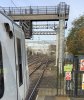
Took these the other day at Sharnbrook.
North and South respectively.
The new section of track in the photos still needs ballast, guess its for thatDid somebody not order enough spoil wagons?
Looking at the heaps of spent ballast tipped on the bank.


certainly starting to look a bit more like the finished article.made good progress here
image upload
Another weekend closure on the MML. Platform extension works in progress at Wellingborough, also looks like the first ohle structure in place on the fast line northbound platform.
Also saw works going on near the Weetabix factory.
Bromham road bridge works going on as well.( I'll add some pics when I arrive into Bedford).

Um, not especially material to the subject, but is the man standing just to the right of the OHLE stanchion real ? He looks a little like one of the Mysterons in civvies.....Photo showing how the ohle structures fit through the station canopy.
P3/4 latest extension work,at the moment foundations and under coping fitted. Just awaiting infill. Lots of work to go on to make P2/3 joined. I'd say still a few months work ahead.
Have you seen the planning application drawings, they're linked in post #2864 of this thread. If you use the third link, then find the documents, the file “Site plan wellingborough station and footbridge extension” shows where the footbridge extension and lift ought to be. The four platform ends will eventually line up across the south end as can be seen. Browsing other applications and files provides a lot of other relevant info...I think that the platforms on the slow/goods line side extend further South than the existing platforms 1 and 2 (12 cars) , but there is no sign of work starting on extending the existing platforms South - they are 10 car at the moment.
Have you seen the planning application drawings, they're linked in post #2864 of this thread. If you use the third link, then find the documents, the file “Site plan wellingborough station and footbridge extension” shows where the footbridge extension and lift ought to be. The four platform ends will eventually line up across the south end as can be seen. Browsing other applications and files provides a lot of other relevant info...
They must have read your post in their office...Used Wellingborough station today and I can report that walls for the F/L platform extension have now been built, and a start made (services in conduits) on the pier for the footbridge extension.
No sooner had I posted that it seemed to have been forgotten that work started. Coincidence, what.
In the full MML electrification Plan where is the next feed point after Braybrooke?
I was just wondering whether if Leicester remodelling went ahead it could only be electrified by wiring from Market Harborough to Leicester?
There are power lines crossing the line just south of EM Parkway (connecting the power station) so that would be the logical place. By adding a relatively short "extension lead" to Trent it would be possible to do things like keeping Nottingham-Derby live while the line south from Trent was isolated.Pretty sure it was supposed to be somewhere between Kegworth and Ratcliffe on Soar Village.
I recall from another document that there was a Mid-Point AT Site at South Wigston, probably in the "triangle" between the MML and the chords leading to Nuneaton.Braybrooke should be able feed to Leicester, about the mid point in mileage.
The new road bridge over the railway at Wellingborough station was opened around lunchtime today.
The map I have shows South Wigston as a SATS, along with Kettering North and Leagrave.
The MPATS's are at East Hyde and Sharnbrook and (at a guess) Leicester.
Don't expect things to stay the same!
WAO
Sectioning Auto Transformer SiteWhat is a SATs and a MPATs please?
Well hopefully once the footbridge extension is and the new drop off area at the Platform 4 side opens that will ease some of the pressure. The completion of the ring road is a couple of years off though, so whilst Irthlingborough traffic will be off Dryden Road now it's still a bad junction as you say heading down to the A45.This should make access to the new housing development easier - there has been a poster inviting prospective purchasers to visit the new housing estate with a map that says 'only 4 miles away' ... but it looks quite close when viewed from the island platform.
As a pedestrian and user of public transport I note that there are 3 light controlled pedestrian crossings around the station on railway land. Unfortunately, when walking from the town centre down Midland Road one has to cross, on a staggered cross-roads, what is effectively the inner ring road just before the station. Whichever side is used, it's effectively blind from one direction and there are no centre refuges, let alone a crossing. When leaving the station, the pavement on the first corner (to the right) is invaded by articulated trailers. At least the council have put down paving - it used to be churned mud - but this just encourages this bad driving. Stagecoach EMT persuaded the council to ban parking around the station (presumably to ensure their expensive car parks were used) but obviously didn't care about the non-car user.