YellowBrick
Member
Can anyone tell me how the online station maps on National Rail are such a catastrophe? They used to be fairly decent.
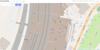
Now there seem to be two styles, and neither is actually legibile, even if you click the "View larger". The platform numbers are a pixelated mess (JPEG compression artefacts; but they were never large enough in the first place) and the icons are tiny and blurry.
2d overhead
 www.nationalrail.co.uk
"cool" 3d view that's even worse
How is anyone supposed to use these?
Now there seem to be two styles, and neither is actually legibile, even if you click the "View larger". The platform numbers are a pixelated mess (JPEG compression artefacts; but they were never large enough in the first place) and the icons are tiny and blurry.
2d overhead
Find a Station | National Rail
You can find information about every single National Rail served station in Great Britain – and there are 2,589 of them! From facilities to access information, ticket buying and collection, onward travel and more helpful knowledge.
"cool" 3d view that's even worse
How is anyone supposed to use these?