londonteacher
Member
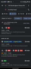
It was simple. Input the two destinations in to Google Maps.Now challenge some random people off the street to find that information.
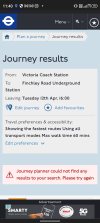
In response to the question whether printed publicity is necessary or not, the main issue with printed information is that as soon as it is printed it is out of date. For example, this weekend in London any bus route that was disrupted due to protests such as the 453 the printed timetables and route maps were factually incorrect. Apps such as Citymapper and Google Maps were updated with the correct routings and stopping patterns meaning people could make the right choices. A solution could be digital signage that updates like the digital price signs in shops like Amazon Fresh that can be updated remotely. In times of disruption routes and timings can then be updated instantly.