• Our booking engine at tickets.railforums.co.uk (powered by TrainSplit) helps support the running of the forum with every ticket purchase! Find out more and ask any questions/give us feedback in this thread!

South Wales 'Metro' updates

adrock1976

Established Member
Joined
10 Dec 2013
Messages
4,450
Location
What's it called? It's called Cumbernauld
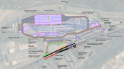
Taff’s Well is being moved north a bit, to allow for a junction into the new depot at the southern end of where the platforms currently are. Presumably the crossover is related to the depot junction?

Yes the southbound track now has a double turnout.

Will the station entrance still be in the same location as present?
 
Sponsor Post - registered members do not see these adverts; click here to register, or click here to log in
R

RailUK Forums

adrock1976

Established Member
Joined
10 Dec 2013
Messages
4,450
Location
What's it called? It's called Cumbernauld
There’ll be a new entrance to the car park at the north end, as the road at the current entrance will be raised to allow the tracks to the depot to run under it.

Here’s a site plan from the planning application:

View attachment 113225

Many thanks for that.

Looking at the blue lines, it seems that the trains/tram trains can turn around in a loop if necessary to balance wheel wear similar as to how the 1949-2009 incarnation of London Underground's Circle Line had one or two journeys that ran to Aldgate East to turn the trains the opposite way round.

I am unsure if the design of the depot is intended for that or not.
 

Brissle Girl

Established Member
Joined
17 Jul 2018
Messages
2,660
Many thanks for that.

Looking at the blue lines, it seems that the trains/tram trains can turn around in a loop if necessary to balance wheel wear similar as to how the 1949-2009 incarnation of London Underground's Circle Line had one or two journeys that ran to Aldgate East to turn the trains the opposite way round.

I am unsure if the design of the depot is intended for that or not.
It's not obvious to me why there would be a materially different amount of wear on the wheels without that (in the way that clearly the Circle Line would have). And the City Line loop services will turn the tram around on a regular basis anyway.
 

edwin_m

Veteran Member
Joined
21 Apr 2013
Messages
24,927
Location
Nottingham
I think the loops are to allow trams to move around the rather compact site between the wash/sand and either stabling or workshop, without having to reverse.
 

59CosG95

Established Member
Joined
18 Aug 2013
Messages
6,495
Location
Between Peterborough & Bedlington

The first of 7 modular substations (in this case, Radyr MPTSS (Mid Point Track Sectioning Site)) has been delivered from Glasgow (where Balfour Beatty's Traction division are based).
Looks like it's going in Sunday night...

Edit: it's in. https://www.linkedin.com/posts/karl..._source=linkedin_share&utm_medium=android_app

The new Radyr MPTSS is located SE of the car park off De Clare Drive:

From the map published in early 2020, the other 6 are at Abercynon, Pontypridd, Upper Boat (Grid Supply), Taffs Well, Taffs Well Depot & Cardiff Queen St. (Canton ATFS is also shown on the map but isn't a deliverable part of the CVL works as far as new infrastructure is concerned)
 
Last edited:

Bob Price

Member
Joined
8 Aug 2019
Messages
1,035
Walked over Gelynis Farm crossing yesterday and noticed a work compound being built both sides of the line. Guessing this is for the new bridge.
 

Attachments

  • DSCF1695.jpg
    DSCF1695.jpg
    4.8 MB · Views: 67

Tomos y Tanc

Member
Joined
1 Jul 2019
Messages
646
Walked over Gelynis Farm crossing yesterday and noticed a work compound being built both sides of the line. Guessing this is for the new bridge.
Presumably.

There were some truly bonkers local objections to the bridge from people who could see no dangers at all from maintaining a barrow crossing on a line being used by 12tph in each direction.

Something to do with spoiling views of Castell Coch apparently!
 

Baxenden Bank

Established Member
Joined
23 Oct 2013
Messages
4,017
Presumably.

There were some truly bonkers local objections to the bridge from people who could see no dangers at all from maintaining a barrow crossing on a line being used by 12tph in each direction.

Something to do with spoiling views of Castell Coch apparently!
People seem to manage to cross roads with a higher frequency of lorries than that, in their millions every day. I'm not sure they are 'truly bonkers' to object.
 

Anonymous10

Established Member
Joined
19 Dec 2019
Messages
2,079
Location
wales
People seem to manage to cross roads with a higher frequency of lorries than that, in their millions every day. I'm not sure they are 'truly bonkers' to object.
stop look listen applies to lorries and diesel trains as you can hear them coming the tram trains being electric can't be heard anywhere near as far away and considering it works out at a trains every aprox 2 mins personally id much prefer a bridge
 

59CosG95

Established Member
Joined
18 Aug 2013
Messages
6,495
Location
Between Peterborough & Bedlington
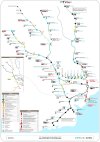
Just attaching the 2020 map again for reference: 20220425_190436.jpg

Note the Route Section Key.
It looks like the RS0 work is being done first:
RS0R2P is at a guess Radyr to Pontypridd - which adds up with the Gelynis Farm bridge work and masts being installed around Treforest Estate.
RS0TAF would be Taffs Well Depot.
RS0ICC would be the adjacent Integrated Control Centre.
RS0CAN would be modifications to Canton - no idea how that's going.
Finally, RS0TPS is for the Track Parallelling Sites (i.e. all the Substations; the first of which was delivered yesterday at Radyr).

Then RS1:
RS1MER for the Merthyr Tydfil line, RS1ABD for the Aberdare line, and
RS1QSS for 'Queen St South' i.e. Queen St to Radyr, Queen St to Cardiff Bay (old), Queen St to Ctl (exc.)

Next, RS2:
RS2QSN for 'Queen St North' i.e. Queen St. (exc.) to Llanishen (exc.), and Queen St (exc.) to Coryton.
RS2THT for the Treherbert Line.

RS3 seems to just be RS3CTL (the City Line) - i.e. Radyr to Ninian Park.
RS4 (well, RS4CRY) appears to be the potential extension of the Coryton Branch to the M4 Park & Ride.

Last but certainly not least, RS5:
RS5BAR is Cardiff Central (inc.) to Ninian Park & Barry Island (no OLE there).
RS5PEN is the Penarth Branch.
RS5BAY is the closure of the old Cardiff Bay station, and the opening of its replacement, along with Loudoun Square.
Finally - the big one - RS5RHY is the Rhymney Line (from Llanishen northwards).

I'd expect the work to take place in numerical order, but it looks as if it may be fluid already - weren't there some masts installed on the Aberdare line recently?
 

Yindee8191

Member
Joined
16 Mar 2019
Messages
159
Just attaching the 2020 map again for reference: View attachment 113605

Note the Route Section Key.
It looks like the RS0 work is being done first:
RS0R2P is at a guess Radyr to Pontypridd - which adds up with the Gelynis Farm bridge work and masts being installed around Treforest Estate.
RS0TAF would be Taffs Well Depot.
RS0ICC would be the adjacent Integrated Control Centre.
RS0CAN would be modifications to Canton - no idea how that's going.
Finally, RS0TPS is for the Track Parallelling Sites (i.e. all the Substations; the first of which was delivered yesterday at Radyr).

Then RS1:
RS1MER for the Merthyr Tydfil line, RS1ABD for the Aberdare line, and
RS1QSS for 'Queen St South' i.e. Queen St to Radyr, Queen St to Cardiff Bay (old), Queen St to Ctl (exc.)

Next, RS2:
RS2QSN for 'Queen St North' i.e. Queen St. (exc.) to Llanishen (exc.), and Queen St (exc.) to Coryton.
RS2THT for the Treherbert Line.

RS3 seems to just be RS3CTL (the City Line) - i.e. Radyr to Ninian Park.
RS4 (well, RS4CRY) appears to be the potential extension of the Coryton Branch to the M4 Park & Ride.

Last but certainly not least, RS5:
RS5BAR is Cardiff Central (inc.) to Ninian Park & Barry Island (no OLE there).
RS5PEN is the Penarth Branch.
RS5BAY is the closure of the old Cardiff Bay station, and the opening of its replacement, along with Loudoun Square.
Finally - the big one - RS5RHY is the Rhymney Line (from Llanishen northwards).

I'd expect the work to take place in numerical order, but it looks as if it may be fluid already - weren't there some masts installed on the Aberdare line recently?
Yes, Aberdare line was the very first to have foundations and then masts installed.
 

WesternBiker

Member
Joined
26 Aug 2020
Messages
606
Location
Farnborough
RS5PEN is the Penarth Branch.
Thanks - really helpful to be reminded of this again.

I see double track is to be reinstated between Penarth and Dingle Road - but it is not clear from this whether Dingle Road is to be restored as a double track station or whether the double track section will stop of short of it?
 

59CosG95

Established Member
Joined
18 Aug 2013
Messages
6,495
Location
Between Peterborough & Bedlington
Thanks - really helpful to be reminded of this again.

I see double track is to be reinstated between Penarth and Dingle Road - but it is not clear from this whether Dingle Road is to be restored as a double track station or whether the double track section will stop of short of it?
I think the double track will end SE of Dingle Rd - from Google Maps there's not much space to add a second track without a compulsory land purchase of the adjoining properties.

Back to RS1ABD, another Google Maps scan of all the overbridges where PES's (Permanently Earthed Sections) are to be installed shows that all bar two of the trough routes for the HV cables carrying traction current have been installed.
The ones I can't quite discern are at Ynysboeth Factory access rd (between Abercynon & Penrhiwceiber) and at Harcourt Terrace FB (north of Penrhiwceiber). The double track at Cwmbach (well, north of Cwmbach to Aberdare) looks to have started being laid too.

Must be a really long TTC to reach over the island platform.
I think they will be, and that should future proof the route for when the existing station closes and gets replaced by the new one - if that happens.
 
Last edited:

Paul Dancey

Member
Joined
25 Jun 2018
Messages
30
I think the double track will end SE of Dingle Rd - from Google Maps there's not much space to add a second track without a compulsory land purchase of the adjoining properties.

Just to mention that evidence of the original second platform at Dingle still exists, but is heavily overgrown and is probobaly crumbling to pieces underneath. The outline of the original building on platform one, which was demolished some years ago, is still in evidence. So I would have thought there ought to be enough space to reinstate a second track through Dingle road.

But having said that the plan only shows a second platform at Penarth with new ramp access. What I can't work out is how they intend to do that. At the moment I don't think there's space for a second line through the station due to redevelopment over the years, let alone another platform. And until extending the line down to lower Penarth becomes more than a pipe dream, it doesn't seem to make much sense to have two platforms at the terminus. Perhaps it will just end up as a passing loop between Dingle road and Penarth for now.
 

WesternBiker

Member
Joined
26 Aug 2020
Messages
606
Location
Farnborough
What I can't work out is how they intend to do that. At the moment I don't think there's space for a second line through the station due to redevelopment over the years, let alone another platform.
I have found this on a Freedom of Information request back in 2019: the short answer seems to be a staggered platform - but the second parts talks about this being on the 'Down' side. With no extension to the buffer stop, does this mean it will be on the other side of the Stanwell Road bridge? The talk of access from the bridge might imply that.

I'm surprised by the reference to "after carrying out a site visit..." - as if the plan were drawn up as a paper exercise without much local knowledge!

Interestingly, the distance quoted - 1.1km - would, I think, take it well through Dingle Road station. Yet the plan makes no mention of a new platform there. It'll be interesting to see what the emerging designs look like.

4. Can you provide a timescale for when TFW/NR plan to double the Penarth Branch as shown on the TFW development map supplied by TFW recently and posted on the ORR website?

The preliminary design stage for doubling the Penarth Branch will commence in January 2020. Penarth is currently a single line known as the Branch Line. A second line is planned and will run in parallel with the existing line for around 1,120 metres. This new line will be called the ‘Down Main’. The new ‘Down Main’ Platform will be staggered to the existing Branch Platform due to site topography. The existing Branch line will be re-named the ‘Up Main’ as post construction there will be two tracks. There are no planned extensions to the existing buffer stop at Penarth.

A new second 120 metre platform will be constructed on the down side. The original proposal was to have a step-down access to the new platform from Stanwell Bridge. However, after carrying out a site visit it is believed People with Reduced Mobility ramp access is feasible. Level Boarding will allow passengers to access a train without having to step up or down.
 

Envoy

Established Member
Joined
29 Aug 2014
Messages
2,478
No Ely Mill station is marked on the map. Has it been dropped? (Ken Skates said it was a priority along with St. Clears in west Wales. No sign off that either).
 

Paul Dancey

Member
Joined
25 Jun 2018
Messages
30
I have found this on a Freedom of Information request back in 2019: the short answer seems to be a staggered platform - but the second parts talks about this being on the 'Down' side. With no extension to the buffer stop, does this mean it will be on the other side of the Stanwell Road bridge? The talk of access from the bridge might imply that.

I'm surprised by the reference to "after carrying out a site visit..." - as if the plan were drawn up as a paper exercise without much local knowledge!

Interestingly, the distance quoted - 1.1km - would, I think, take it well through Dingle Road station. Yet the plan makes no mention of a new platform there. It'll be interesting to see what the emerging designs look like.
Which still leaves me asking what's the point of spending loads of money on a a second platform. Will it mean trains from Cardiff drop passengers off on the existing platform and then reverse onto the new platform to pickup passengers traveling back to Cardiff? or will services alternate between platforms? It just doesn't seem to make sense to me.
 

krus_aragon

Established Member
Joined
10 Jun 2009
Messages
6,045
Location
North Wales
Which still leaves me asking what's the point of spending loads of money on a a second platform. Will it mean trains from Cardiff drop passengers off on the existing platform and then reverse onto the new platform to pickup passengers traveling back to Cardiff? or will services alternate between platforms? It just doesn't seem to make sense to me.
This was a point that confused me back when the plans were first announced. too. I haven't found a reasonable explanation to it (though I admit that I'm not keeping as close an eye on railway things around Cardiff since I moved back up North).
 

hilly

Member
Joined
12 Dec 2012
Messages
55
This was a point that confused me back when the plans were first announced. too. I haven't found a reasonable explanation to it (though I admit that I'm not keeping as close an eye on railway things around Cardiff since I moved back up North).
Presumably if it’s a loop from dingle road to penarth it will allow the frequency to be enhanced as currently only one train can go onto the branch at a time.
 

WesternBiker

Member
Joined
26 Aug 2020
Messages
606
Location
Farnborough
Which still leaves me asking what's the point of spending loads of money on a a second platform. Will it mean trains from Cardiff drop passengers off on the existing platform and then reverse onto the new platform to pickup passengers traveling back to Cardiff? or will services alternate between platforms? It just doesn't seem to make sense to me.
The alternate platform approach works very well to increase frequency for the arrangement for the Tramlink at Wimbledon where there are two staggered faces adjacent to each other. (I'm sure there's a more elegant way of describing that.) That approach wouldn't work so well if you have two separate platforms. One hopes all will be revealed before too long...
 
Last edited:

krus_aragon

Established Member
Joined
10 Jun 2009
Messages
6,045
Location
North Wales
Presumably if it’s a loop from dingle road to penarth it will allow the frequency to be enhanced as currently only one train can go onto the branch at a time.
Correct, but adding a second platform at Penarth (and apparently not at Dingle Road) is the point of confusion on my part, as it doesn't seem to offer any additional benefits over the loop you've described.
 

mrmartin

Member
Joined
17 Dec 2012
Messages
1,012
Correct, but adding a second platform at Penarth (and apparently not at Dingle Road) is the point of confusion on my part, as it doesn't seem to offer any additional benefits over the loop you've described.
Are they even increasing frequency from 4tph on the Penarth branch? If so to what level?
 
Joined
13 Feb 2011
Messages
1,063
Location
Cardiff
No. Remaining at 4tph to/from Penarth.

There is the possibility of the line being extended to Forest Road which I can’t see happening anytime soon.

I’m not 100% sure of the immediate need for a passing loop if I’m honest especially as it’s on the Network Rail part of the network.
 

Dai Corner

Established Member
Joined
20 Jul 2015
Messages
6,351
No. Remaining at 4tph to/from Penarth.

There is the possibility of the line being extended to Forest Road which I can’t see happening anytime soon.

I’m not 100% sure of the immediate need for a passing loop if I’m honest especially as it’s on the Network Rail part of the network.
Better resilience in the event of disruption?

There's going to be a lot of congestion around Queen Street with Taff Valley-Bay and Rhymney Valley-Vale traffic crossing each other's paths. The slightest delay is likely to lead to widespread disruption.
 

WesternBiker

Member
Joined
26 Aug 2020
Messages
606
Location
Farnborough
I’m not 100% sure of the immediate need for a passing loop if I’m honest especially as it’s on the Network Rail part of the network.
But will it be a loop? Or effectively two long sidings to permit two trains on the branch at the same time? The reply to the Freedom of information request doesn’t make it clear.

The bit I still don’t understand is how you can have a section of double track over 1 km long, without having a second platform on Dingle Road, since it is rather closer to Penarth than that. Yet the plans do not include an extra platform in Dingle Road.

Of course, the Freedom of Information reply may contain errors…!
 

Top