• Our new ticketing site is now live! Using either this or the original site (both powered by TrainSplit) helps support the running of the forum with every ticket purchase! Find out more and ask any questions/give us feedback in this thread!

TfL Status updates page (lack of) status map

Joe Paxton

Established Member
Joined
12 Jan 2017
Messages
2,755
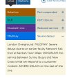
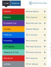
Until the end of last month, the TfL Status updates webpage had - alongside a list of distruptions - a 'status map' of the Underground, London Overground, DLR, Liz Line and Croydon Tramlink, with lines that had disruption (whether planned or not) shown in colour whilst those running normally just in grey (though this could be toggled to be the other way round). Live (realtime) information was shown as a default, but you could also select 'This weekend' or a 'Future date'.

(This is an example of what it used to look like, from 18th November - note that the disconnect in disruption information shown on the map versus on the list on the side is an artefact of how the Internet Archive's Wayback Machine saves pages, i.e. the saved map element is not from the same time as the text - it wouldn't have shown up like this on the day!)

The map appeared on a full screen device, on mobiles it was hidden but appeared on demand once an on-screen button was pressed.

The Status update page still exists, with its listing of information for now, this weekend or a future date - but the map is gone!

Its disappearance appears to have coincided with the launch of the London Overground line names... though there's no reason why the map couldn't have been updated to incorporate them.

The Status updates page does now flag up the existence of a Live status map in the TfL Go app for mobiles, which is great, but it's a shame it's gone from the web. (Plus the TfL Go app's version only shows live information, it doesn't show future dates.) Anyone have any idea if the web version might make a reappearance?

It was my 'go to' page for a quick check of how things are running either right now, or what's planned for the weekend in terms of engineering works. All the information is still listed, but there's no easy to glance at map!
 
Last edited:
Sponsor Post - registered members do not see these adverts; click here to register, or click here to log in
R

RailUK Forums

Silent

Member
Joined
31 Mar 2016
Messages
308
It’s annoying that they took the feature off. I thought that I just forgot how to view the live map.
 

stuu

Established Member
Joined
2 Sep 2011
Messages
3,528
I would guess they haven't had it edited for the new overground lines, although keeping the old version live until they did would be far better
 

Joe Paxton

Established Member
Joined
12 Jan 2017
Messages
2,755
I would guess they haven't had it edited for the new overground lines, although keeping the old version live until they did would be far better

Hopefully it'll make a comeback. Perhaps work on an updated version has been delayed, another victim of the all embracing cyber attack on TfL?

Given that a major part of the LO lines rebranding was to improve information about service distuption, I can see why TfL may not have wanted to carry on using the old map - when widespread weekend engineering works were on, it could look like a bit of a confusing sea of orange. However, I'll give them that leeway only on the basis that the status map will return!
 

HandyHat

Member
Joined
9 Sep 2023
Messages
25
Location
London
It might be worth raising this on the TfL Tech Forum - the TfL staff there are often very helpful when it comes to this sort of thing!
 

edwin_m

Veteran Member
Joined
21 Apr 2013
Messages
26,863
Location
Nottingham

The map was removed three weeks ago when the big Overground digital switchover happened. All the new line names magically appeared down the left hand side but the new colours didn't appear on the map because the underlying programming wasn't up to it. The code was only capable of making everything orange, alas, not distinctly red, blue, yellow, green, purple and grey as required. Nobody had foreseen splitting the lines ten years ago, and the team who put together the digital map had long moved on, so rejigging it for 2024 was neither pragmatic nor appropriate. So they binned it.

This, arguably, is a triumph of branding over practicality. Someone in a high place will have decided that the most important thing was a consistent switch from old Overground to new, displacing the orange overnight. But in removing the orange from the map they've also removed 11 tube lines, Crossrail the DLR and the trams too, extinguishing every last drop of visual information people used to rely on. What's disrupted in west London? Can't show you. Which parts of Crossrail are closed. You'll have to work it out from the text. It is, to put it bluntly, a blinkered sacrifice.
 

Joe Paxton

Established Member
Joined
12 Jan 2017
Messages
2,755

Thanks for that - I should have thought of checking diamond geezer's blog, not least because he covered a quite seperate issue with TfL's Status updates page back in 2018.

Seems bizarre that this incredibly useful facility cannot be updated - surely it's possible to have it recoded! Whilst I do appreciate the TfL of today is somewhat denuded of staff and resources compared to five or ten years ago, it's the kind of visual information tool that a complex network such as London's needs.

It'll now join having a comprehensive collection of updated bus spider maps (as once used to exist) as the top things TfL could do better to communicate better, probably alongside a much improved Single fare finder (for Oyster & contactless).
 

rebmcr

Established Member
Joined
15 Nov 2011
Messages
3,940
Location
St Neots
Presumably this means the Elizabeth line was included in the original code. Otherwise, adding that would have been the same 'impossible' task as replacing the Overground.
 

Joe Paxton

Established Member
Joined
12 Jan 2017
Messages
2,755
Presumably this means the Elizabeth line was included in the original code. Otherwise, adding that would have been the same 'impossible' task as replacing the Overground.

I imagine the code allowed for a degree of updating - e.g. addition of the Elizabeth line (though it has existed on the Tube map since 2015 in the form of 'TfL Rail', the pre-Crossrail completion holding name for the services to the west and east), and the addition of Tramlink in 2016.

Maybe the 21 lines in total now (including DLR, Liz line and cable car) is too many for the code to handle - whilst future needs may have been considered, perhaps it only extended to a top limit of 20 lines or something like that?
 

dosxuk

Established Member
Joined
2 Jan 2011
Messages
2,111
Seems bizarre that this incredibly useful facility cannot be updated - surely it's possible to have it recoded!
It's software, of course it can be recoded.

The question is more whether the need to change the map was identified in advance and the work coated/scheduled in, and now whether TfL are willing to pay for the work to be done after the fact.
 

rebmcr

Established Member
Joined
15 Nov 2011
Messages
3,940
Location
St Neots
It's software, of course it can be recoded.

The question is more whether the need to change the map was identified in advance and the work coated/scheduled in, and now whether TfL are willing to pay for the work to be done after the fact.
If this is done, I would hope that this situation serves as a learning experience, and any replacement is properly scalable — additions (and indeed removals) should be achievable by changing some sort of central registry of lines, rather than changing any hard-coded assumptions.

Otherwise it'll happen again when things like splitting the Northern line, or adopting Moorgate Great Northern take place!
 

lonogrol

Member
Joined
31 Oct 2011
Messages
67
Presumably this means the Elizabeth line was included in the original code. Otherwise, adding that would have been the same 'impossible' task as replacing the Overground.
It is more to do with the back end {if this make sense} which is operated by staff in the London Underground control centre. The program they use still has the overground as one “Line” and the information to station staff still displays this. The system has been cracked to work out what “Line” to display between each two stations on the public view - this is why for example when the Liberty Line/Romford to Upminster was suspended the E.S.U.B boards displayed Part Suspended entire line dispite this obviously not making any sense.

I believe the system update was delayed until Jan, but the Mayor wanted the names to roll out sooner, after all they were all ready delayed due to the cyber incident.
 

rebmcr

Established Member
Joined
15 Nov 2011
Messages
3,940
Location
St Neots
It is more to do with the back end {if this make sense} which is operated by staff in the London Underground control centre. The program they use still has the overground as one “Line” and the information to station staff still displays this. The system has been cracked to work out what “Line” to display between each two stations on the public view - this is why for example when the Liberty Line/Romford to Upminster was suspended the E.S.U.B boards displayed Part Suspended entire line dispite this obviously not making any sense.

I believe the system update was delayed until Jan, but the Mayor wanted the names to roll out sooner, after all they were all ready delayed due to the cyber incident.
That does make sense — so the difference is that the Elizabeth line's addition was simply planned in good time!
 

dosxuk

Established Member
Joined
2 Jan 2011
Messages
2,111
If this is done, I would hope that this situation serves as a learning experience, and any replacement is properly scalable — additions (and indeed removals) should be achievable by changing some sort of central registry of lines, rather than changing any hard-coded assumptions.

Otherwise it'll happen again when things like splitting the Northern line, or adopting Moorgate Great Northern take place!
Who's going to sign off on complete rebuild and map architecture that can accommodate any possible network changes, versus just updating the existing one to accommodate the changes that have happened.

Making a super flexible map might be really easy to justify for someone doing it in their spare time, but for a cash strapped public organisation it's a different matter. Not least getting a formal specification for a map that can do anything is going to be a challenge, that will cost a fair bob just on its own.
 

boiledbeans2

Member
Joined
15 Oct 2020
Messages
761
Location
UK
The TfL status is still a confusing mess. I've observed over the last couple of days - any delay on one Overground line still affects the status of other Overground lines. See the attached screenshot as an example. A delay on the Windrush line is also noted on the Mildmay line status.
 

Attachments

  • mildmay, windrush.jpg
    mildmay, windrush.jpg
    96.1 KB · Views: 82

lachlan79

New Member
Joined
12 Jan 2025
Messages
1
Location
Turnham Green
Thanks. Its annoying as that's the only reason I use the TFL website. I raised this with TFL and yes no plans for it to return.

Otherwise you have to spend 10mins decoding all of this
 

Attachments

  • Screenshot 2025-01-12 112355.jpg
    Screenshot 2025-01-12 112355.jpg
    76.1 KB · Views: 46

Mojo

Forum Staff
Staff Member
Administrator
Joined
7 Aug 2005
Messages
20,877
Location
0035
l don’t like how it shows the station issues in alphabetical order, previously any closed or part-closed stations appeared at the top of the list. Now they appear in alphabetical order amongst the plethora of out-of-order lifts and escalators.
 

Railguy1

Member
Joined
6 Apr 2016
Messages
175
l don’t like how it shows the station issues in alphabetical order, previously any closed or part-closed stations appeared at the top of the list. Now they appear in alphabetical order amongst the plethora of out-of-order lifts and escalators.

Switching between the different transport modes (e.g. clicking the bus tab) is also pretty jarring as it switches back to the “old” user interface.
 

Joe Paxton

Established Member
Joined
12 Jan 2017
Messages
2,755
Switching between the different transport modes (e.g. clicking the bus tab) is also pretty jarring as it switches back to the “old” user interface.

The pages for other modes will undoubtedly be updated soon.
 

317 forever

Established Member
Joined
21 Aug 2010
Messages
2,936
Location
North West
The details are listed a bit better than they were a few days ago. I was looking up Easter Monday and am pleased to understand the Docklands Light Railway listing better than I did then.
 

Top