Jona26
Member
The destinations served (including continental destinations) carved into the stonework on the entrance lodges at Euston and the same at Blackfriars (although those at Blackfriars have been relocated from their original position).
Thanks for that, I meant to do a trawl but didn't get around to it...The South Eastern Railway built shed loads (pardon the pun) of wooden station buildings all over Kent. Unfortunately, as well as having an historical tendancy to burn down (Staplehurst, Ore), NSE also rebuilt a fair few in the 1990's (Marden, Headcorn).
Happily there are a couple of survivors - Bexley on the Dartford loop, and Pluckley on the SE main line and West St Leonards are still with us.
In terms of wooden shelters, Ham Street and Rye have nice ones.

 www.flickr.com
 www.flickr.com
The destinations served (including continental destinations) carved into the stonework on the entrance lodges at Euston and the same at Blackfriars (although those at Blackfriars have been relocated from their original position).
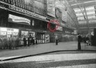
I have looked at old photos of the concourse but not found anything. It was obviously designed to be seen by anyone on the concourse before someone else had the idea to cover it with advertising hoarding. It had clearly been hidden for decades when I saw it in 1975 and even quite ancient photos of the concourse do not reveal it. I would think the best plan would be to locate original drawings showing the concourse offices etc as I think it is definitely an original feature which for some reason fell out of favour. If anyone knows how to locate copies of the drawings on line that would be interesting. I just found this old picture which shows something blurry at more or less the spot I remember seeing it although that was behind hordings by 1975.That rings a bell, don’t suppose anyone can find any photos?
I think that would possibly be Blackfriars (SER) on the Charing Cross route - not to be confused with the former Blackfriars Bridge which was just on the south side of the river on what is now the Thameslink route. I suspect it closed because Waterloo Junction (now Waterloo East) replaced it, long before trams and buses were involved...I never looked myself. But it was claimed that if you walked along the road south from Blackfriars Bridge you came to a railway bridge. The brickwork is different in one place where an entrance to a closed railway station was bricked up. The station was one that was an early closure due to tram and omnibus competition.

From Google Street View you can see that Bearsden had an CCTV notice with the original 1996 SPT logo up until 2017.
The station is fully saltired so it is still very strange.I'd be cautious about relying on the dates on Google Streetview and Maps; there are images on it dated 2020 showing the car I scrapped in May 2018... I think they may be upload dates rather than the dates the images were actually obtained.
There are two dates on Google images from Streetview. Capture when it was actually taken followed by Copyright which will continually update to the most recent year. the capture date is never updated or changed once published.The station is fully saltired so it is still very strange.