• Our booking engine at tickets.railforums.co.uk (powered by TrainSplit) helps support the running of the forum with every ticket purchase! Find out more and ask any questions/give us feedback in this thread!

Trivia: Settlements that perhaps should be in a different local authority

Status
Not open for further replies.

sk688

Member
Joined
11 Sep 2016
Messages
784
Location
Dublin
To all accounts , Bushey is constituent of Watford and adjacent to it , but is governed by Hertsmere BC as opposed to Watford

Similarly I'd say the South Oxhey/Carpenders Park area of Three Rivers district has more in common with Watford than the rest of the district


Similarly most of the Milton Keynes City Council area north of Newport Pagnell/Stony Stratford , ie places like Olney , don't really fit well within that council area either
 
Sponsor Post - registered members do not see these adverts; click here to register, or click here to log in
R

RailUK Forums

Bald Rick

Veteran Member
Joined
28 Sep 2010
Messages
29,315
To all accounts , Bushey is constituent of Watford and adjacent to it , but is governed by Hertsmere BC as opposed to Watford

Similarly I'd say the South Oxhey/Carpenders Park area of Three Rivers district has more in common with Watford than the rest of the district

Watford is best moved out of Hertfordshire (please). London can have it.
 

3141

Established Member
Joined
1 Apr 2012
Messages
1,784
Location
Whitchurch, Hampshire
There's no easy and straightforward answer to organising and re-organising many local government boundaries - rather like the suggested reorganisation of rail franchises which have been put forward from time to time. Some bits can be obvious. But what you're left with when you've done the obvious bits are areas that don't really belong with any of adjacent bits. They are too small to run all services by themselves as a unitary authority, but if they are tacked on to one of their bigger neighbours there will always be complaints about how, because they are small or distant or the other side of some major road, they always ignored or unfairly treated by the council based in the major town of the area they've been attached to. There are examples of that earlier in this thread.

There is also a political component. Setting up Medway as a UA took a Labour area out of Kent and enabled Conservatives to regain control there. Similarly with Thurrock and Essex, and Portsmouth and Southampton in relation to Hampshire.
 

Gathursty

Established Member
Joined
31 May 2011
Messages
2,531
Location
Wigan
But you're not that keen on being in Manchester either!
Greater Manchester makes much sense as Wigan, Leigh, Bolton, Rochdale, Bury, Oldham, Stockport etc... are all former Mill towns with shared identity. Not sure where posh Trafford and Altrincham fits in with the rest of us but they help to pay council tax bills so won't whinge too much at them haha!

It's funny to put a 'Lankyshire' accent on now and then but I think younger Wiganers nowadays think of Wigan by itself or Greater Manchester.
 

Tetchytyke

Veteran Member
Joined
12 Sep 2013
Messages
13,335
Location
Isle of Man
Much more closely aligned with Otley (which is in Leeds Met Boro) and, if you want a trip for the finer things in life, it's arguably easier to get into Leeds rather than Bradford and nicer too. Bradford is closer as the crow flies but there really is no connection, geographically or culturally, between Ilkley and Bradford.

Otley doesn’t much like being part of Leeds either. When Leeds City Council started putting up huge WELCOME TO LEEDS signs on the local authority boundary, the ones in Wharfedale were vandalised as soon as they were put up.

Meanwhile we have Millom bizarrely now in Cumberland rather than Westmorland and Furness; also Penrith is now not in Cumberland, falling in Westmorland and Furness. Yet another bewildering boundary change which is simply going to cause speculation of political motivations.

The whole division of Cumbria was…interesting, shall we say. And by interesting I mean “yet another example of Tory gerrymandering”.
 

156421

On Moderation
Joined
23 Aug 2022
Messages
305
Location
Weſtmorland 'n' Furneß
Otley doesn’t much like being part of Leeds either. When Leeds City Council started putting up huge WELCOME TO LEEDS signs on the local authority boundary, the ones in Wharfedale were vandalised as soon as they were put up.


The whole division of Cumbria was…interesting, shall we say. And by interesting I mean “yet another example of Tory gerrymandering”.
Westmorland and Furness is now ruled by fibdems. Traffic free neighborhoods coming to Barrow soon no doubt!!
 

adrock1976

Established Member
Joined
10 Dec 2013
Messages
4,450
Location
What's it called? It's called Cumbernauld
Westmorland and Furness is now ruled by fibdems. Traffic free neighborhoods coming to Barrow soon no doubt!!

Is/was the former Westmoreland County Council functions (before 1974) shared between Kendal and Appleby? (Similar as how Surrey CC is shared between Kingston upon Thames and Guildford).

I am aware that the post 1974 District Council under Cumbria CC was shared between the two.
 

D6130

Established Member
Joined
12 Jan 2021
Messages
5,915
Location
West Yorkshire/Tuscany
Otley doesn’t much like being part of Leeds either. When Leeds City Council started putting up huge WELCOME TO LEEDS signs on the local authority boundary, the ones in Wharfedale were vandalised as soon as they were put up.
Likewise Wetherby!....and the good (and rich) people of Ilkley are not too happy about being in Bradford MBC's area, or sharing an MP with Keighley, which makes for a highly marginal seat.
 

urbophile

Established Member
Joined
26 Nov 2015
Messages
2,111
Location
Liverpool
Likewise Wetherby!....and the good (and rich) people of Ilkley are not too happy about being in Bradford MBC's area, or sharing an MP with Keighley, which makes for a highly marginal seat.
Every seat currently held by a Tory, or with a small anti-Tory majority, is marginal these days.
 

Old Yard Dog

Established Member
Joined
21 Aug 2011
Messages
1,487
The boundaries of the five West Yorkshire local authorities are ridiculously asymmetric. Bradford stretches some 13 miles northwestwards to Ilkley and Silsden yet finds suburbs like Tyersal and parts of Thornbury "occupied" by Leeds and East Bierley by Kirklees. These suburbs are only about two miles from Bradford city hall.

The real boundary between Bradford and Leeds is Stanningley Bottom. That is where Bradford's 4' gauge trams terminated and Leeds's standard gauge trams began. Some vehicles were even capable of changing gauge en route to allow through working.

This all happened because they didn't want to split up what was Pudsey Council in the 1974 local government reorganization. So they gave the whole lot to Leeds.
 

Enthusiast

Established Member
Joined
18 Mar 2019
Messages
1,197
Very good candidates for such a change are the large parts of the outer stretches of “Greater London” which were subsumed into the GLC’s authority in 1965.

Many areas of outer London have nothing in common with London whatsoever. In particular, large areas of the boroughs of Havering and Bromley are open farmland. A small part of Havering actually extends beyond the M25. The borough of Bromley is the largest London borough but has no Underground stations and is only served by three Overground stations (Crystal Palace, Penge West and Anerley) in its north-western extremity.

There is form for such a transfer. Among the former Urban Districts captured under the 1965 land grab by the GLC was Orpington. This included the village of Knockholt. However, a concerted effort by the villagers to remain in Kent was successful and in 1969 that area was transferred to Sevenoaks Rural District.
 

DynamicSpirit

Established Member
Joined
12 Apr 2012
Messages
8,284
Location
SE London
Watford is best moved out of Hertfordshire (please). London can have it.

If London had had Watford 15 years ago, maybe the Met line would be running to Watford Junction today ;)

Dartford strikes me as odd that it's in Kent. It's in a continuous urban area that stretches into London, and the transport links by and large head into London: It even, unusually for a town outside London, is on several TfL bus routes.

On the other hand, I find it surprising that the very rural area around Biggin Hill is in London: Whenever I go there it feels much more like Surrey. Having said that, being in London does mean it benefits from a much better bus service than it otherwise would be likely to have.

A pie in the sky idea, but I might think Farnborough and Aldershot should move into Surrey County Council.


I would guess because the whole set of communities between Farnham and Camberley/Yateley has pretty much become one single multi-centred urban area that maybe should be managed as such, and you can't help but wonder if it's being held back by having county boundaries cut East-West right through it.
 
Last edited:

adrock1976

Established Member
Joined
10 Dec 2013
Messages
4,450
Location
What's it called? It's called Cumbernauld
Willenhall - currently in Walsall but very much has a Wolverhampton identity and very strong links to my city.

Originally being from the West Midlands myself, Willenhall (formerly in Staffordshire - not to be confused with the Willenhall in Coventry, which was formerly in Warwickshire) has surprised me as being part of Walsall MBC being as it has a high WV postcode (centred on Wolverhampton).

The rest of Walsall MBC is allocated a WS postcode (centred on Walsall and Wednesbury).

Tamworth once straddled both Staffordshire and Warwickshire, but when postcodes were rolled out across the whole of Great Britain, Tamworth was allocated a high B postcode (centred around Birmingham) probably as the former GPO was on the Warwickshire side of the River Anker. Eventually, the whole of Tamworth was brought into the county of Staffordshire, and is the only post town in Staffs that has a B postcode (the others having ST (Stoke on Trent and Stafford), High WS for Lichfield, Cannock, etc, DY7 for Kinver, Bobbington, etc, and WV for Wombourne, Featherstone nick, etc.
 

Dai Corner

Established Member
Joined
20 Jul 2015
Messages
6,395
Originally being from the West Midlands myself, Willenhall (formerly in Staffordshire - not to be confused with the Willenhall in Coventry, which was formerly in Warwickshire) has surprised me as being part of Walsall MBC being as it has a high WV postcode (centred on Wolverhampton).

The rest of Walsall MBC is allocated a WS postcode (centred on Walsall and Wednesbury).

Tamworth once straddled both Staffordshire and Warwickshire, but when postcodes were rolled out across the whole of Great Britain, Tamworth was allocated a high B postcode (centred around Birmingham) probably as the former GPO was on the Warwickshire side of the River Anker. Eventually, the whole of Tamworth was brought into the county of Staffordshire, and is the only post town in Staffs that has a B postcode (the others having ST (Stoke on Trent and Stafford), High WS for Lichfield, Cannock, etc, DY7 for Kinver, Bobbington, etc, and WV for Wombourne, Featherstone nick, etc.
I may have said this before in this thread, but remember that postcodes are a routing table for mail, not a geographical database.

My usual example is Aberystwyth having SY postcodes because back in the day it's mail came by train via Shrewsbury.
 

Enthusiast

Established Member
Joined
18 Mar 2019
Messages
1,197
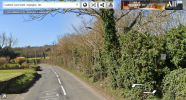
On the other hand, I find it surprising that the very rural area around Biggin Hill is in London: Whenever I go there it feels much more like Surrey.
Here's a snap of that part of "London". As you can see, it looks like open farmland. That Road (Cudham Lane North) links the village of Cudham with Green Street Green. It is about two miles in length and is typical of roads in that part of the London Borough of Bromley. It is served by one bus (R10) with six journeys a day towards Orpington (last bus 19:50, Monday-Saturday only). Many homes in that area are in Council Tax Band H and householders pay £2,816 to the London Borough of Bromley and £868 to the Greater London Authority. Quite what they get, apart from the infrequent R10, for that £868 is a bit of a mystery.

1687890003656.png
 

davehsug

Member
Joined
8 Jul 2014
Messages
230
Originally being from the West Midlands myself, Willenhall (formerly in Staffordshire - not to be confused with the Willenhall in Coventry, which was formerly in Warwickshire) has surprised me as being part of Walsall MBC being as it has a high WV postcode (centred on Wolverhampton).

The rest of Walsall MBC is allocated a WS postcode (centred on Walsall and Wednesbury).

Tamworth once straddled both Staffordshire and Warwickshire, but when postcodes were rolled out across the whole of Great Britain, Tamworth was allocated a high B postcode (centred around Birmingham) probably as the former GPO was on the Warwickshire side of the River Anker. Eventually, the whole of Tamworth was brought into the county of Staffordshire, and is the only post town in Staffs that has a B postcode (the others having ST (Stoke on Trent and Stafford), High WS for Lichfield, Cannock, etc, DY7 for Kinver, Bobbington, etc, and WV for Wombourne, Featherstone nick, etc.
Not forgetting DE for the Burton area and SK for parts of the Staffordshire Moorlands!
 

Ridercross

Member
Joined
23 Aug 2020
Messages
99
Location
Midlands
The whole strange bit of South Staffordshire from Codsall and Billbrook down to Kinver is sandwiched between West Midlands and Shropshire. This area is so much closer to Wolverhampton or Stourbridge is terms of facilities, roads and bus and rail routes than the rest of Staffordshire.

I suspect that the affluent residents would never want to leave a "shire" county and move into the West Midlands though!
 

nr758123

Member
Joined
3 Jun 2014
Messages
489
Location
West Yorkshire
Rossendale has been described as "all the bits the neighbouring local councils didn't want". Certainly Whitworth seems to belong much more to Rochdale.
 

A Challenge

Established Member
Joined
24 Sep 2016
Messages
2,823
The Glossop area of High Peak, Derbyshire feels like it should be Greater Manchester rather than Derbyshire, and in fact Derbyshire going up all the way to High Peak is a bit strange (but the Hope Valley going to Manchester would be rather odd, so not sure where it would go)
 

gg1

Established Member
Joined
2 Jun 2011
Messages
1,929
Location
Birmingham
I used to live in one example:

Rubery - currently divided between Bromsgrove and Birmingham local authorities, should really be wholly within Brum as it's part of the West Midlands conurbation.
 
Joined
25 Jan 2016
Messages
549
Location
Wolverhampton
The parts of Silverstone Circuit, which are in the Buckingham East and Buckingham West wards of Buckinghamshire, should be transferred into the Silverstone ward of West Northamptonshire.

The county boundaries runs through the circuit and means the track is under the jurisdiction of:

- 2 Regions in the East Midlands and South East;

- 2 Councils in West Northamptonshire and Buckinghamshire;

- 2 MP’s in South Northamptonshire (Andrea Leadsom) and Buckingham (Greg Smith), which will become Buckingham and Bletchley under the new Westminster boundaries;

- 3 Council Wards (Silverstone in West Northamptonshire and Buckingham West and Buckingham East in Buckinghamshire);

- AND 9 Councillors, with the 3 wards having 3 Councillors each!
 

InkyScrolls

Member
Joined
20 Jul 2022
Messages
941
Location
North of England
Yarm should be in North Yorkshire, not Stockton. Indeed, the local residents had a referendum to say so:


Barnoldswick should be back in Yorkshire, where it used to be. They have a Yorkshire flag flying in the town centre.


I consider everywhere between the Tyne and the Tees to be County Durham. And the other side of the Tyne is Northumberland.
Hear hear!

If the Yorkshire ridings were to be brought back, this could be tricky as the Western part is more urbanised that the Selby, Harrogate and Craven areas, being more rural, could find themselves eclisped by Leeds, Sheffield etc. Also York has since expanded outside the city walls.

Current day South Yorks & West Yorks both could be reformed into a "new West Riding" though more urbanised than its pre-1974 state. And the rural ex-West Riding parts of Craven & Harrogate could go in the North Riding, with Selby joining Goole in the East Riding.

The existing East Riding would continue as a unitary area though with inclusion of Selby, the new North Riding would be a new unitary area with Craven & Harrogate included (though smaller than North Yorks of today). The new West Riding likely would be current W & S Yorkshire merged with existing urban council areas (Doncaster, Kirklees etc) continuing to be administered separately rather than one large unitary area.

The current City of York unitary area could remain as it is, with 1996 borders, as York wasn't really part of any riding as it was inside the city walls before the 1974 changes.
Seconded.
 

xotGD

Established Member
Joined
4 Feb 2017
Messages
6,117
Likewise Wetherby!....and the good (and rich) people of Ilkley are not too happy about being in Bradford MBC's area, or sharing an MP with Keighley, which makes for a highly marginal seat.
Ilkley came close to electing a Green Councillor in May. They aren't as true blue as we might think!
 
Joined
10 Jan 2018
Messages
285
Rutherglen and Cambuslang were under City of Glasgow up to 1996 and should have been transferred to Glasgow City Council, but they went to South Lanarkshire Council instead.
 

adrock1976

Established Member
Joined
10 Dec 2013
Messages
4,450
Location
What's it called? It's called Cumbernauld
Rutherglen and Cambuslang were under City of Glasgow up to 1996 and should have been transferred to Glasgow City Council, but they went to South Lanarkshire Council instead.

Before Rutherglen got swallowed up into Glasgow many moons ago, it was a former Royal Burgh in its own right (similar to Queensferry being a former Royal Burgh before it got stalled up by Edinburgh).

Regarding the break up of the Regional Councils in 1996, they should have been left alone as the functions all seemed to have worked far better than today. For example, when I was on a bus journey in November 2022 from Cumbernauld to Bishopbriggs via Kirkintilloch, East Dunbartonshire Council do not know how to plan roadworks at all. There was two sets along Waterside Road, one set along Lenzie Road, and another set for well over half a mile along the A803 Glasgow Road all at the same time along these main arterial roads. Needless to say, the buses were running totally haywire with gaps of up to around 50 minutes or so. In the days of Strathclyde RC, there would only have been one main arterial road at a time with roadworks.

The former Cumbernauld and Kilsyth District Council in 1996 was tagged on to North Lanarkshire, despite both towns having never been a part of Lanarkshire at all. Before the regional councils were introduced in 1975, Kilsyth was part of Stirlingshire and Cumbernauld was in Dunbartonshire.
 
Status
Not open for further replies.

Top