-
Our booking engine at tickets.railforums.co.uk (powered by TrainSplit) helps support the running of the forum with every ticket purchase! Find out more and ask any questions/give us feedback in this thread!
You are using an out of date browser. It may not display this or other websites correctly.
You should upgrade or use an alternative browser.
You should upgrade or use an alternative browser.
Walking and Rambling discussion
- Thread starter johnnychips
- Start date
Sponsor Post - registered members do not see these adverts; click here to register, or click here to log in
R
RailUK Forums
High Dyke
Established Member
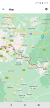
Spent yesterday afternoon taking a further stroll along part of the Thames Path. Starting from Putney Bridge station, and crossing the river via the footbridge. Picking up the path towards the city.
A stop off at The Ship pub on the way for a quaffable pint of Young's beer. Onwards to Albert Bridge and the end of the short section. I then continued through Battersea Park heading for the new tube station; it would be rude not to score that route. On the way I spotted this sign attached to the over-bridges near Battersea Dogs Home. Graffiti aside, I wonder how it's survived.

A stop off at The Ship pub on the way for a quaffable pint of Young's beer. Onwards to Albert Bridge and the end of the short section. I then continued through Battersea Park heading for the new tube station; it would be rude not to score that route. On the way I spotted this sign attached to the over-bridges near Battersea Dogs Home. Graffiti aside, I wonder how it's survived.
Kite159
Veteran Member
I made the most of the Good Friday sunshine to walk the Kennet & Avon canal from Devizes towards Avoncliff, just over 15 miles. Making the most of the £2 bus single with a bus journey from Trowbridge to Devizes on the Stagecoach 49 service for Swindon.
Towpath was mostly solid ground with some areas of mud + puddles, but restricted to some parts of Devizes and Bradford to Avoncliff (which by far was the worse part). It did get narrow in some places so not ideal to ride along (I think it was all route 4).
Nice Wiltshire countryside, very busy in terms of boats moored up in places.
----
Saturday Edit:
Another Wiltshire walk today, starting from the picture postcard village of Lacock, following a few footpaths to reach a restored section of the Wilts & Berks Canal. I carried along towards Chippenham following a cycle route which went close to the River Avon, carrying on via the town centre to the Monkton Park area of the town (housing). I then picked up the disused Calne branch line for a ~ 6 mile walk in the countryside, with a brief section of walking on a quiet lane in the Stanley area. The disused railway path was solid ground but with areas of mud & puddles, very peaceful.
Last edited:
johnnychips
Established Member
I did something today I’ve always wanted to do: I asked the guard to stop at a request stop, and I was the only person getting off!
I took the train from Tenby to Lamphey, walked to the coast at Freshwater East, then took the Pembrokeshire Coast Path back. The scenery did not disappoint, but I did get caught out by the large number of ‘ups-and-downs’. It took six hours to do sixteen miles, but on working it out on my OS app when I got back, I found to my horror/pride that I had ascended 911m.
Just before arriving back into Tenby, I got terrible cramp in both my thighs, which could only be cured by standing stock-still for five minutes. Fortunately it went, and hasn’t come back. I would advise younger forum members not to get old.

I did something today I’ve always wanted to do: I asked the guard to stop at a request stop, and I was the only person getting off!
If you like request stops where there’ll be no one, I’d recommend Braystones or Nethertown on the Cumbrian Coast. The latter is my favourite, and it’s very peaceful.
Peter Mugridge
Veteran Member
First walk of 2023...
Clacton on Sea railway station to Walton on Naze railway station, including Clacton pier, 8 miles in 4½ hours, Saturday 8th April 2023.
Originally planned for 16th July 2022, but on that occasion we derailed three miles short of Clacton which forced an abort to the plans.

Clacton on Sea railway station to Walton on Naze railway station, including Clacton pier, 8 miles in 4½ hours, Saturday 8th April 2023.
Originally planned for 16th July 2022, but on that occasion we derailed three miles short of Clacton which forced an abort to the plans.
johnnychips
Established Member
The train derailed?! Obviously you are ok, or you wouldn’t be posting.First walk of 2023...
Clacton on Sea railway station to Walton on Naze railway station, including Clacton pier, 8 miles in 4½ hours, Saturday 8th April 2023.
Originally planned for 16th July 2022, but on that occasion we derailed three miles short of Clacton which forced an abort to the plans.
The other route on the coast south-west of Clacton to Jaywick is…interesting.
Last edited:
Peter Mugridge
Veteran Member
I suspect you must have missed the thread that I created live from on board moments after it happened...?The train derailed?! Obviously you are ok, or you wouldn’t be posting.
The other route on the coast south-west of Clacton to Jaywick is…interesting.
Derailment between Thorpe le Soken and Clacton (16/07/22)
The 10.18 from Liverpool Street to Clacton has hit four cows and derailed one axle roughly three miles short of Clacton. Nobody on board is hurt, but obviously the Clacton line will be out of action for the rest of the day. It's 720 528 leading 720 573, before anyone asks. I'm in the front...
www.railforums.co.uk
As for Jaywick... could you tell me a bit more about that please? I can't see anything out of the ordinary on Google Maps or Streetview...?
johnnychips
Established Member
Sorry, I did miss that thread. As for Jaywick, it is supposed to be the most deprived area in the UK, not some inner-city place that you might expect. When I went there, it was the quality of its housing stock that looked terrible.I suspect you must have missed the thread that I created live from on board moments after it happened...?
Derailment between Thorpe le Soken and Clacton (16/07/22)
The 10.18 from Liverpool Street to Clacton has hit four cows and derailed one axle roughly three miles short of Clacton. Nobody on board is hurt, but obviously the Clacton line will be out of action for the rest of the day. It's 720 528 leading 720 573, before anyone asks. I'm in the front...www.railforums.co.uk
As for Jaywick... could you tell me a bit more about that please? I can't see anything out of the ordinary on Google Maps or Streetview...?
Last edited:
Peter Mugridge
Veteran Member
Hmm... I think I'll give that walk a pass...As for Jaywick, it is supposed to be the most deprived area in the UK, not some inner-city place that you might suppose. When I went there, it was the quality of its housing stock that looked terrible.
ChrisC
Established Member
I did that walk in the opposite direction about 4 years ago. I found it quite an interesting walk. I was fascinated with all the beach huts at different levels at the Walton on Naze end. The section from Frinton to Holland on Sea was a nice undeveloped section of coast in a generally built up area.First walk of 2023...
Clacton on Sea railway station to Walton on Naze railway station, including Clacton pier, 8 miles in 4½ hours, Saturday 8th April 2023.
Originally planned for 16th July 2022, but on that occasion we derailed three miles short of Clacton which forced an abort to the plans.
As for Jaywick! I had a ride there on the bus, just to have a look, and parts of it are unbelievable. The standard of housing is appalling and generally in a state of disrepair. What struck me was the heaps of rubbish in the streets and in peoples gardens. Just take a look on Google earth at the streets down the far end, just off the sea front at Jaywick Beach towards the Martello Tower.
railwalker
Member
Haven't seen it mentioned on here but the friends of the Settle-Carlisle line do weekly walks (mainly Saturdays) All start and finish at a railway station. Some are circular walks, others start at one station and finish at another.
They are also running a week of walks called ride2stride later this months
All the walks are free.
https://www.foscl.org.uk/
 www.ride2stride.co.uk
They are also running a week of walks called ride2stride later this months
All the walks are free.
https://www.foscl.org.uk/
ride2stride
ride2stride is a festival of walks, talks and music along the fabulous Settle-Carlisle railway line.
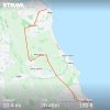
I've walked from Southease station to Eastbourne via the Seven Sisters and agree that section is beautiful, especially if the sun is out with the bright white cliffs contrasting with the blue sea and sky.On Good Friday I walked the Seven Sisters from Seaford to Eastbourne.
A highly recommended but tough walk!
View attachment 132670
THC
Member
Kite159
Veteran Member
I made the most of the sunshine this morning/early afternoon in London to walk along the Lea Navigation from Tottenham Hale to Enfield Lock as a late decision. Towpath on solid ground, bit narrow in places with some puddles from the rain on the Tuesday.
Changes from residential to industrial with some 'rural' thrown in with the area with a golf club. I had good timing as I got to Enfield Lock station just as the rain started.
Good weather forecast tomorrow, so I will do the disused railway path from Marlborough towards Swindon, followed by some bits in Swindon itself
Last edited:
johnnychips
Established Member
You are certainly getting the miles in recently! I did another walk in Pembrokeshire on Monday from Narberth to Tenby, finishing on an outrageously muddy coast path; but the last two days have been a literal washout. Hoping to get my boots back on tomorrow, and do another first, using a demand-response bus to get to my starting point at Broad Haven.Great Dunmow to Newport. 15.2 miles through my favourite part of Essex amid four seasons in one day. The hailstones were more the size of garden peas than golf balls but they still count.
THC
Kite159
Veteran Member
I had 4 and a bit hours in Glasgow yesterday so walked the 'Clyde Walkway' path from the city centre towards Newton, picked the North bank (as there is also a path on the south bank until the Dalmarnock area). Decent surface and some nice views of the river, although it was hidden behind trees at times. Ended up with a short disused railway walk in Westburn.
Worst part was the loop near the Dalmarnock Waste Water Treatment Works, wee bit smelly. Best part was the section of woodland near Braidfauld, until the river came close to the motorway. 9.7 miles and straight onto a train for the not-so scenic route via Langside [probably should have checked before jumping on!]
Today, the weather was nice and sunny so I took a bus from Crewe to the Barbridge/Wardle area (where the Middlewich branch comes in) to walk the Shropshire Union canal to Chester. Beautiful in places where it's very rural, towpath was grassy with some areas of mud (mixed up with some areas of hard stones and dirt, until the Waverton area where the path turned tarmac for the run into Chester. Just over 17 miles so not bad going
Looking at the map, it looks like the next section of the Shropshire Union for me will be Market Drayton towards Nantwich as South of Market Drayton seems to be quite rural with not a lot of bus options.
Last edited:
Walked the sea wall between Dawlish Warren an Dawlish three times last week.
Be much better when it’s fully open past Dawlish station. Pity there doesn’t look like there’s access to the station. Can imagine some people will be shimmying over the wall to get to their train.
Also walked from Lympstone to Exmouth.
Be much better when it’s fully open past Dawlish station. Pity there doesn’t look like there’s access to the station. Can imagine some people will be shimmying over the wall to get to their train.
Also walked from Lympstone to Exmouth.
railwalker
Member

Kite159
Veteran Member
Breaking in my latest pair of walking boots this weekend. Yesterday i did a enjoyable 10odd mile walk in the Chichester area. Headed along the Chichester canal towards the marina before following a mix of permissive paths & footpaths along the harbour side with some excellent views. Ended up in Fishbourne (as the timings worked out well).
Today I did a 15 mile walk from Bath city centre towards Bradford on Avon along the canal with some small detours via Bathampton Meadows, Somerset Coal Canal, Dundas Aqueduct & Warleigh Weir. Another section of the Kennet & Avon canal done, leaves Devizes to Hungerford (splitting at Pewsey) plus the River Avon part which I will probably split at Keynsham.
Thankfully the weather has been reasonable for both, a few times where it's tried to drizzle for a short period but mostly dry.
Last edited:
THC
Member
Hungerford to Bristol, 73 miles over 3 days:
Hungerford to Devizes, 28 miles. Day 1 of 3 on the Kennet and Avon Canal towpath towards Bristol and a windy but mainly dry day to start. The highlight was feeding cheese and onion crisps to a pub chicken who then decided I was her new BFF. Cute.
Devizes to Bath, 26 miles. Day 2 of 3 on the Kennet and Avon Canal towpath where I was joined by a couple of old friends from my university days. A cloudy morning gave way to a beautifully sunny afternoon which lit up Bath spectacularly for our arrival.
Bath to Bristol, 19 miles. Day 3 of 3 and onto the River Avon Trail to finish. A very different walking experience to the K&A - the countryside opened out on leaving Bath but narrowed again as we neared Bristol. A couple of pints at Hanham made the last few miles an altogether easier proposition as after 70 miles my feet were rather sore!
THC
Attachments
Kite159
Veteran Member
I need to do Hungerford to Devizes of the K&A, will most likely split it at Pewsey. Not sure with the section from Bath to Bristol, if it's 19 miles then it's doable in one day for me (that is one part I haven't really researched)
What happened in Semington with that little detour north? [Somerset Arms in the village used to be good from when I was a kid]
------
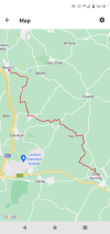
My trip to the North East over the last bank holiday weekend saw me walking from Blyth towards Whitley Bay, mainly along the old Blyth branchline to Newsham, followed by an old Colliery railway route towards Hartley followed by some road walking before the Avenue Branchline towards Monkseaton. Just over 10 miles. The Saturday was another old railway line day with Jarrow towards Dunston, starting with the Bowes Railway Path towards Marley Hill where it turned into the Tanfield Railway Path [alongside the heritage line for a short section] before the run towards Dunston via the beautiful Watergate Forest Park. At Dunston I switched to the Teams Cycleway [which uses another old railway part] before heading into Newcastle station.
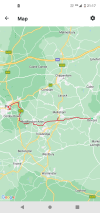
Last weekend on Friday I decided to walk from Wakefield to Dewsbury (saved waiting round for a bus!) along the Calder and Hebble Navigation, not the easiest to reach at the Wakefield end, but did feature walking inside a railway bridge [over the Calder with the Barnsley - Wakefield line]. A nice canal walk, timing it right with the fading light. The Sunday was from Dewsbury towards Huddersfield, a mix of the River Calder, the canal but onto some old railway lines, I believe the former Midland Line from Mirfield towards Huddersfield, labelled as Calder Valley Way from Mirfield & Birkby Bradley Greenway. A couple of points the railway upgrade work forced detours due to the path being closed. Nice viaduct over the Huddersfield Canal. Although it means the next time I stay in Dewsbury I will probably have to take a bus or train somewhere to start a walk as I've done the main routes!
What happened in Semington with that little detour north? [Somerset Arms in the village used to be good from when I was a kid]
------
My trip to the North East over the last bank holiday weekend saw me walking from Blyth towards Whitley Bay, mainly along the old Blyth branchline to Newsham, followed by an old Colliery railway route towards Hartley followed by some road walking before the Avenue Branchline towards Monkseaton. Just over 10 miles. The Saturday was another old railway line day with Jarrow towards Dunston, starting with the Bowes Railway Path towards Marley Hill where it turned into the Tanfield Railway Path [alongside the heritage line for a short section] before the run towards Dunston via the beautiful Watergate Forest Park. At Dunston I switched to the Teams Cycleway [which uses another old railway part] before heading into Newcastle station.
Last weekend on Friday I decided to walk from Wakefield to Dewsbury (saved waiting round for a bus!) along the Calder and Hebble Navigation, not the easiest to reach at the Wakefield end, but did feature walking inside a railway bridge [over the Calder with the Barnsley - Wakefield line]. A nice canal walk, timing it right with the fading light. The Sunday was from Dewsbury towards Huddersfield, a mix of the River Calder, the canal but onto some old railway lines, I believe the former Midland Line from Mirfield towards Huddersfield, labelled as Calder Valley Way from Mirfield & Birkby Bradley Greenway. A couple of points the railway upgrade work forced detours due to the path being closed. Nice viaduct over the Huddersfield Canal. Although it means the next time I stay in Dewsbury I will probably have to take a bus or train somewhere to start a walk as I've done the main routes!
Attachments
THC
Member
Splitting at Pewsey gives you 15 miles from Hungerford and 13 miles onto Devizes, a sensible choice.I need to do Hungerford to Devizes of the K&A, will most likely split it at Pewsey. Not sure with the section from Bath to Bristol, if it's 19 miles then it's doable in one day for me (that is one part I haven't really researched)
What happened in Semington with that little detour north? [Somerset Arms in the village used to be good from when I was a kid]
The detour at Semington was because the Somerset Arms is now closed and one of the lads was hungry, so we went and found a Greggs of all things on a Melksham industrial estate. So much for rural isolation on the K&A!
THC
Birmingham
Member
Excellent stuff. I dearly love the K&A, it’s one of my favourites with its impressively rural feel passing through some lovely towns en route.Hungerford to Bristol, 73 miles over 3 days:
Hungerford to Devizes, 28 miles. Day 1 of 3 on the Kennet and Avon Canal towpath towards Bristol and a windy but mainly dry day to start. The highlight was feeding cheese and onion crisps to a pub chicken who then decided I was her new BFF. Cute.
Devizes to Bath, 26 miles. Day 2 of 3 on the Kennet and Avon Canal towpath where I was joined by a couple of old friends from my university days. A cloudy morning gave way to a beautifully sunny afternoon which lit up Bath spectacularly for our arrival.
Bath to Bristol, 19 miles. Day 3 of 3 and onto the River Avon Trail to finish. A very different walking experience to the K&A - the countryside opened out on leaving Bath but narrowed again as we neared Bristol. A couple of pints at Hanham made the last few miles an altogether easier proposition as after 70 miles my feet were rather sore!
THC
johnnychips
Established Member
A poster in this thread - sorry I can’t find the post, but thanks! - recommended the Brampton Valley Trail along the disused railway from Northampton to Market Harborough, and I did it today.
Northampton is a bit of a pig, and expensive, to get to from Sheffield by train, so I got a day return to Leicester then the Stagecoach X7 bus for £2. The walk out of Northampton (which seems rather run down) starts promisingly through a small park, but then there is a couple of miles through a housing estate. In future, I would take the 31 bus to avoid this.
Soon you come to the Northampton and Lamport Railway, which seems to have built an extension, but unfortunately only runs on Sundays and Bank Holidays. However, there was a 31, a 47 which a man was lovingly filling and sanding, and surprisingly a few Mk 3s and a DVT.
There are elements of ‘a long lane that has no turning’ on the route, but with the hawthorn and cow-parsley in blossom, it was delightful. I had forgotten that there were two tunnels in the second half, and these were great as they were unlit, so it was literally looking for the light at the end of the tunnel.
Finally to Market Harborough, after 19 miles in six-and-a-half hours, where a huge sign on crossing the river said ‘Beer House’, so a nice pint of brown ale I’d never heard of and a £2 X7 back to Leicester.
I did this walk a couple of years ago. A damn fine walk and well worth making the effort.A poster in this thread - sorry I can’t find the post, but thanks! - recommended the Brampton Valley Trail along the disused railway from Northampton to Market Harborough, and I did it today.
Northampton is a bit of a pig, and expensive, to get to from Sheffield by train, so I got a day return to Leicester then the Stagecoach X7 bus for £2. The walk out of Northampton (which seems rather run down) starts promisingly through a small park, but then there is a couple of miles through a housing estate. In future, I would take the 31 bus to avoid this.
Soon you come to the Northampton and Lamport Railway, which seems to have built an extension, but unfortunately only runs on Sundays and Bank Holidays. However, there was a 31, a 47 which a man was lovingly filling and sanding, and surprisingly a few Mk 3s and a DVT.
There are elements of ‘a long lane that has no turning’ on the route, but with the hawthorn and cow-parsley in blossom, it was delightful. I had forgotten that there were two tunnels in the second half, and these were great as they were unlit, so it was literally looking for the light at the end of the tunnel.
Finally to Market Harborough, after 19 miles in six-and-a-half hours, where a huge sign on crossing the river said ‘Beer House’, so a nice pint of brown ale I’d never heard of and a £2 X7 back to Leicester.
I took the bus from Northampton town centre to Kings Heath where the Market Harborough line diverges from the main Northampton loop line.
While out hiking in rural East Sussex (one of my favourite areas in the entire world let alone the UK), I came across this...

A 16T mineral wagon in the middle of a rural field. There's never been any industry in this area. The field is about 3 miles from the Hastings Line & around 150m in height! Had to double take!
A 16T mineral wagon in the middle of a rural field. There's never been any industry in this area. The field is about 3 miles from the Hastings Line & around 150m in height! Had to double take!
Kite159
Veteran Member
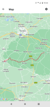
Yesterday I made the most of the sunshine to walk the 18 and a bit miles from Shawford towards Southampton following the long distance Itchen Way to Sholding Station. Footpath was busy in places with other walkers but also quite narrow in places (bit of stop/start due to being single file made worse with the weeds growth). Decent condition underfoot, couple areas of mud with some erosion (definitely one not to do during winter months).
Section from Bishopstoke towards Southampton where it followed the remains of the Itchen Navigation was interesting with the old canal (and very quiet due to being a long section with hardly any breakout points.
A highlight was the section where it followed the Shoreburs Greenway from the Weston waterfront to Sholding. After Sholding I walked across the Itchen Bridge (something which had been on my list to do for years) and across the city to reach the station (via a new Tesco Express outside Southampton Central which I didn't know existed).
Also when in the Bitterne Park area I took a spin on the mini railway (Riverside Park Railway)