Nottingham59
Established Member
Thanks, Yorkie.Reopened to enable @Nottingham59 to post an update
When searching for the latest HS2 business case documentation, I found this from the DfT:
HS2 Phase 2b Western Leg Crewe - Manchester Supplement to the Update on the SOBC

HS2 Crewe to Manchester: impacts of removing the Golborne Link
Supplement to the update on the strategic outline business case.
On page 5, it has a map of the proposed route to Marsden.

I think this line is taken from an actual map, because it is not a smooth curve, but has wiggles in it like the wiggles around Warrington which correspond to the curves on the actual known alignment.
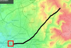
So using the stations at Piccadilly, Wigan NW and Warrington BQ to locate the map, I could overlay the proposed Marsden route onto openrailwaymap to get this:

The registration is not perfect, so the line could be easily out by 1km or so. But it seems consistent with what we know already from posts #80 and #81 above, to give the following route:
- Western portal at the aggregates site between Bessemer Street and Clayton Lane South next to the line from Ashbury to Gorton
- Ventilation shafts at Openshaw, Ashton Moss and Waterloo
- Crossing the river Tame near Dobcross
- Joining the existing railway alignment just north of Diggle
- Then paralleling the existing Standedge tunnels
The furthest point on the map is suspiciously parallel to the existing Standedge tunnels, which makes me think that they plan to use one of the spare bores rather than dig a new alignment with less well understood geology.
What do others think?
If it helps, this is the same map laid over topographic-map.com to show the land forms, if that helps. Red is high ground; green is low. Note the registration is less good on this layout.