• Our new ticketing site is now live! Using either this or the original site (both powered by TrainSplit) helps support the running of the forum with every ticket purchase! Find out more and ask any questions/give us feedback in this thread!

Crossrail - Construction updates and progress towards opening (now expected 24 May 2022)

Status
Not open for further replies.
Joined
22 Jun 2013
Messages
509
I'm flying from Heathrow tomorrow and no route finder, including TfL, City Mapper & Moovit, includes TfL Rail from Paddington, instead I'm directed to the very pricey HX! Anyone know why TfL Rail is omitted?
 
Sponsor Post - registered members do not see these adverts; click here to register, or click here to log in
R

RailUK Forums

Adoarable

Member
Joined
24 Jul 2020
Messages
65
Location
London
I'm flying from Heathrow tomorrow and no route finder, including TfL, City Mapper & Moovit, includes TfL Rail from Paddington, instead I'm directed to the very pricey HX! Anyone know why TfL Rail is omitted?
Probably because those route finders either don't calculate fares or don't use it when generating routes. In which case Heathrow Express will always be prioritised over TfL Rail because it's quicker and no less convenient (until Elizabeth Line through running happens this/next year).

In the TfL journey planner, click 'Edit preferences' then uncheck 'National Rail'. You should be able to see TfL Rail options then.
 

DynamicSpirit

Established Member
Joined
12 Apr 2012
Messages
8,962
Location
SE London
What an utter monstrosity of a map. There's no way Croydon Tramlink should be on it - it's a tram, not a tube or a train. The selective inclusion of some rail lines but not others has little rationale, and makes it look like you'd need to go on a very long tube journey to get from Waterloo to Vauxhall, Clapham Junction, or Wimbledon. And then you have the absurdity of showing the North Kent line, but missing out Woolwich Dockyard, Belvedere and Erith stations (presumably because Thameslink trains don't stop there).

And I know geography gets skewed on the diagrammatic maps, but showing it as if Abbey Wood is within walking distance of Shortlands???? And the GWR lines turning North after Hayes and Harlington to end at Reading, which is just a short distance away from Uxbridge? Really????
 

Watershed

Veteran Member
Associate Staff
Senior Fares Advisor
Joined
26 Sep 2020
Messages
14,172
Location
UK
What an utter monstrosity of a map. There's no way Croydon Tramlink should be on it - it's a tram, not a tube or a train. The selective inclusion of some rail lines but not others has little rationale, and makes it look like you'd need to go on a very long tube journey to get from Waterloo to Vauxhall, Clapham Junction, or Wimbledon. And then you have the absurdity of showing the North Kent line, but missing out Woolwich Dockyard, Belvedere and Erith stations (presumably because Thameslink trains don't stop there).

And I know geography gets skewed on the diagrammatic maps, but showing it as if Abbey Wood is within walking distance of Shortlands???? And the GWR lines turning North after Hayes and Harlington to end at Reading, which is just a short distance away from Uxbridge? Really????
It was originally designed to show TfL services but became messier when Thameslink was added back in. Allegedly that was only for the duration of the Bank upgrade works, but it looks like it's stayed. Personally I'd say the only two maps worth having are a central London map, made large enough for the various interchanges etc. to be clearly visible, and a Rail & Tube map showing everything. Unfortunately the latter isn't ideal either, being quite ambiguous about the fact that contactless is now valid to all of the Thames Valley branches, but not beyond Reading.
 

Horizon22

Established Member
Associate Staff
Jobs & Careers
Joined
8 Sep 2019
Messages
9,446
Location
London
It was originally designed to show TfL services but became messier when Thameslink was added back in. Allegedly that was only for the duration of the Bank upgrade works, but it looks like it's stayed. Personally I'd say the only two maps worth having are a central London map, made large enough for the various interchanges etc. to be clearly visible, and a Rail & Tube map showing everything. Unfortunately the latter isn't ideal either, being quite ambiguous about the fact that contactless is now valid to all of the Thames Valley branches, but not beyond Reading.

I’d say the latter point isn’t an issue considering all those branches are “within” Reading.
 

Watershed

Veteran Member
Associate Staff
Senior Fares Advisor
Joined
26 Sep 2020
Messages
14,172
Location
UK
I’d say the latter point isn’t an issue considering all those branches are “within” Reading.
Perhaps we're talking at cross-purposes, as I was referring to the Rail & Tube map on this point.

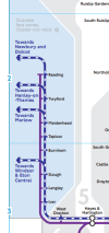
The Thames Valley branches' stations aren't listed on the map and yet contactless is valid there. The arrow just says "towards Windsor & Eton Central" for example:

1652996941592.png

So how is anyone supposed to know that it's OK to use contactless to Windsor, but not Didcot? It's very ambiguous. The arrow towards Newbury and Didcot doesn't even go outside of the map, as most of the others do.
 

Peter Sarf

Established Member
Joined
12 Oct 2010
Messages
7,751
Location
Croydon
What an utter monstrosity of a map. There's no way Croydon Tramlink should be on it - it's a tram, not a tube or a train. The selective inclusion of some rail lines but not others has little rationale, and makes it look like you'd need to go on a very long tube journey to get from Waterloo to Vauxhall, Clapham Junction, or Wimbledon. And then you have the absurdity of showing the North Kent line, but missing out Woolwich Dockyard, Belvedere and Erith stations (presumably because Thameslink trains don't stop there).

And I know geography gets skewed on the diagrammatic maps, but showing it as if Abbey Wood is within walking distance of Shortlands???? And the GWR lines turning North after Hayes and Harlington to end at Reading, which is just a short distance away from Uxbridge? Really????
I would favour keeping Croydon Tramlink on the map as it is quite a significant TfL service. It runs for quite a distance from Croydon to Wimbledon and the other lines also mainly link into rail lines. So it forms an important link between railway lines across South London. It is a lot more than a set of bus routes, sits better with rail than bus and it is largely off road.

But yes, the presentation of Crossrail is rather poor.
 

Egg Centric

Established Member
Joined
6 Oct 2018
Messages
1,861
Location
Land of the Prince Bishops
Is there any chance the barriers quietly open on Monday 23rd?

Precisely what I've been wondering.

I'm down for the Sunderland game on Saturday but then the next week working at my company's HQ in Watford with basically my main "out of hours" objective to ride this thing ASAP - the launch on a Tuesday of all days was very suspicious. Will be keeping an eye out. Would like the input of e.g. @geofftech on things like this...
 

AlbertBeale

Established Member
Joined
16 Jun 2019
Messages
3,188
Location
London
What an utter monstrosity of a map. There's no way Croydon Tramlink should be on it - it's a tram, not a tube or a train. The selective inclusion of some rail lines but not others has little rationale, and makes it look like you'd need to go on a very long tube journey to get from Waterloo to Vauxhall, Clapham Junction, or Wimbledon. And then you have the absurdity of showing the North Kent line, but missing out Woolwich Dockyard, Belvedere and Erith stations (presumably because Thameslink trains don't stop there).

And I know geography gets skewed on the diagrammatic maps, but showing it as if Abbey Wood is within walking distance of Shortlands???? And the GWR lines turning North after Hayes and Harlington to end at Reading, which is just a short distance away from Uxbridge? Really????

I think there's a case for something pared down to be more like the old tube map, for simplicity, as well as an "all London rail" map.

For the former...

It seems to me that both the Thameslink core and the Crossrail core (plus I suppose up to around the Greater London boundary - except Thameslink in the south after it divides too many ways) perform an Underground-like function (as per RER in Paris), with trains every few minutes and going through the centre of London, and it makes sense to include them on the Underground map, though as a separate "mode". Also, DLR - and perhaps Croydon Trams - are tube-like enough to be on the Underground map. I used to think that the Overground made sense in this context too - at least when it was mostly the original routes looping through the inner suburbs - as one more mode. But with some radial NR routes - seemingly arbitrarily - being re-designated as Overground, they're cluttering up the tube map too much now.
 

ijmad

Established Member
Joined
7 Jan 2016
Messages
1,830
Location
UK
Precisely what I've been wondering.

I'm down for the Sunderland game on Saturday but then the next week working at my company's HQ in Watford with basically my main "out of hours" objective to ride this thing ASAP - the launch on a Tuesday of all days was very suspicious. Will be keeping an eye out. Would like the input of e.g. @geofftech on things like this...
It seems like originally they expected to open on Tuesday 17th, after the Queen's visit and official ribbon cutting on Monday 16th.

The opening got pushed back a week but they couldn't push back the Queen...
 

Basil Jet

On Moderation
Joined
23 Apr 2022
Messages
1,090
Location
London
It seems like originally they expected to open on Tuesday 17th, after the Queen's visit and official ribbon cutting on Monday 16th.

The opening got pushed back a week but they couldn't push back the Queen...
When someone is in their 90s, delaying them a week isn't advisable even if they're okay with it.
 

jumble

Established Member
Joined
1 Jul 2011
Messages
1,261
+ Oyster Ticket Stops in Zone 1, TfL Visitor Centres, at Heathrow stations, and Elizabeth line stations from Paddington - Abbey Wood, Paddington - West Drayton and Liverpool Street - Brentwood.
Thanks
I got 2 yesterday from the LUL machines at Liverpool St
( A kind CSA was extremely helpful in telling me which machines had them in and which did not)
 

Adoarable

Member
Joined
24 Jul 2020
Messages
65
Location
London
The Rail&Tube map has been updated too.

Highlights:
- On this map (as opposed to the Tube map), Elizabeth is solid purple. Which is great except it's quite similar in colour to the Piccadilly line, which it crosses at a skew angle.
- The interchange at Moorgate has been omitted. Presumably this helps with simplicity but it does hide the connection for Northern and Northern City Line passengers.
 

Intro298

Member
Joined
21 Jul 2021
Messages
51
Location
London
Precisely what I've been wondering.

I'm down for the Sunderland game on Saturday but then the next week working at my company's HQ in Watford with basically my main "out of hours" objective to ride this thing ASAP - the launch on a Tuesday of all days was very suspicious. Will be keeping an eye out. Would like the input of e.g. @geofftech on things like this...
I will certainly be keeping my eye out on Monday, especially considering the early reopening of the Bank branch.
 

DynamicSpirit

Established Member
Joined
12 Apr 2012
Messages
8,962
Location
SE London
I would favour keeping Croydon Tramlink on the map as it is quite a significant TfL service. It runs for quite a distance from Croydon to Wimbledon and the other lines also mainly link into rail lines. So it forms an important link between railway lines across South London. It is a lot more than a set of bus routes, sits better with rail than bus and it is largely off road.

That would be a good argument for including Croydon Tramlink in the Rail-&-Tube map: It makes sense there as a link that connects quite a few of the rail lines in South London.

But the tube map doesn't show (most) rail lines in South London, so there's no point showing something that links those unshown lines.

To my mind, the fact that it's a TfL service is irrelevant. The tube map is branded as, and is (for the most part) a tube map, not a map of TfL services. It doesn't, for example, include TfL bus services.

The real problem with including Tramlink on the tube map is that the tube lines are really focused on central London - so the main utility of a tube map is in showing you how to get around zone 1 (and also now arguably the DLR area). If you're travelling in outer London - especially in South London, then for the most part, you need the rail & tube map - the tube map by itself is almost useless unless you happen to be travelling between destinations along the same tube line. But Tramlink doesn't go anywhere near central London - in fact, its only direct interchange with the tube at all is at Wimbledon. So it's mostly irrelevant to the kinds of journeys for which people will need the tube map. Worse - including it forces a distortion beyond belief of the South London geography on the tube map in order to fit it in. And including it but not the rail lines gives a completely misleading impression of what transport options are available in the Croydon area.

There's perhaps some case for showing the small section between Wimbledon wand Morden Road - just because of the linkage between the District and Northern lines in the area. But including the rest of it on the tube map seems to me to be a political decision that takes no account of the needs of tube map users. Croydon Tramlink should be on the rail-&-tube map, not the tube map.
 

BobSmith833

Member
Joined
8 Nov 2010
Messages
16
I have been saying this for some time. It's probably time to retire the tube-only map altogether, it's not really useful in modern London, in which it's just as easy to travel around by train than by tube and often far more sensible than the options shown on the tube map (e.g. Queen's Road Peckham to London Bridge, Vauxhall to Waterloo etc.). Just give people all the options and let them make their own decisions, rather than arbitrarily including TfL and Thameslink but nothing else.

== Doublepost prevention - post automatically merged: ==

So, regarding the launch of the Liz line... there appear to be two outstanding questions:

1. Will it have a soft opening on the 23rd? Probability is perhaps that it won't, but seems nobody knows for sure.

2. Should enthusiasts go to Paddington or to Abbey Wood if they want to "ride the first train"? According to Geoff Marshall, the first train will actually depart Abbey Wood, by a few minutes, but then again the Paddington one will be the first to enter the new core tunnels. I suspect most people are planning to start at Paddington, but interested to hear what you guys here are actually planning to do...
 

DynamicSpirit

Established Member
Joined
12 Apr 2012
Messages
8,962
Location
SE London
2. Should enthusiasts go to Paddington or to Abbey Wood if they want to "ride the first train"? According to Geoff Marshall, the first train will actually depart Abbey Wood, by a few minutes, but then again the Paddington one will be the first to enter the new core tunnels. I suspect most people are planning to start at Paddington, but interested to hear what you guys here are actually planning to do...

I actually live in Abbey Wood, so the question of where I start is kinda make up for me :)

Personally I'm not that interested in getting on the the very first train. I'd quite like to take a ride at some point on Tuesday to see what it's like, but I'll probably wait till a bit later in the day - when there's actually something open to do in central London once I get there!
 

Horizon22

Established Member
Associate Staff
Jobs & Careers
Joined
8 Sep 2019
Messages
9,446
Location
London
That would be a good argument for including Croydon Tramlink in the Rail-&-Tube map: It makes sense there as a link that connects quite a few of the rail lines in South London.

But the tube map doesn't show (most) rail lines in South London, so there's no point showing something that links those unshown lines.

To my mind, the fact that it's a TfL service is irrelevant. The tube map is branded as, and is (for the most part) a tube map, not a map of TfL services. It doesn't, for example, include TfL bus services.

The real problem with including Tramlink on the tube map is that the tube lines are really focused on central London - so the main utility of a tube map is in showing you how to get around zone 1 (and also now arguably the DLR area). If you're travelling in outer London - especially in South London, then for the most part, you need the rail & tube map - the tube map by itself is almost useless unless you happen to be travelling between destinations along the same tube line. But Tramlink doesn't go anywhere near central London - in fact, its only direct interchange with the tube at all is at Wimbledon. So it's mostly irrelevant to the kinds of journeys for which people will need the tube map. Worse - including it forces a distortion beyond belief of the South London geography on the tube map in order to fit it in. And including it but not the rail lines gives a completely misleading impression of what transport options are available in the Croydon area.

There's perhaps some case for showing the small section between Wimbledon wand Morden Road - just because of the linkage between the District and Northern lines in the area. But including the rest of it on the tube map seems to me to be a political decision that takes no account of the needs of tube map users. Croydon Tramlink should be on the rail-&-tube map, not the tube map.

With Thameslink it would have made more sense if there were just arrows at certain points (maybe beyond Elephant & Castle, London Bridge, West Hampstead & Finsbury Park) but instead the line has shown every branch south of the river which really has added to the mess. I think most people were surprised to see everything on there when the original intention was to show that it is indeed quicker for a Z1 journey London Bridge to St Pancras rather than Northern line and fills a good tube gap.

== Doublepost prevention - post automatically merged: ==

Perhaps we're talking at cross-purposes, as I was referring to the Rail & Tube map on this point.

The Thames Valley branches' stations aren't listed on the map and yet contactless is valid there. The arrow just says "towards Windsor & Eton Central" for example:

View attachment 114996

So how is anyone supposed to know that it's OK to use contactless to Windsor, but not Didcot? It's very ambiguous. The arrow towards Newbury and Didcot doesn't even go outside of the map, as most of the others do.

I take that point. Perhaps the blue line should have ended before that curve towards Newbury & Didcot.
 

BobSmith833

Member
Joined
8 Nov 2010
Messages
16
With Thameslink it would have made more sense if there were just arrows at certain points (maybe beyond Elephant & Castle, London Bridge, West Hampstead & Finsbury Park) but instead the line has shown every branch south of the river which really has added to the mess. I think most people were surprised to see everything on there when the original intention was to show that it is indeed quicker for a Z1 journey London Bridge to St Pancras rather than Northern line and fills a good tube gap.
The same logic applies to the Waterloo to Vauxhall link on SWR though, that's still a zone 1 journey and incredibly frequent. The whole thing is too messy anyway, and attempting to predict what might be useful to customers is a fool's game.
 

Horizon22

Established Member
Associate Staff
Jobs & Careers
Joined
8 Sep 2019
Messages
9,446
Location
London
The same logic applies to the Waterloo to Vauxhall link on SWR though, that's still a zone 1 journey and incredibly frequent. The whole thing is too messy anyway, and attempting to predict what might be useful to customers is a fool's game.

Yes, and also for Southeastern from London Bridge to Charing Cross & Cannon St. It is I agree odd to add one and not another, but the thinking was generally it was to help relieve loadings for Bank blockade. Probably TfL need to have some firm words with GTR and try and 'reclaim' their map. But the whole thing feels like it needs a rethink because otherwise there's so much information, it actual devalues any useful information for the core base of people using it.

I would add though that this conversation has deviated a fair bit from Crossrail / Elizabeth Line opening & we best not get too far off-topic!
 

Mag_seven

Forum Staff
Staff Member
Global Moderator
Joined
1 Sep 2014
Messages
10,910
Location
here to eternity
2. Should enthusiasts go to Paddington or to Abbey Wood if they want to "ride the first train"? According to Geoff Marshall, the first train will actually depart Abbey Wood, by a few minutes, but then again the Paddington one will be the first to enter the new core tunnels. I suspect most people are planning to start at Paddington, but interested to hear what you guys here are actually planning to do...

If you join the Abbey Wood starter you of course will be on the first train to actually enter the core section from outside it, whereas if you join the Paddington starter you are already in the core tunnels.
 

ijmad

Established Member
Joined
7 Jan 2016
Messages
1,830
Location
UK
If you join the Abbey Wood starter you of course will be on the first train to actually enter the core section from outside it, whereas if you join the Paddington starter you are already in the core tunnels.

Abbey Wood is a core station! But yes if you want to be the first paying passengers in the actual tunnels then pick Paddington.
 

ijmad

Established Member
Joined
7 Jan 2016
Messages
1,830
Location
UK
Isn't the core considered to be Paddington to Whitechapel?

Crossrail Central Operating Section (CCOS) which is the 'core' makes up most of the route to be used by Elizabeth line services that is not part of the Network Rail network.
It comprises Westbourne Park Junction to Abbey Wood and also the Shenfield branch up to Pudding Mill Lane junction immediately west of Stratford.
 

Mojo

Forum Staff
Staff Member
Administrator
Joined
7 Aug 2005
Messages
20,851
Location
0035
There's no way Croydon Tramlink should be on it - it's a tram, not a tube or a train.
FWIW the Trams are not a new addition - they have been on it for a few years, ever since the Trams were included on the Service Update boards at stations and online.

the original intention was to show that it is indeed quicker for a Z1 journey London Bridge to St Pancras rather than Northern line and fills a good tube gap.
The Northern line is actually quicker from Kings Cross St Pancras to London Bridge than TLRailUK, with most journeys timetabled for between 10-11 Mins, vs TLRailUK being 14/15 Mins.

When Thameslink was put on the map in January 2021, the accompanying media release said it was temporary, to support social distancing and also due to engineering works associated with the Bank upgrade. "In light of the continuing coronavirus pandemic, and next year’s Northern line closures required to complete the Bank Upgrade works, Thameslink services have been temporarily included on the Tube map to help customers move around the city. This has been a complicated addition to make to the map, but one that we feel will benefit Londoners as part of our work to promote safe, clean and reliable public transport use across the city" is a quote from Julie Dixon at TfL issued at the time.

Isn't the core considered to be Paddington to Whitechapel?
I have not used the term "Core" be used within the context of Crossrail, I believe that is the term used for Thameslink. The Cos (Central Operating Section) is for Crossrail, this goes from Westbourne Park Junction (including the reversing sidings) to Abbey Wood (including Plumstead sidings), and Pudding Mill Lane Junction. This denotes TfL (RfL(I)) as the infrastructure manager as opposed to Network Rail: https://tfl.gov.uk/corporate/publications-and-reports/crossrail-central-operating-section
 
Last edited:

mattdickinson

Member
Joined
14 Nov 2010
Messages
574
Location
Uxbridge
Perhaps we're talking at cross-purposes, as I was referring to the Rail & Tube map on this point.

The Thames Valley branches' stations aren't listed on the map and yet contactless is valid there. The arrow just says "towards Windsor & Eton Central" for example:

View attachment 114996

So how is anyone supposed to know that it's OK to use contactless to Windsor, but not Didcot? It's very ambiguous. The arrow towards Newbury and Didcot doesn't even go outside of the map, as most of the others do.
With the extension of contactless to much of the South East due soon, the London map won't be suitable for indicating the limits of contactless acceptance. There's probably a case for removing the contactless only extensions to Luton Airport and Welwyn from the London map.
 

Watershed

Veteran Member
Associate Staff
Senior Fares Advisor
Joined
26 Sep 2020
Messages
14,172
Location
UK
With the extension of contactless to much of the South East due soon, the London map won't be suitable for indicating the limits of contactless acceptance. There's probably a case for removing the contactless only extensions to Luton Airport and Welwyn from the London map.
It's currently the only resource that indicates where contactless is valid. I agree though, at some point a different map will be needed.
 

subk2010

Member
Joined
18 Feb 2021
Messages
129
Location
Glasgow
TfL Go APP got an update. The icon becomes purple to welcome the opening of Elizabeth Line. Hope they will keep it purple as it’s sometimes confusing to distinguish the TfL App and RATP App.
 

Attachments

  • ED098D8A-EB24-4A23-8DA3-DE8E98B99019.jpeg
    ED098D8A-EB24-4A23-8DA3-DE8E98B99019.jpeg
    304.3 KB · Views: 85
Status
Not open for further replies.

Top