• Our booking engine at tickets.railforums.co.uk (powered by TrainSplit) helps support the running of the forum with every ticket purchase! Find out more and ask any questions/give us feedback in this thread!

Bermondsey dive under open

Status
Not open for further replies.

MarkyT

Established Member
Joined
20 May 2012
Messages
6,257
Location
Torbay
I'm curious to know why the new points from the DSS to the DSF are 50mph and not 60mph. Both pieces of track are parallel and there's plenty of room to have a longer, quicker crossover.

10MPH difference? Maybe they would have put in a 40MPH turnout if they could have got away with it but in signalling that would require approach release or some other complex advance aspect sequence with splitting distants, preliminary route indicators and the like. Where these are close to other junctions it starts to get really complicated. You can't for example have flashing yellow sequences for one signal overlapping with the same system approaching the next one, so you have to choose splitting distants or PRIs. Make all the diverging differentials no more than 10MPH slower than the fastest route and forget all that. You can have free aspect for all routes.
 
Sponsor Post - registered members do not see these adverts; click here to register, or click here to log in
R

RailUK Forums

swt_passenger

Veteran Member
Joined
7 Apr 2010
Messages
31,443
We don't sign it separately to the other lines - it's part of the route. We were all given a brief to look at and that was our only way of 'signing' it as there were no passenger or training trains over it before it opened.

Thanks for confirming what a couple of us suggested would probably happen many weeks ago, in this thread.

It is obviously impossible for drivers to learn the route "practically", because there is no period when both routes are available prior to it being in use by passenger trains. IIRC exactly the same happened with the Reading flyovers, drivers were reported to have had a brief, and a video, and basically got on with it.
 

FOH

Member
Joined
17 Oct 2013
Messages
712
Finally used it this evening, much faster to get away from LBG now.

Not really much difference on the metro lines. The fly under itself is a non-event, indeed much smoother than the sideways movements in the old layout. The problem remains however as you approach New Cross Gate and seemingly the signaller ponders over what to do for a while.

This evening my service left LBG a few seconds early, had a clear run to the fly under and we were still late at NXG.
 

ijmad

Established Member
Joined
7 Jan 2016
Messages
1,810
Location
UK
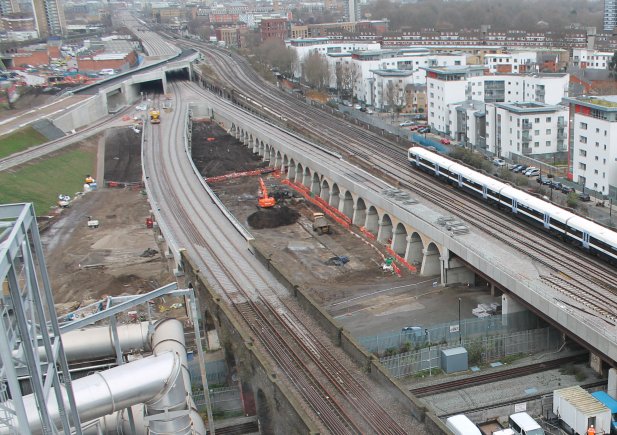
Nice photo on tlprogramme's twitter...

C07KH6YWIAAkG0h.jpg


Link to Tweet

(Note that tweet claims the dive under track is being brought in to use on January 3rd which is obviously wrong as it's in use today, but it's still a nice pic.)
 
Last edited:

hwl

Established Member
Joined
5 Feb 2012
Messages
7,398
When does the SE side open ?

Cheers in advance

Post Easter blockade along with a lot of the other eastern approaches changes.

The loop on track 8 that came out of use when the down sussex slow route through the dive under opened will need to be sorted first as will reconnection at North Kent East Jn.
 

carriageline

Established Member
Joined
11 Jan 2012
Messages
1,897
Post Easter blockade along with a lot of the other eastern approaches changes.


The loop on track 8 that came out of use when the down sussex slow route through the dive under opened will need to be sorted first as will reconnection at North Kent East Jn.


From what I can tell, that is incorrect.

The only changes around Easter are the Cannon St lines go through platforms 1&2, with services still not stopping.

Come august, the Charing Cross side will gain platform 6 (finally!!), and have 3 tracks from Spa Rd ish up to London Bridge. BDU track comes in use.

Then Christmas the Cannon St side gets the same treatment, as well as Thameslink lines.

Note, this is a pretty rough idea of what's happening, it may be slightly different, it's been a while since I've looked at the staging document!


Sent from my iPhone using Tapatalk
 

ijmad

Established Member
Joined
7 Jan 2016
Messages
1,810
Location
UK
I find it interesting there's such a long gap between moving Cannon Street services away from P6 and it coming in to service for CX trains.. I'm sure there's complexity involved but it surprises me!
 

swt_passenger

Veteran Member
Joined
7 Apr 2010
Messages
31,443
I find it interesting there's such a long gap between moving Cannon Street services away from P6 and it coming in to service for CX trains.. I'm sure there's complexity involved but it surprises me!

My suggestions. There is possibly platform edge still to complete because the priority was to run trains through. The signalling is temporary, because the P6 track is presently the logical up Cannon St route and will be signalled for that use, and the signalling logic will be altered to use the future correct route instead. The approach tracks at either end are completely different to the future layout, and the final S&C to connect with the P7 track is possibly still not fully installed.

Regarding the overall timetable, the opening of the single diveunder route for Southern last week took place significantly earlier than the 2014 milestones suggested it would. Earlier posts have also definitely proposed that the next (SE) tracks through the dive under will open sooner than planned, i.e. at Easter. However that turned out to be station changes only - with the lines through the BDU not opening until August.
 
Last edited:

hwl

Established Member
Joined
5 Feb 2012
Messages
7,398
My suggestions. There is possibly platform edge still to complete because the priority was to run trains through. The signalling is temporary, because the P6 track is presently the logical up Cannon St route and will be signalled for that use, and the signalling logic will be altered to use the future correct route instead. The approach tracks at either end are completely different to the future layout, and the final S&C to connect with the P7 track is possibly still not fully installed.

Regarding the overall timetable, the opening of the single diveunder route for Southern last week took place significantly earlier than the 2014 milestones suggested it would. Earlier posts have also definitely proposed that the next (SE) tracks through the dive under will open sooner than planned, i.e. at Easter.

There's hwl posting here: http://www.railforums.co.uk/showpost.php?p=2780553&postcount=137

and here: http://www.railforums.co.uk/showpost.php?p=2640582&postcount=75


2 physical construction (rather than signalling issues):

a) the points on the western approach viaduct allowing access to P6 from the down CHX line haven't been installed yet (see the wooden sleepered section for the location if you look west from P6-9)


b) P5 needs to be completed at the Western end (can't be due to temporary alignment of down CST route until that goes back through P1 etc at Easter). Far easier to do this when line /platform 6 isn't in operation.

Hence both get done between Easter and August.

The corresponding points for P6 on the eastern side were installed in June '16 but are out of use currently.
 

ijmad

Established Member
Joined
7 Jan 2016
Messages
1,810
Location
UK
b) P5 needs to be completed at the Western end (can't be due to temporary alignment of down CST route until that goes back through P1 etc at Easter). Far easier to do this when line /platform 6 isn't in operation.

Makes sense. I'd noticed the slewed arrangement at the western end of P5/6, didn't realise it encroached on what will be the full width of P5, but I can see it now I picture it in my head. I guess it makes for a safer work site for the finishing touches on the P4/5 island too if they don't have trains running over the 5/6 bridge deck.
 

Dr_Paul

Established Member
Joined
3 Sep 2013
Messages
1,359
The opening shot in this video shows a skew arch that seems to have been built either for a road or a railway line: this has intrigued me ever since I first saw it some years back. This map shows the bridge abutments, at 73/18, by the dog kennels (today the rubbish incinerator, the big white building in the film clip). As far as I know, no line ever went through this arch: I've not seen anything on any map.

If it were built for a projected railway line, then where was the line going? At the west end, it would have come off the line coming from Bricklayers Arms and Willow Walk (the southern-most two lines on the six-track viaduct on the map) a little to the west of the map boundary, but this would have meant crossing the East London lines to Peckham (lifted when this map was published) and the west side of New Cross Gate on the flat roughly at 65/23: that's very unlikely. Going south-eastwards, it leads towards the line from the Surrey Docks to New Cross Gate and the South London Line, joining it at around 76/02: this would have allowed a direct if circuitous connection from the latter to the goods depots.

I doubt if it was built for a road: only major roads had this sort of bridge, and there was nowhere for a major road to go here. Minor roads went through the standard viaduct arches.
 

hwl

Established Member
Joined
5 Feb 2012
Messages
7,398
The opening shot in this video shows a skew arch that seems to have been built either for a road or a railway line: this has intrigued me ever since I first saw it some years back. This map shows the bridge abutments, at 73/18, by the dog kennels (today the rubbish incinerator, the big white building in the film clip). As far as I know, no line ever went through this arch: I've not seen anything on any map.

If it were built for a projected railway line, then where was the line going? At the west end, it would have come off the line coming from Bricklayers Arms and Willow Walk (the southern-most two lines on the six-track viaduct on the map) a little to the west of the map boundary, but this would have meant crossing the East London lines to Peckham (lifted when this map was published) and the west side of New Cross Gate on the flat roughly at 65/23: that's very unlikely. Going south-eastwards, it leads towards the line from the Surrey Docks to New Cross Gate and the South London Line, joining it at around 76/02: this would have allowed a direct if circuitous connection from the latter to the goods depots.

I doubt if it was built for a road: only major roads had this sort of bridge, and there was nowhere for a major road to go here. Minor roads went through the standard viaduct arches.

LBSCR Greenland Dock and Deptford Wharf branch which ran under the current "Landmann Way" from the docks to New Cross Gate with connections to both up and down slows. The Up slow connection was a diveunder under the new overground bridge alignment, the down slow connecting ramp can still be seen adjacent to the down slow in places.
 

Chris125

Established Member
Joined
12 Nov 2009
Messages
3,076
I think this is to the west of the docks branch whose arches are now used by a road - this link should show the skewed bridge on 3D google maps.
 

kentman

Member
Joined
10 Jan 2015
Messages
80
The opening shot in this video shows a skew arch that seems to have been built either for a road or a railway line: this has intrigued me ever since I first saw it some years back. This map shows the bridge abutments, at 73/18, by the dog kennels (today the rubbish incinerator, the big white building in the film clip). As far as I know, no line ever went through this arch: I've not seen anything on any map.

If it were built for a projected railway line, then where was the line going? At the west end, it would have come off the line coming from Bricklayers Arms and Willow Walk (the southern-most two lines on the six-track viaduct on the map) a little to the west of the map boundary, but this would have meant crossing the East London lines to Peckham (lifted when this map was published) and the west side of New Cross Gate on the flat roughly at 65/23: that's very unlikely. Going south-eastwards, it leads towards the line from the Surrey Docks to New Cross Gate and the South London Line, joining it at around 76/02: this would have allowed a direct if circuitous connection from the latter to the goods depots.

I doubt if it was built for a road: only major roads had this sort of bridge, and there was nowhere for a major road to go here. Minor roads went through the standard viaduct arches.

If it helps Google Earth has 1945 Aerial photos of London (select view->historical imagery) which are useful to show the OS maps in context with the mired of lines and goods yards in the area at the time. You can see the outline of the dog kennels where the SELCHP is now.

Also useful for seeing the outline of the Dockyard railways which are blank on the OS maps.
 

Deepgreen

Established Member
Joined
12 Jun 2013
Messages
6,394
Location
Betchworth, Surrey
If it helps Google Earth has 1945 Aerial photos of London (select view->historical imagery) which are useful to show the OS maps in context with the mired of lines and goods yards in the area at the time. You can see the outline of the dog kennels where the SELCHP is now.

Also useful for seeing the outline of the Dockyard railways which are blank on the OS maps.


This site may help - I haven't had time to look in detail but it is from 1868.
http://london1868.com/weller70b.htm
 

Chris125

Established Member
Joined
12 Nov 2009
Messages
3,076
NR have uploaded a cabride through the diveunder:

[youtube]KMIBwvnrvqs[/youtube]
 

swt_passenger

Veteran Member
Joined
7 Apr 2010
Messages
31,443
The viaduct with the bridge in question was built much later (around 1905-06) to align with the 4tracking of the Lewisham avoiding route and other capacity improvements.

Just been through all the suitable maps on the "old OS maps" site and can find no period when that skew bridge was in use by a rail route. Joe Brown's London rail atlas doesn't seem to show anything through there either.
 

Dr_Paul

Established Member
Joined
3 Sep 2013
Messages
1,359
The viaduct with the bridge in question was built much later (around 1905-06) to align with the 4tracking of the Lewisham avoiding route and other capacity improvements.

Yes -- I've just been looking at the 25" OS maps and it's on the 1916 one but not on the pre-1900 ones. So if the skew arch on that viaduct was built for a rail line to get into Willow Walk and Bricklayers Arms (and I can't see where else it would have gone), it would have meant that the line would cross the East London Line on the flat, which I find unlikely.

A couple of the lines on the London1868.com map are unlikely, particularly the one on a huge curve from the north-west corner back towards the line to Peckham, which would have meant a fairly complex arrangement around Cold Blow Lane, and which would merely have duplicated the South London Line. I've found that non-OS maps often are rather imaginative when it comes to railways.

I have a feeling that this arch will be one of those minor mysteries that will evade explanation.
 

Deepgreen

Established Member
Joined
12 Jun 2013
Messages
6,394
Location
Betchworth, Surrey
NR have uploaded a cabride through the diveunder:

[youtube]KMIBwvnrvqs[/youtube]

I liked the instant acceleration on passing the 'T' board after the new section!
--- old post above --- --- new post below ---
Yes -- I've just been looking at the 25" OS maps and it's on the 1916 one but not on the pre-1900 ones. So if the skew arch on that viaduct was built for a rail line to get into Willow Walk and Bricklayers Arms (and I can't see where else it would have gone), it would have meant that the line would cross the East London Line on the flat, which I find unlikely.

A couple of the lines on the London1868.com map are unlikely, particularly the one on a huge curve from the north-west corner back towards the line to Peckham, which would have meant a fairly complex arrangement around Cold Blow Lane, and which would merely have duplicated the South London Line. I've found that non-OS maps often are rather imaginative when it comes to railways.

I have a feeling that this arch will be one of those minor mysteries that will evade explanation.

Or perhaps it was intended to join, rather than cross, the ELL?
 

Deepgreen

Established Member
Joined
12 Jun 2013
Messages
6,394
Location
Betchworth, Surrey
I have this 1894-6 image - poor when enlarged but it appears to show a railway running at a shallow angle at least very close to where the skew bridge is.
 

Attachments

  • London-11-NE-1896.jpg
    London-11-NE-1896.jpg
    313 KB · Views: 71

Dr_Paul

Established Member
Joined
3 Sep 2013
Messages
1,359
Or perhaps it was intended to join, rather than cross, the ELL?

At its north-western end, it would have approached the ELL at right-angles, unless it was to turn northwards under the original SER line to New Cross to join the ELL towards its Surrey Docks station. But why have it join the ELL when the south-eastern end of this possible alignment seems to be joining the line from the Surrey Docks/Deptford navy depot branch (I can't see where else it would have gone), which went southwards to both the SLL and New Cross Gate, routes that could be reached from Surrey Docks ELL station already?
 

hwl

Established Member
Joined
5 Feb 2012
Messages
7,398
At its north-western end, it would have approached the ELL at right-angles, unless it was to turn northwards under the original SER line to New Cross to join the ELL towards its Surrey Docks station. But why have it join the ELL when the south-eastern end of this possible alignment seems to be joining the line from the Surrey Docks/Deptford navy depot branch (I can't see where else it would have gone), which went southwards to both the SLL and New Cross Gate, routes that could be reached from Surrey Docks ELL station already?

The Bridge was built by SER and the tracks below would have been LBSCR so it might have been LBSCR playing silly games and claiming they wanted potential access for a small freight (coal) yard just to wind up SER. LBSCr had quite a lot of minor expansion type ideas which never really happen or were stopped if in progress at grouping (e.g. down Streatham Hill Carriage siding enlargement towards Balham which is remarkably undocumented for a big civils job).

Westinghouse Signalling diagrams here for Bricklayers arms and NKE jn but all the other stuff on the Deptford Wharf Branch was ground frame.

http://www.wbsframe.mste.co.uk/public/pdf/Bricklayers_Arms_Junction_1950.01D.PDF

http://www.wbsframe.mste.co.uk/public/pdf/North_Kent_East_1929.43D.PDF
 

Deepgreen

Established Member
Joined
12 Jun 2013
Messages
6,394
Location
Betchworth, Surrey
The Bridge was built by SER and the tracks below would have been LBSCR so it might have been LBSCR playing silly games and claiming they wanted potential access for a small freight (coal) yard just to wind up SER. LBSCr had quite a lot of minor expansion type ideas which never really happen or were stopped if in progress at grouping (e.g. down Streatham Hill Carriage siding enlargement towards Balham which is remarkably undocumented for a big civils job).

Westinghouse Signalling diagrams here for Bricklayers arms and NKE jn but all the other stuff on the Deptford Wharf Branch was ground frame.

http://www.wbsframe.mste.co.uk/public/pdf/Bricklayers_Arms_Junction_1950.01D.PDF

http://www.wbsframe.mste.co.uk/public/pdf/North_Kent_East_1929.43D.PDF

Indeed - the 'spare' bridge spans are still visible close to the junction at Balham.
 

Bald Rick

Veteran Member
Joined
28 Sep 2010
Messages
29,218
A question for regular users of Southern services to London Bridge, particularly drivers.

Have you noticed any improvement in your trips through Bricklayers Arms since the flyover opened, i.e. are more likely to get a good run?

I've just seen TL4444 signal at New Cross Gate go green, twice, in 5 minutes, which is two times more than I have ever seen it green before.
 

Dr_Paul

Established Member
Joined
3 Sep 2013
Messages
1,359
The Bridge was built by SER and the tracks below would have been LBSCR so it might have been LBSCR playing silly games and claiming they wanted potential access for a small freight (coal) yard just to wind up SER. LBSCr had quite a lot of minor expansion type ideas which never really happen or were stopped if in progress at grouping...

Good point! I forgot about the profusion of rival companies in South London and how that might have an influence upon things. I had a look at my copy of A Regional History of the Railways of Great Britain: Greater London (1963 edition), and the attached map from it shows the pre-grouping ownership of lines in that area.
 

Attachments

  • BR Bermondsey 1.JPG
    BR Bermondsey 1.JPG
    107 KB · Views: 43
Last edited:

IKB

Member
Joined
15 Nov 2013
Messages
366
A question for regular users of Southern services to London Bridge, particularly drivers.

Have you noticed any improvement in your trips through Bricklayers Arms since the flyover opened, i.e. are more likely to get a good run?

I've just seen TL4444 signal at New Cross Gate go green, twice, in 5 minutes, which is two times more than I have ever seen it green before.

I had a couple of trips in the up direction on the fast this week. On both occasions was routed over onto the up slow on TL4446 at NXG (single yellow) and then back over onto the Sussex Reversible via a main aspect (red to green) on TL4016. Not sure on the logic there as there was nothing coming down the reversible. Perhaps was just unlucky! The one trip on the up slow had a green on TL4016.

Been in the down direction on the new underpass about four times. The one trip booked to stop on the Down slow at NXG had greens all the way. But the three trains routed through the dive under and onto the down fast encountered reds at TL4023 which cleared to green with junction indicator as you slowed for the single yellow. Is this a case of late route setting...? There was nothing in front as the first to leave LBG for several minutes. Im assuming it doesn't need to be held at red as the crossover is only 10mph lower than linespeed.

Perhaps things are still bedding down.

Edit:
One example of time saving when no longer having to be held in the Up Sussex Loop. Presumably timetables will be amended in due course if the booked layovers are no longer required?
http://www.realtimetrains.co.uk/train/X28473/2017/01/06/advanced
 
Last edited:

hwl

Established Member
Joined
5 Feb 2012
Messages
7,398
A question for regular users of Southern services to London Bridge, particularly drivers.

Have you noticed any improvement in your trips through Bricklayers Arms since the flyover opened, i.e. are more likely to get a good run?

I've just seen TL4444 signal at New Cross Gate go green, twice, in 5 minutes, which is two times more than I have ever seen it green before.

Yes mainly in the down direction probably about a 60 to 90s improvement when everything else is ok. Up is much more of a lottery given potential for late arrival etc., it feels better but harder to quantify as the timetable isn't really optimised for the new layout with reduced pinch points, less congestion but still plenty of padding built in. Not using the Up Loop is good as IKB as pointed out.

It will have been green at odd points in the am peak when they used to attempt to run the 2 up services through at the same time.

[For those less in the know TL4444 is up fast signal at Bricklayers so no surprises for first time green there as all the down services used to run in the down direction on the same line 180m in front].
 
Last edited:
Status
Not open for further replies.

Top