• Our booking engine at tickets.railforums.co.uk (powered by TrainSplit) helps support the running of the forum with every ticket purchase! Find out more and ask any questions/give us feedback in this thread!

[Carto Metro] Glasgow subway detailled track map

Status
Not open for further replies.

carto.metro

Member
Joined
3 Mar 2011
Messages
10
Hello,

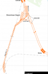
I'm working on a detailed track map of the Glasgow subway:
https://cartometro.com/cartes/metro-glasgow/

It's slightly smaller than London (and i'll not add the NR track for now !) but I still may have made some mistakes.
Also, the extension of the depot is maybe not fully complete ?

Thank you for comments and advice,
Franklin
 
Sponsor Post - registered members do not see these adverts; click here to register, or click here to log in
R

RailUK Forums

Rick1984

Member
Joined
23 Aug 2012
Messages
1,038
Slightly off topic but I love your London Tube map and is actually quite useful for journey planning
 

Rick1984

Member
Joined
23 Aug 2012
Messages
1,038
Something I don't realise before, was that the depot is built on footprint of older railways
 

subk2010

Member
Joined
18 Feb 2021
Messages
129
Location
Glasgow
Lovely! Just the information I need. Thank you!
PS: I am very surprised that there aren't any crossovers except the section between Govan and Ibrox...
 
Last edited:

Lytham Local

Member
Joined
5 May 2017
Messages
83
Something I don't realise before, was that the depot is built on footprint of older railways

Depot and test track was build on the old Govan Branch. Don't know when the Govan branch closed, but the depot was built from 1977 as part of the Glasgow modernisation.
 

the sniper

Established Member
Joined
4 Sep 2007
Messages
3,499
I can't vouch for the accuracy, but it certainly looks great to me! Just to add, your London detailed map is a thing of beauty, thank you for all your continued efforts!

EDIT: Also, Toronto too is a particular favourite, great work.
 
Last edited:

hexagon789

Veteran Member
Joined
2 Sep 2016
Messages
15,801
Location
Glasgow
Depot and test track was build on the old Govan Branch. Don't know when the Govan branch closed, but the depot was built from 1977 as part of the Glasgow modernisation.
Passenger services ended in 1921 although the branch was not formally closed until 1966, the track was lifted in 1970.
 

Ken H

On Moderation
Joined
11 Nov 2018
Messages
6,313
Location
N Yorks
Is it 'drive on the left' so the outer rail is clockwise?
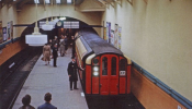
I had a go on the subway late 70's. The cars got lighting power from 2 bars on the tunnel walls. You can see them in this pic (in front of the grey band on the walls)
 

jopsuk

Veteran Member
Joined
13 May 2008
Messages
12,773
Hello,

I'm working on a detailed track map of the Glasgow subway:
https://cartometro.com/cartes/metro-glasgow/

It's slightly smaller than London (and i'll not add the NR track for now !) but I still may have made some mistakes.
Also, the extension of the depot is maybe not fully complete ?

Thank you for comments and advice,
Franklin
this beautiful! "slightly smaller than London" is a lovely bit of understatement
 

swt_passenger

Veteran Member
Joined
7 Apr 2010
Messages
31,448
When it was cable hauled and right up until modernisation in the late-1970s there were no crossovers at all. Both lines were entirely independent.
Indeed, and AIUI the “trains” themselves were one sided, ie they had doors only on one side. I wonder if they swapped them round between inner and outer circuits when lifted out for maintenance?
 

hexagon789

Veteran Member
Joined
2 Sep 2016
Messages
15,801
Location
Glasgow
Indeed, and AIUI the “trains” themselves were one sided, ie they had doors only on one side. I wonder if they swapped them round between inner and outer circuits when lifted out for maintenance?
Surely that would have happened naturally - I wouldn't have thought they would have tried to keep cars on the same circle and didn't they try to even out wheel wear by swapping them between sides anyway?

ISTR that they considered continuing the practice post-modernisation but it was found that the difference in wheel wear was within 5% of the life of the wheels anyway so it wasn't worth deliberately trying to even out use on each circle.
 

carto.metro

Member
Joined
3 Mar 2011
Messages
10
I can add some date details to start explaining evolution around the depot:
1640022262947.png
Obviously, a separate map of the "original" Broomloan Depot with lifts area could be interesting but I don't know if I can find a such information.
 

backontrack

Established Member
Joined
2 Feb 2014
Messages
6,383
Location
The UK
Hello,

I'm working on a detailed track map of the Glasgow subway:
https://cartometro.com/cartes/metro-glasgow/

It's slightly smaller than London (and i'll not add the NR track for now !) but I still may have made some mistakes.
Also, the extension of the depot is maybe not fully complete ?

Thank you for comments and advice,
Franklin
What a wonderful resource! Thank you
 

MotCO

Established Member
Joined
25 Aug 2014
Messages
4,135
Is it 'drive on the left' so the outer rail is clockwise?
I had a go on the subway late 70's. The cars got lighting power from 2 bars on the tunnel walls. You can see them in this pic (in front of the grey band on the walls)

Did you attach the pic?

Indeed, and AIUI the “trains” themselves were one sided, ie they had doors only on one side. I wonder if they swapped them round between inner and outer circuits when lifted out for maintenance?
How does this work when the map appears to show some island platforms and some 'outside' platforms? Or were new platforms constructed when the railway was updated?
 

Taunton

Established Member
Joined
1 Aug 2013
Messages
10,101
How does this work when the map appears to show some island platforms and some 'outside' platforms? Or were new platforms constructed when the railway was updated?
I worked on the project briefly in the 1970s, the station buildings rebuilding! I actually reported to the chief architect on the buildings side and did a few details on the drawings.

Until 1977 every station was a central island platform. Some were notably small and narrow (as a few of the lesser ones still are).

There were no points at all, probably unique for a railway of this scale.

The original depot building is still very much there, on the depot site, here : 12 Broomloan Rd - Google Maps

The scale of the depot, sidings, etc has gone from one extreme to the other. Originally, with no points, everything was lifted on and off with a large crane; the two circles ran through a large pit under the depot, which just had a series of stub tracks for vehicles to be placed on. Everything was contained within the single depot building, the cars never saw daylight. No test track, nothing. I really don't believe there was enough space for all the vehicles on the stub tracks in there, most were left on the running tracks either side of the pit overnight. This was especially an issue towards the end when they had a lot of non-runners and a minimal service. There was an old small paperback book I used to have, probably bought at the old Glasgow transport museum, which I recall had a depot plan and thus showed the various stubs. Nowadays there seems far more siding space than the fleet they have, the new stock seems to have been readily accommodated alongside the 1970s vehicles without issue.

Contrary to much local belief the vehicles were painted the same red all over; one heard many times the old joke that the offside, never visible from a platform, was not painted at all, or painted black. It didn't have the decals applied of course. Towards the end the wooden bodies had really deteriorated, they could be seen to be visibly flexing at the joints as you went along, and I wouldn't have been surprised if the window glass had fallen out.

The old thing about alternate side usage and wheel wear was also not correct, they didn't consciously bother and it was never an issue. The overall curving of the circles was so large radius as to be of no consequence, and there was this complete lack of points and tight turnouts which is what wears squealing wheels the quickest.

We have discussed the old Subway here before here, use the Search. There are also some characteristic YouTube videos. Most of the staff until the 1977 closure, invariably elderly, were ex-Glasgow tramways, which last ran 15 years beforehand in 1962.
 
Last edited:

swt_passenger

Veteran Member
Joined
7 Apr 2010
Messages
31,448
Did you attach the pic?


How does this work when the map appears to show some island platforms and some 'outside' platforms? Or were new platforms constructed when the railway was updated?
Yes, it’s no longer as simple as it was before the major rebuild, as others have since mentioned.
 

Am Broc

Member
Joined
15 Oct 2019
Messages
47
Location
Glaschu / Glasgow
That's an outstanding map! Thanks so much. I like the way it shows where the old Govan (mainline) station was. I had a few walks down there during lockdown trying to work out where it was!
 

Strathclyder

Established Member
Joined
12 Jun 2013
Messages
3,233
Location
Clydebank
An outstanding resource! Gotta love the attention to detail, notably the stations where a additional platform was built flanking the original island one (at Hillhead, Buchanan Street & Ibrox), plus the arrow indicating the direction of travel for said platform. The dotted outline at the stations where two seperate platforms replaced the original island one (Govan & St. Enoch) is... chief's kiss. Keep up the excellent work OP! :)

BTW, that London map is a work of art. :)
 
Status
Not open for further replies.

Top