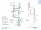
By my counting, North of Crewe there currently are these fast services:
1 tph Glasgow
1 tph Glasgow/Edinburgh via Birmingham
2 tph Liverpool
1 tph Chester/North Wales
1 tph Manchester via Crewe*
2 tph Manchester via Stoke*
2 tph XC Manchester via Stoke*
*different sources disagree on how these are spread, does anyone know for sure?
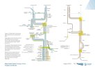
I would turn this into these HS2 services after phase 2A opens:
- 1 tph Glasgow/Edinburgh (split at Carlisle), stopping at Crewe, Preston, Carlisle, and Haymarket
- 1 tph Glasgow/Edinburgh (split at Carlisle) from Curzon street, stopping at Crewe, Preston, Carlisle, and Haymarket
- 2 tph Liverpool, stopping at Birmingham International, Crewe, Runcorn, and Liverpool South Parkway (1tph)
-- 1 tph splitting into a Liverpool and a Carlisle or Blackpool service (with stops), if capacity north of Crewe allows
- 4/5 tph Manchester:
-- 1 tph via Crewe, stopping at Birmingham International, Crewe, as now to Picadilly
-- 3/4 tph via stoke, stopping at Birmingham International, then as now after leaving HS2 at Handsacre
*Passengers on current XC services change at Birmingham International onto HS2 services. If there is capacity for 2 tph via Crewe, instead do this:
- 2 tph HS2 via Crewe, stopping at Birmingham International, Crewe, as now to Picadilly
- 2 tph HS2 via Stoke, stopping at Birmingham International, then as now after leaving HS2 at Handsacre
- 2 tph XC via Stoke, stopping as now
How do you think the optimal service pattern will change? Will that mean that some places will have, for instance, a slower but more frequent service?
Exactly
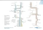
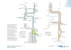
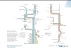
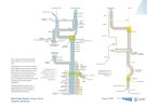
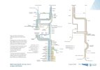
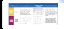
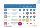
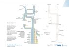
Network rail will have better examples than I could ever come up with!
See the attachments above from the network rail study on post phase 2a services.