Not answering this specific question, but anyone interested in this sort of LT stuff generally might take a look at Harsigs pages :
assuming you don't already know of it.
assuming you don't already know of it.
I found a thread in the District Dave forum earlier, a poster there thought that the brick building standing behind the signal box was built to house the kitchen for the staff cafeteria built within the disused tunnel.This, from the OS 1:1250 plan revised 1962, corresponds to the photo in post #21.
The unrevised on from 1951 (also on NLS) is almost the same, but lacks the funny-shaped building behind the pub and the lineside brick shed. So at that date the route to the tunnel would still have been clear and visible.

 districtdavesforum.co.uk
The 1988 picture (https://www.geograph.org.uk/photo/2815228) may help. It shows the SW corner of the station almost as it would have been in the 1970s, except that the former connection to the Circle Line has been partly demolished for the start of new construction. I think the concrete structure in the left foreground, with the obvious rectangular cut-out, must be the westernmost of the two modern towers at the entrance (https://www.geograph.org.uk/photo/34360), with the steel framework of the new part of the western wall of the station behind it; the high part of that framework must correspond to the gable at the west end of the present-day concourse (https://www.geograph.org.uk/photo/7625682). In the middle distance of the 1988 picture, to the left of the old tower and with 3 arches at the bottom, is the south side of the building under whose north side the former connection can be seen disappearing in the 1920s pictures linked to from post #13.In the 1970s it was very clear where the tracks from platforms 1 and 2 would have gone to connect with the underground, even without the benefit of accessing the canteen (that I have just learned of!). The rebuild of the station has left the features that I remember from those days very difficult to place in the current building.
The GER platforms are slightly higher than the Metropolitan platforms, but not by much. Coming off the eastbound Metropolitan platform there are, if I remember right, three steps up to the LU ticket barriers, and then about seven more from the LU ticket barriers to the GER concourse. The height difference is less than downstairs to upstairs in a house.It's never occurred to me that the platforms at Liverpool Street are below street level, but then, you do have to descend stairs to enter the station, so I suppose it's obvious, when you stop and think about it...
Are the mainline platforms and LU platforms roughly at the same height or would there have been a gradient in the tunnel to connect the two?
It was - the main platforms extended under the hotel and allowed supplies to the hotel to be delivered by rail right to its goods entrance.Thanks a lot all, very interesting for me to see all this! That 1895 plan of the station makes it look like it was basically totally cut in half by those long tracks right in the middle!
Maybe for signalled passenger operations. I came down onto the Inner Rail platform one weekday in what must have been 1982 or later, and there was Sarah Siddons, the Met's historic electric loco, parked in the bay.The disused bay at Liverpool St was on the right in that view, ie behind the westbound platform. It’s all been hidden by new building during the Crossrail alterations.
I found an earlier YouTube cab view from 1989, the bay platform was unusable by then, (I read since 1981)
As others describe, it long stayed like that. The major Liverpool Street pedestrian entrance from Bishopsgate is above the tracks, and a high level walkway, still somewhat there in the new layout, was the principal walking route to the West Side low numbered platforms, including booking office windows and passing over the tracks of the middle platforms 9 and 10. Originally these tracks had extended beyond the later bufferstops to beneath the hotel, and were used for wagonloads of coal in and rubbish out for that establishment. These platforms were of course used for the longest trains, Norwich expresses and the Harwich boat trains.Thanks a lot all, very interesting for me to see all this! That 1895 plan of the station makes it look like it was basically totally cut in half by those long tracks right in the middle!
Wikipedia has a plan of the station before the 1890s extension: https://commons.wikimedia.org/wiki/...l_Street_and_Broad_Street_stations_(plan).jpg. Note that it includes Broad Street next door (whose platforms were well above street level). 'Suburban Approach' indicates the roadway under which the Met connection ran.The long platforms were originally the easternmost pair - the arrivals platform being separated from the rest of the station didn't matter as arriving passengers would be expected to pass straight through and have no need for facilities such as booking office or waiting rooms. However, as the site was constrained to the west by the presence of Broad Street station, expansion in the 1890s could only be to the east, leaving the long platforms inconveniently in the middle of the expanded station.
When I first worked at Liverpool Street (1982) I used to occasionally use the canteen which was operated by LT. It was a very gloomy place mostly used by bus crews and Underground staff, Smokey and it sold alcohol! From memory (now over 40 years ago) the food wasn’t very good though, certainly not compared to Stevenson Rooms at from when I moved back to BR Euston which was a different world in so many ways!In the early 1980s my Dad worked in BR offices at Liverpool St. On visiting him one day during a school holiday, we went to the station's subterranean staff canteen for lunch and he explained the unusual curved shape and arched roof of the room was due to its location in the old connecting tunnel. This was shortly before the huge Broadgate redevelopment and associated works at Liverpool St station. I don't know if any remnants survive today.

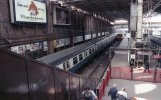
Absolutely fascinating that pdf. The old posters that were just left and wiring laid across them.I found a decent photo on Flickr from 1982, although looking to the west, it clearly shows the curve of the early brick buildings at street level, please compare with the OS map extract in post #6 above.
Even by 1982 there were small brick buildings hiding the route of the curve, it would be quite difficult to see from a passing train:
Liverpool Street (Met) by Kevin Lane, on Flickr
Now, Ive found a good description of the route and its history in a Crossrail learning legacy “built heritage” report. They use the name Queen Victoria Tunnel, and there’s a layout on the pdf page 6 and a one page summary of the tunnel’s use on pdf page 31. The last use was apparently in 1907:
Most likely. IIRC, Liverpool Street was built after the Met, and was built at a lower level partly to facilitate the connection. Looking at the alignment of the tunnel, it avoided the front of Broad Street station and ran under the road, the old suburban entry ramp, booking office and finally concourse.I'm assuming it was a cut and cover tunnel?
Earlier posts suggested that the Met used this curve to terminate in the main line station before their own was ready, which suggest the main line station was there first.Most likely. IIRC, Liverpool Street was built after the Met, and was built at a lower level partly to facilitate the connection. Looking at the alignment of the tunnel, it avoided the front of Broad Street station and ran under the road, the old suburban entry ramp, booking office and finally concourse.
It's interesting to speculate that the Metropolitan Railway might have become a cross-London line if their desired connection via Liverpool Street to Whitechapel and the East London Line had come about. The GER wouldn't allow Met trains to cross their entire main line throat to get to Shoreditch, but a new ramp up and over the main line through Bishopsgate Goods might have worked. The Met could also join the ELR via St Mary's curve near Whitechapel, but that involved interrunning with District services on the busy section east of Aldgate. Passenger services via that connection finished in 1939 though it was retained for empty stock transfers until final closure as part of the LO conversion.Earlier posts suggested that the Met used this curve to terminate in the main line station before their own was ready, which suggest the main line station was there first.
Something I wonder is whether a connection from the Met onto the GER on other (south/east) side of Liverpool Street, i.e. on the optimum side for a link to Whitechapel and the ELR, would have been practicable, had it been done at construction time.It's interesting to speculate that the Metropolitan Railway might have become a cross-London line if their desired connection via Liverpool Street to Whitechapel and the East London Line had come about. The GER wouldn't allow Met trains to cross their entire main line throat to get to Shoreditch, but a new ramp up and over the main line through Bishopsgate Goods might have worked. The Met could also join the ELR via St Mary's curve near Whitechapel, but that involved interrunning with District services on the busy section east of Aldgate. Passenger services via that connection finished in 1939 though it was retained for empty stock transfers until final closure as part of the LO conversion.
Such a route already existed, albeit with reversal, until the northern end of the ELR was disconnected at Shoreditch.Something I wonder is whether a connection from the Met onto the GER on other (south/east) side of Liverpool Street, i.e. on the optimum side for a link to Whitechapel and the ELR, would have been practicable, had it been done at construction time.
To clarify, my thought is over a curve running just of Liverpool Street Met Stn round to the east of Liverpool Street GER station (matching that on the side of Liverpool St GER, that did exist and we have been discussing), permitting direct access from the ELR at Whitechapel, through Shoreditch, Liverpool St GE, onto the Met/Circle at Liverpool St Met, and to Moorgate and beyond.Such a route already existed, albeit with reversal, until the northern end of the ELR was disconnected at Shoreditch.
There was a curve at Whitechapel that allowed this via Aldgate, connecting all stations except Whitechapel (connected to Moorgate etc by other services) and Shoreditch.To clarify, my thought is over a curve running just of Liverpool Street Met Stn round to the east of Liverpool Street GER station (matching that on the side of Liverpool St GER, that did exist and we have been discussing), permitting direct access from the ELR at Whitechapel, through Shoreditch, Liverpool St GE, onto the Met/Circle at Liverpool St Met, and to Moorgate and beyond.
Sorry, I wasn't clear. The Met existed first, but terminated at Moorgate. I believe that they extended to Liverpool Street when it was built, and as plans and corporate politics changed, very quickly decided to head for Aldgate instead, possibly related to parliament's insistence on completing the Circle line to ensure that as much of the mileage was theirs rather than the District's.Earlier posts suggested that the Met used this curve to terminate in the main line station before their own was ready, which suggest the main line station was there first.
I can definitely recollect a journey on the Circle Line, possibly in the late 50s, when the tunnel entrance was visible. Perhaps it was just before the construction of the kitchen. I only saw it once, briefly while the train was passing, but the tunnel itself was well-lit and I could see it curving away. I looked out for it on subsequent occasions by which time the entrance was obscured by the building.I found a thread in the District Dave forum earlier, a poster there thought that the brick building standing behind the signal box was built to house the kitchen for the staff cafeteria built within the disused tunnel.
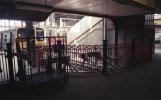
The connection ran behind the signalbox, I.e. the signalbox is in the V of the junction - which it controlled. If you look left as you approach L Street from Moorgate you can see the wall built across the connecting tunnel (or you could when I was last there a few years ago).I found a decent photo on Flickr from 1982, although looking to the west, it clearly shows the curve of the early brick buildings at street level, please compare with the OS map extract in post #6 above.
Even by 1982 there were small brick buildings hiding the route of the curve, it would be quite difficult to see from a passing train:
Now, Ive found a good description of the route and its history in a Crossrail learning legacy “built heritage” report. They use the name Queen Victoria Tunnel, and there’s a layout on the pdf page 6 and a one page summary of the tunnel’s use on pdf page 31. The last use was apparently in 1907:
The easetrn platfofrms at Liverpool Street were only added in the 1890s. Until then the easternmost platforms were the two long ones which extended under the hotel, close to and roughly at right angles to the Met stationSomething I wonder is whether a connection from the Met onto the GER on other (south/east) side of Liverpool Street, i.e. on the optimum side for a link to Whitechapel and the ELR, would have been practicable, had it been done at construction time.
I think we had confirmed that with the OS map in post #6? The aim of my Flickr linked photo was to show how the original brick buildings curved to match the track alignment, before the more modern concrete builds had mostly obscured the view.The connection ran behind the signalbox, I.e. the signalbox is in the V of the junction - which it controlled. If you look left as you approach L Street from Moorgate you can see the wall built across the connecting tunnel (or you could when I was last there a few years ago).