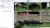
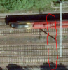
I doubt that the plane flies back and forth photographing the same area again and again surely that would be a waste of resources..
Usually, in vertical aerial photography that's exactly what happens.
The aircraft flies a fixed, straight and level course then returns in the opposite direction covering the next adjacent strip, usually with a 60% overlap both in each individual photographs and in the strips covered.
The large overlap is essential for two reasons; firstly, the photographs are often required as stereo pairs but, when turned into a flat map the individual photographs need to be 'rectified' to remove distortions due to variations in distance from the camera; the edges of the photographs are further away from the camera and land height differences cause a change of scale. The more overlap you have, the easier it becomes to join your photographs but, over the large areas that Google have at large scale there are still going to be minor distortions.
My guess with this one is that the plane was indeed flying almost parallel with the line and the front and rear of it just happened to be on adjacent photos nicely positioned to sit just where whatever software the mappers use decided to make a join.
Unlikely perhaps, but that sort of coincidence is bound to happen somewhere if you take enough large scale images.