• Our booking engine at tickets.railforums.co.uk (powered by TrainSplit) helps support the running of the forum with every ticket purchase! Find out more and ask any questions/give us feedback in this thread!

Nuneham Viaduct shut - Didcot- Oxford

Status
Not open for further replies.

hwl

Established Member
Joined
5 Feb 2012
Messages
7,401
Maybe I've misunderstood. I thought intention was temporary prop structure to be open by 9th June so they can properly fix the issues with the embankment. I may very well be wrong.
The long term solution is apparently to replace the current 2 span bridge decks with a single span with no central support in the river (which may also run into scour or subsidence issues at some point).

The river and railway structure aren't perpendicular making structures more vulnerable to turbulence and scour.
 
Sponsor Post - registered members do not see these adverts; click here to register, or click here to log in
R

RailUK Forums

jimm

Established Member
Joined
6 Apr 2012
Messages
5,231
How? Bridge is north of Culham. Not many passengers though, only the few for UKAEA/JET Culham Lab
I doubt an all-day service is envisaged between Didcot and Culham but there are decent passenger numbers in the peaks, mostly people working at the science centre - though not on a par with the Oxford-Culham flow in normal times.

With both the rail replacement buses via Appleford and the Thames Travel No 95 via a couple of other villages both taking 25 to 30 minutes for a trip that a train manages in 5 or 7 minutes, depending on whether it makes an Appleford call, I'd imagine anyone living in Didcot or beyond who has access to a car is driving to work at the moment, which is probably not going down well in the villages they will all be driving through, due to the limited number of bridges over the river around there.
 

Nicholas43

Member
Joined
16 Jun 2011
Messages
514
The long term solution is apparently to replace the current 2 span bridge decks with a single span with no central support in the river (which may also run into scour or subsidence issues at some point).
Really? When?
The river and railway structure aren't perpendicular making structures more vulnerable to turbulence and scour.
It would be rather remarkable if they were perpendicular! Actually, the railway track is nearly at a right angle to the river.

Meanwhile, this morning (Saturday 22 April) near the bank, just downstream of the bridge, there were the tops of 3 pairs of tubes apparently piled into the river bed. And two huge rafts, one for moving stuff around, and one moored just upstream of the bridge, with a big digger on it, fitted with a piling bashing thingy. Another digger was on top of the embankment, taking chunks out it and loading them into a truck.
 
Last edited:

Mitchell Hurd

On Moderation
Joined
28 Oct 2017
Messages
1,647
On page 7 of 'RAIL' (issue 981 - April 19 - May 2 2023). Part of the sentence is rather interesting...

GWR said it hoped to offer a restricted service to Marylebone using Class 800 IET trains "in the coming weeks" . It said passengers from Hereford and Worcester should travel via Birmingham or Bristol.
It was also looking at some services using the Greenford line in West London to Paddington from the Chiltern route. It considering lending Chiltern Railways additional rolling stock, but found safety systems were not compatible.
 

Oxfordblues

Member
Joined
22 Dec 2013
Messages
665
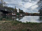
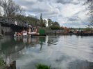
A couple of pictures at 15:27 today (23 April) taken from a position of safety on the opposite bank:
 

Attachments

  • 20230423_152727.jpg
    20230423_152727.jpg
    4 MB · Views: 503
  • 20230423_152749.jpg
    20230423_152749.jpg
    3.1 MB · Views: 493

LYRobert

Member
Joined
18 Apr 2022
Messages
81
Location
Banbury
The Thames loops round in a big U-bend to the west, so there's another bridge approx. 2 miles south over the same river. It looks to be a similar sort of bridge. Is that one in good order, I wonder?
 

webweasel

Member
Joined
4 Apr 2023
Messages
23
Location
Oxford
The Thames loops round in a big U-bend to the west, so there's another bridge approx. 2 miles south over the same river. It looks to be a similar sort of bridge. Is that one in good order, I wonder?
Who can say. Appleford a single span, but what is slightly concerning is there are gravel pits locally to that bridge too so geological conditions may be similar.
 

JKF

Member
Joined
29 May 2019
Messages
700
The Thames loops round in a big U-bend to the west, so there's another bridge approx. 2 miles south over the same river. It looks to be a similar sort of bridge. Is that one in good order, I wonder?
If they’d have built the line through Abingdon in the first place they could have done away with both river crossings.
 

Benjwri

Established Member
Joined
16 Jan 2022
Messages
1,871
Location
Bath
The river and railway structure aren't perpendicular making structures more vulnerable to turbulence and scour.
The central support is parallel to the flow of the stream though, this is what matters, not the angle of the bridge itself. Not to mention the issue is with the pier not the support.

Who can say. Appleford a single span, but what is slightly concerning is there are gravel pits locally to that bridge too so geological conditions may be similar.
Appleford is newer I believe, but there’s a support in either side followed by a brick arch, then the embankment, which leaves it further from the river and therefore more protected. It certainly isn’t of anywhere near as much concern as Nuneham has been even before this deterioration.
 

Benjwri

Established Member
Joined
16 Jan 2022
Messages
1,871
Location
Bath
If they’d have built the line through Abingdon in the first place they could have done away with both river crossings.
That was the original plan, but was scuppered by strong opposition from landowners at the time
 

Mathew S

Established Member
Joined
7 Aug 2017
Messages
2,167
If they’d have built the line through Abingdon in the first place they could have done away with both river crossings.
I mean, they'd still have had to cross the river at some point.
That was the original plan, but was scuppered by strong opposition from landowners at the time
Some things never change :D
 

Horizon22

Established Member
Associate Staff
Jobs & Careers
Joined
8 Sep 2019
Messages
7,584
Location
London
I mean, they'd still have had to cross the river at some point.

Some things never change :D

Haha true. But lots of slightly odd railheads around the country for a town that still over a century later hasn’t grown to encompass the station.

In related news, it seems XC only 1tp2h Oxford-Banbury is causing issues at the station for people coming from further north.
 

zwk500

Veteran Member
Joined
20 Jan 2020
Messages
13,420
Location
Bristol
Haha true. But lots of slightly odd railheads around the country for a town that still over a century later hasn’t grown to encompass the station.

In related news, it seems XC only 1tp2h Oxford-Banbury is causing issues at the station for people coming from further north.
If you look at old maps it's pretty clear Abingdon was built up hard against the river and even before the railway was a sizeable town for the time, so there was no obvious place to put a station that would be easy enough to build without prejudicing the mainline traffic between Birmingham and the GWR. Also I suspect the reason why Abingdon has grown in the shape that it has is because ground conditions by the river aren't great for houses, so a railway would be even less suitable!
 

Horizon22

Established Member
Associate Staff
Jobs & Careers
Joined
8 Sep 2019
Messages
7,584
Location
London
If you look at old maps it's pretty clear Abingdon was built up hard against the river and even before the railway was a sizeable town for the time, so there was no obvious place to put a station that would be easy enough to build without prejudicing the mainline traffic between Birmingham and the GWR. Also I suspect the reason why Abingdon has grown in the shape that it has is because ground conditions by the river aren't great for houses, so a railway would be even less suitable!

We’re getting off topic here but a station to the West of the main town would always have been the option and no doubt the town would have expanded that way.
 

Dan G

Member
Joined
12 May 2021
Messages
525
Location
Exeter
The track has already been taken away
I misunderstood the videos. I assumed the temporary piles and bridge support would allow reopening the line reopening on 10 June and then the embankment would be replaced. They're actually doing the whole job in one go, before the the 10th.
 
Last edited:

themiller

Member
Joined
4 Dec 2011
Messages
1,062
Location
Cumbria, UK
Is the plan to install piles either side of the bridge then install supporting beams under the bridge but supported by the piles before excavating the affected support and replacing with new?
 

swt_passenger

Veteran Member
Joined
7 Apr 2010
Messages
31,445
Is the plan to install piles either side of the bridge then install supporting beams under the bridge but supported by the piles before excavating the affected support and replacing with new?
Well that’s almost exactly how the two NR videos linked earlier in the thread explained it. I can’t think of any other way of doing it if it’s intended to leave the bridge spans in place?
 

InOban

Established Member
Joined
12 Mar 2017
Messages
4,221
I was assuming that they would put jacks (hydraulic or screw) on top of the piles, beams across, Jack up the bridge until was at or above its proper height, build the new abutment, lower the bridge on to it. Simples, but I'm not an engineer!
 

hwl

Established Member
Joined
5 Feb 2012
Messages
7,401
I was assuming that they would put jacks (hydraulic or screw) on top of the piles, beams across, Jack up the bridge until was at or above its proper height, build the new abutment, lower the bridge on to it. Simples, but I'm not an engineer!
That is exactly what I'm assuming they will do (and I'm an engineer...)
Hydraulic jack to higher than needed then insert packing blocks for few weeks then jack to remove packing blocks and lower onto new abutment when complete.
 

800301

Member
Joined
29 Dec 2022
Messages
197
Location
Essex
On page 7 of 'RAIL' (issue 981 - April 19 - May 2 2023). Part of the sentence is rather interesting...

GWR said it hoped to offer a restricted service to Marylebone using Class 800 IET trains "in the coming weeks" . It said passengers from Hereford and Worcester should travel via Birmingham or Bristol.
It was also looking at some services using the Greenford line in West London to Paddington from the Chiltern route. It considering lending Chiltern Railways additional rolling stock, but found safety systems were not compatible.

While 5 car IET’s are cleared into Marylebone I can’t see it happing with how congested the line is at the moment.

I think it’s the Turbo’s that aren’t compatible with each other not that GWR have any spare ones sitting about
 

GrimJosef

Member
Joined
24 Apr 2023
Messages
6
Location
Didcot
I mean, they'd still have had to cross the river at some point.
Not necessarily. The river loops. If the line had gone west of the loop it would never have had to cross the Thames near Abingdon at all (although it would have had to cross the Ock, though that's usually tiny). As it is it crosses the Thames twice.

If you look at old maps it's pretty clear Abingdon was built up hard against the river and even before the railway was a sizeable town for the time, so there was no obvious place to put a station that would be easy enough to build without prejudicing the mainline traffic between Birmingham and the GWR.

The relationship between town and river has been complex since before the Norman conquest. The town had a very large Saxon abbey whose monks arranged for the river's course to be altered more than once, both to improve navigation and to power their mill.

On a point of detail, Abingdon did have a railway station between 1856 and 1963 (for passengers) and 1984 (for goods). It was a few hundred metres from the river, and close to the town centre. It was the terminus of a branch line though.

I confess I've joined the forum largely to keep in touch with this very informative thread. I hope that's OK. I try to get out for a 20 mile walk once a week and one of my routes follows a footpath which runs alongside the railway south of the Nuneham viaduct and then, at the river, turns west and heads to Abingdon. By way of thanks for your useful info I will see, if the weather's kind and the path's still open, if I can get there towards the end of this week and post a few pictures of the works as seen from their side of the river. I should say though that the ground immediately south of the river and west of the railway embankment is most of the time completely waterlogged (up to a foot of standing surface water in places). I can negotiate that, but if it turns out to be any deeper now then my access will be pretty limited.
 

Nottingham59

Established Member
Joined
10 Dec 2019
Messages
1,656
Location
Nottingham
I will see, if the weather's kind and the path's still open, if I can get there towards the end of this week and post a few pictures of the works as seen from their side of the river.
That would be very much appreciated. And welcome to the forum!
 

Nicholas43

Member
Joined
16 Jun 2011
Messages
514
...one of my routes follows a footpath which runs alongside the railway south of the Nuneham viaduct and then, at the river, turns west and heads to Abingdon.
The path beside the railway from Thame Lane Bridge to the river has Closed signs on it, and has in practice been taken over as an access road to the site, with an impassable gate at the compound about half way along. The path on the left bank (i.e. the Culham side) of the river from Abingdon to the bridge was passable, wearing Wellington boots, when I last tried it. But it was very soggy beneath the Motocross place, and you don't get much view of the works. You get the best view from the right (i.e. Radley) bank, looking across under the bridge.
 

GrimJosef

Member
Joined
24 Apr 2023
Messages
6
Location
Didcot
Thanks for that. I'm not surprised there are Closed signs and I wouldn't have crossed any barrier between the neighbouring land and the works themselves.

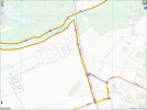
In practice the path that walkers actually follow isn't usually the official right of way (see attached county council access map). The latter hugs the embankment very tightly and there are the remains of a worn out chainlink fence between it and the motocross area. However it's narrow and steep and muddy in places and, since hardly anyone seems to use it, pretty overgrown. Instead folks heading from the Culham site towards the river use the motocross operation's track, just to the west, then drop down to the water meadow and cut the corner across that, as their footwear and the standing water permit. The motocross people are quite often there, flattening their track out. They seem not to mind.

Your pictures of the river and abutment works are lovely and clear and I couldn't hope to better them. I was hoping I might be able to see, from sideways on and possibly from a raised viewpoint on the motocross area, what was happening with the embankment itself.

OCC access map Nuneham viaduct.png
 

The Planner

Veteran Member
Joined
15 Apr 2008
Messages
15,982
While 5 car IET’s are cleared into Marylebone I can’t see it happing with how congested the line is at the moment.

I think it’s the Turbo’s that aren’t compatible with each other not that GWR have any spare ones sitting about
Are they actually cleared? I have yet to see anything that says they are.
 

JN114

Established Member
Joined
28 Jun 2005
Messages
3,355
Are they actually cleared? I have yet to see anything that says they are.

They’re in the NR Statement of Compatibility as authorised. It was looked into and confirmed very early on; possibly even day one. Not sure why that hasn’t ever filtered into Sectional Appendix for LNW South.
 

CyrusWuff

Established Member
Joined
20 May 2013
Messages
4,033
Location
London
Are they actually cleared? I have yet to see anything that says they are.
A quick look at the LNW(S) and Western Sectional Appendices shows no route clearance information for Class 8xx in either, even though you'd expect it to definitely appear in the Western one.
 

The Planner

Veteran Member
Joined
15 Apr 2008
Messages
15,982
They’re in the NR Statement of Compatibility as authorised. It was looked into and confirmed very early on; possibly even day one. Not sure why that hasn’t ever filtered into Sectional Appendix for LNW South.
Marylebone was never included in the vehicle change consultation though.
 
Status
Not open for further replies.

Top