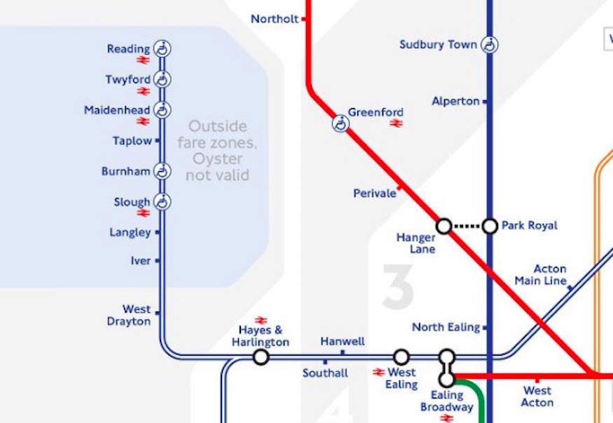
The London Tube and Rail Map shows all the tube and rail connections, including Thameslink. But it is quite a large and complex map, and I can understand why they want to produce something simpler for the inner area. Unfortunately the Tube Map is become a bit of a bad compromise, showing the Overground, trams and now TfL rail services right out to Reading and Shenfield, as well as the tube, but not Thameslink or Moorgate services, for example. It would be better if they limited the tube map to the area covered by the tube, including relevant rail services within that area (Overground, TfL Rail, Thameslink, etc) with arrows to places like Reading and Shenfield outside that "tube area". After all, you can look at the Tube and Rail Map if you want detail of services outside that "tube area".
Yes - something like the existing London Tube and Rail map is what I meant by my (B) above. Except perhaps it shouldn't confuse people by duplicating lines if there's more than one company running on that section. And it probably ought not to include any lines which don't stop anywhere [except for the terminus] in Greater London - these appear on the south-east region map and that's sufficient.
In terms of a slimmed-down tube map [my (A) above] - which, as you say, is currently a bad compromise - I'd limit the extras (ie beyond the underground lines) as much as possible. So DLR and perhaps trams, yes. Trunk (within-Greater-London) sections of Thameslink and Crossrail [when the latter finally
is running through the centre], yes, because they're a kind of RER-equivalent (going though the city; high-frequency; and can usefully be used in the way you use the tubes). Beyond that, as little as possible, since it decreases rather than increases usefulness. I admit there are difficult judgements to be made - where I'd draw the line [sic] is including only frequent services which
might, had history been different, have been "underground" lines, which have underground-style service levels, which are primarily inside-London services, and which integrate well with the underground. So
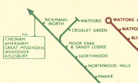
maybe the Moorgate line, perhaps the original "outer circle" Overground.
But if extra
is to be added to the tube map, the services should be either extensions/branches of underground lines [eg if the Bakerloo gets to Catford Bridge and Hayes, then that branch line obviously becomes part of the underground); or the relevant routes should be
branded as part of the Underground, given an underground name and colour, and conceptually integrated. So, eg, the first sections of what is confusingly called the
Overground [confusing because it messes with Londoners' parlance of "the
overground" - meaning any "proper trains", as distinct from "the underground"] might become the Outer Circle line or the Ring line [or whatever]. It would be better and easier to add one or two new "underground lines" to the tube map like this, in cases where existing railways "make sense" as part of the system in terms of the purposes they serve, rather than a creeping rebranding of rail lines as "the Overground", just because TfL has control, and adding them one after another to the basic tube map.
In this connection, the idea of calling the future Crossrail service the Elizabeth Line, as though it were a tube line, is another manifestation of TfL's absurd way of doing things based on who runs them rather than on the purpose they serve. Crossrail
obviously makes no more sense being branded as though it were part of the underground than Thameslink does - they both benefit from a more generic name like Thameslink and Crossrail. As long-distance inter-regional railways, running well outside London - that also, usefully, run through the middle of London - treat their Greater London sections as RER-style services and put them on the tube map, but don't pretend they
are underground lines.