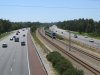
I guess you are talking about a sort of co-operative new build road/rail route on the surface?
That is the most probable scenario.
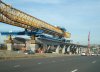
However it is entirely possible to build an elevated deck over an existing road without closing it. Seen it wiv me own eyes guv. Monopiles/piers are installed and then the bridge deck is jacked out and extended to span them. Apparently the term is "span launching".
Obviously a lane or two has to be temporarily closed while the piles are being sunk along the median... but if one lane of the M4 can be permanently closed for a bus lane...
I understand that some piling techniques are relatively quiet, and fast, and could probably be done at night if not in a residential street, enabling the road to be fully reopened during the day if required (depending on where you park the machines).
--- old post above --- --- new post below ---
When the Kyle of Lochalsh line was disrupted by a landslide, this also affected the A890 (I think that's the number) so as a temporary solution, the road was rerouted on to the railway using material so as not to destroy the railway for a distance.
Ah, I see from this news link that the line did indeed remain open to rail. Splendid!
http://www.obantimes.co.uk/2012/03/19/stromeferry-road-traffic-diverted-on-to-railway/#more-3398