• Our booking engine at tickets.railforums.co.uk (powered by TrainSplit) helps support the running of the forum with every ticket purchase! Find out more and ask any questions/give us feedback in this thread!

Stanton New Gate Sidings in Stapleford - any info?

Status
Not open for further replies.

M7R

Member
Joined
15 Sep 2010
Messages
263
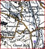
I have been looking back through old OS maps on old-maps.co.uk as I have been across a foot brige a number of times while out on my bike and always noticed how it was very long... so I guessed it must have previously gone across about 10 lines rather than the 2 it goes over now.. when looking on google earth theres clearly what look like old sidings so I had a good look on the old OS maps.. and low and behold it was a HUGE siding from 1914 time to the late 70s early 80s (the 1984 maps shows that most of the sidings have gone by then sadly!)

so what was Stanton New Gate Sidings used for? any one know? was it just general stock or something in perticular?

the tress is the area that was sidings
http://maps.google.co.uk/maps?hl=en...34336,-1.276817&spn=0.00745,0.022638&t=h&z=16

and you can also see the foot brige that I cross thats huge,

the old OS maps can be found here http://www.old-maps.co.uk/maps.html?txtXCoord=448600&txtYCoord=337643

any info would be great

Cheers

Karl
 
Sponsor Post - registered members do not see these adverts; click here to register, or click here to log in
R

RailUK Forums

Wyvern

Established Member
Joined
27 Oct 2009
Messages
1,573
I thought at first that it might be to do with the present recently departed Stanton Ironworks but it's too far south. I'm thinking your footbridge is the one marked with a blue square on my map on the western edge of Stapleford.

There was another large ironworks to the north of Stanton by Dale, which I think was Stanton Old Works. The station shown was Stanton Gate, which may have got its name from there being level crossing gates there when the line was first built. There was also a brickyard in the vicinity.

The area you refer to I think was Stanton Gate Sidings (both up and down) though the down sidings were a little further north. (I cant find any reference to a Stanton New Gate sidings)Was there a signal box nearby?

I'm guessing that the sidings would handle goods coming off two branches. One was to Stanton Old Works and connected to the Dale Colliery Tramway. The other branch was to Mapperley Colliery, Shipley Colliery and West Hallam Colliery and Stanton New Works.
 

Attachments

  • Capture.jpg
    Capture.jpg
    233.6 KB · Views: 19
Last edited:

sprinterguy

Established Member
Joined
4 Mar 2010
Messages
11,065
Location
Macclesfield
^^^^Wyvern beat me to it^^^^

It was most likely exchange/staging sidings for Stanton Ironworks, which lay immediately to the north west of the sidings on the oppositie side of the running lines. It had a healthy flow of coal and iron ore transported in by rail via Toton yard until the late 70s/early 80s.
 

M7R

Member
Joined
15 Sep 2010
Messages
263
Since posting that I found the iron works but wasnt 100% sure if that was the siding for it or not. infomation on the sidings seems very thin on the ground (unless im looking in the wrong place) which seems a bit odd as by the look of the maps it was a big works!
 

Wyvern

Established Member
Joined
27 Oct 2009
Messages
1,573
Ok Here is the Midland Railway plan from the early twentieth century

The Old Works Branch is the one to Stanton Old Works. The other is to Mapperley Colliery and Stanton New Works.
 

Attachments

  • midland map.jpg
    305.6 KB · Views: 135
Last edited:

M7R

Member
Joined
15 Sep 2010
Messages
263
Brill, thanks for the info! do you have a bigger overall view of the area? it would be nice to try and marry up the map with an aerial photo etc and work out what way where, but your help is much appreciated! it appears that there was alot more interesteing industy and rail in the area than I reliased,

like the old viaduct thats further north.. its now a grade 2 listed building and I have often wondered about while passing it on the train.. I found out today there used to be big banks on either side leading too it but these were demolished... but the big viaduct oddly left standing in the middle of no where!
 

bangor-toad

Member
Joined
20 Feb 2009
Messages
599
Brill, thanks for the info! do you have a bigger overall view of the area? it would be nice to try and marry up the map with an aerial photo etc and work out what way where, but your help is much appreciated! it appears that there was alot more interesteing industy and rail in the area than I reliased,

like the old viaduct thats further north.. its now a grade 2 listed building and I have often wondered about while passing it on the train.. I found out today there used to be big banks on either side leading too it but these were demolished... but the big viaduct oddly left standing in the middle of no where!

Hi there,
Have a look on Multimap at the area around Ilkeston. There's a huge number of old railway routes still evident. If you can track them, then I challenge you to trace out the route of the Nottingham Orbital railway! :D
(That's not the actual name of it but there was track there once...)

There's an interesting oddity with Multimap on the viaduct you mention. If you look at the "Aerial View" then it shows the old colliery and the associated buildings and conveyers. If you switch to "Birds Eye" then it's a more recent set of images with all of the buildings demolished.

Enjoy!
Jason
 

Wyvern

Established Member
Joined
27 Oct 2009
Messages
1,573
like the old viaduct thats further north.. its now a grade 2 listed building and I have often wondered about while passing it on the train.. I found out today there used to be big banks on either side leading too it but these were demolished... but the big viaduct oddly left standing in the middle of no where!

I'm guessing that's the Bennerley Viaduct that carried the Great Northern Line from Colwick Junction through Derby Frairgate to Egginton Junction.

I believe it was built as trestle structure because a conventional masonry viaduct would not have withstood the mining subsidence.

The OS maps I have are from Memory Maps. The railway diagrams are the Midland Railway System Maps now out of print but published by Peter Kay, Orchard House, Orchard Gardens, Teignmouth.
 
Last edited:

westhouses18b

Member
Joined
7 Jul 2010
Messages
10
Hi,

regarding the box, I can say however that in the sectional appendix for 1972 it's listed as worked Electric Token from Stanton Gate Shunting Frame to Stanton Gate New Works Sidings where the line split for West Hallam branch (2 mile 732Yds long) and as a through siding to Quarry HillRoad (1375 yards long) What's even more interesting, on the Signalling Records Society website they list the following map that they have!

SRS201001163 BR(LM) NS/335/74/3 12/12/1974 SCHEME Stanton Gate SF to West Hallam Colliery Sidings. Abolition of Stanton New Works Sidings and Fork Jn SBs and provision of one train working. Track circuits coloured in.

Also I believe in the Great northern books one of them has pictures of the box and I believe it was an LMR type flat topped modern box, which seems odd, but that's what I think it was, I'll have to check. Stanton Gate was of course an LMR flat topped Type 15 box but that was opened with the introduction of Trent.

Hope that helps? PM me.
--- old post above --- --- new post below ---
Evening,

I wrote a massive reply and didn;t realise my login had timed out!

Anyways, in short, the flat topped box i wrote about was in fact on the GN called Quarry Road, I found a pic of the New Works box and it's certainly a MR box but can;t see all of it as it;s behind a train but it's a standard looking box, not too large and it controlled the connection to the New works and coke ovens etc on the line from Stanton Gate to Mapperley, what's most interesting is whether it continued to be manned up to the previous post i worte which pointed towards a date when the section was altered from token working between Stanton Gate and the New Works box, one would guess that seeing as it had a token machine it continued to be manned, similar to how Masfield Colliery sidings and Rufford Sidings hung despite it's Eastern region neighbours being no signaller instruments and over on the WEst Coast side as close as Buxton the Hindlow branch was also a no signaller token machine as was Topley Pike between great Rocks and Buxton? So who knows? :roll:
--- old post above --- --- new post below ---
Stanton Gate North to End of Mapperley Colliery Branch Sectional Appendix 1960
Junctions and other features Running Lines Stations, Signal Boxes and Junctions Distance from Signal Box above Loops and Refuge Sidings Notes
Maximum permissible speed 15 m.p.h.

1 ↕ Stanton Gate North -
2 ↕ Stanton New Works Sdgs. 1m 265yds
3 ↕ Mapperley Junction (Foreman's Office) Token Station 2m 731yds
- ↕ End of Mapperley Branch 2m 808yds
--- old post above --- --- new post below ---
The 1922 Sectional Appendix shows:

Mapperley Jc (foreman's office) to Stanton New Works Sidings - Tablet

Stanton New Works Sidings - Stanton Gate north - Tablet
 
Last edited:
Status
Not open for further replies.

Top