• Our new ticketing site is now live! Using either this or the original site (both powered by TrainSplit) helps support the running of the forum with every ticket purchase! Find out more and ask any questions/give us feedback in this thread!

The "And in other news..." thread

PsychoMouse

Member
Joined
27 Jan 2020
Messages
392
Location
Birmingham
But the King does own all the swans in the UK.

Yes, I was going to mention this, about how writing to the King isn’t the most absurd thing ever.
Urban myth.

The King owns all unmarked mute swans in open water in the UK, but the only exercises ownership on certain stretches and tributaries of the River Thames around Windsor.

A pond in Gloucestershire is fair game should anybody fancy a swan sandwich, especially if its a Whooper swan.

Ridiculous that somebody can claim ownership of wild animals anyway.
 
Sponsor Post - registered members do not see these adverts; click here to register, or click here to log in
R

RailUK Forums

edwin_m

Veteran Member
Joined
21 Apr 2013
Messages
26,697
Location
Nottingham
These swan groups will have to cool it or they'll end up fowl of the beaks.

Why can't swans have an online meeting? Because they're all mute.
 

AM9

Veteran Member
Joined
13 May 2014
Messages
15,245
Location
St Albans
Pedant alert:

Actually 'mute swans' aren't mute, - according to Google, they make "an explosive snorting or hissing when threatened or disturbed". So they are well suited to online meetings, - especially on social media. ;)
 

GusB

Established Member
Joined
9 Jul 2016
Messages
7,408
Location
Elginshire
Pedant alert:

Actually 'mute swans' aren't mute, - according to Google, they make "an explosive snorting or hissing when threatened or disturbed". So they are well suited to online meetings, - especially on social media. ;)
But do they have the authority? ;)
 

najaB

Veteran Member
Joined
28 Aug 2011
Messages
32,291
Location
Scotland
Man who stole 200,000 Cadbury Creme Eggs brought to justice:

A man who stole 200,000 Cadbury Creme Eggs, causing a police panic about Easter, has been convicted in court.

Joby Pool was surrounded by a mountain of the foil-wrapped chocolate when police caught up with him at the weekend.

Recognising he was foiled too, he surrendered to officers with his hands up, prosecutors said.

He is due to be sentenced in Crown Court next month.


Mcr Warrior

Veteran Member
Joined
8 Jan 2009
Messages
14,704
This particular thread has very rapidly taken an
eggs-straordinary turn for the worse! :rolleyes:
 

MotCO

Established Member
Joined
25 Aug 2014
Messages
5,141
Recognising he was foiled too, he surrendered to officers with his hands up, prosecutors said.

The joker got in before the forum posters.
 

Peter Mugridge

Veteran Member
Joined
8 Apr 2010
Messages
16,180
Location
Epsom
It looks like my old school has hired Sir Humphrey Appleby to write their recruitment adverts:

The text in their tweet ( pictured below with the main building of the school ) reads: "We are seeking a Grounds Maintenance Operative with a Horticultural or/and Arboricultural specialisation to join our team and support the upkeep of our beautiful grounds."

Translation: "We are looking for a gardener."

1676641666774.png
 

brad465

Established Member
Joined
11 Aug 2010
Messages
8,683
Location
Taunton or Kent
Bolton's new stadium name is creating amusement:


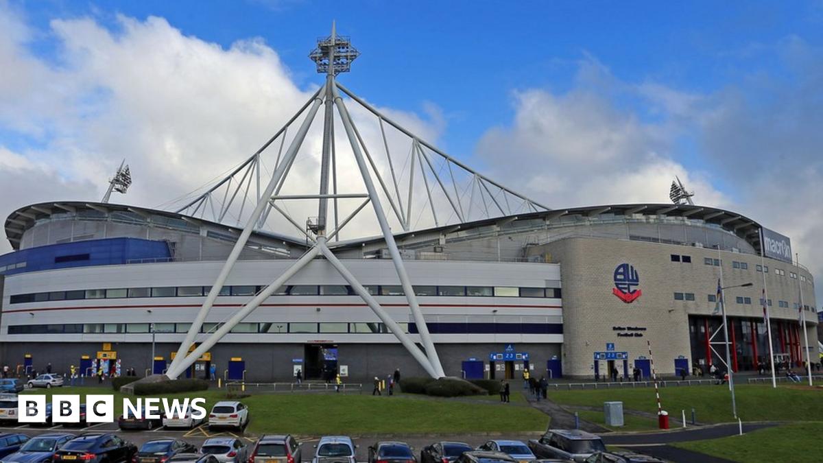
Bolton Wanderers stadium's new "tongue in cheek" name has been a hard one for fans to ignore, prompting chuckles and disbelief in equal measure.
The club have announced they are delighted to have agreed a deal with local building manufacturer Toughsheet.
It means the League One side will be playing at the Toughsheet Community Stadium for the next five years.
The company's boss said the announcement had been taken in the spirit of "schoolboy humour".
Managing director Doug Mercer told the Bolton News: "We're happy to have a bit of fun with it. Obviously the brand name is a bit tongue-in-cheek, a bit schoolboy humour.
"I can't wait to see them try and make each other say it on Sky Sports. It'll be a great laugh."

'Seriously?'​

Bolton said the partnership with the company, based in Westhoughton, represents the largest sponsorship deal in the club's history.
But news of the ground's latest moniker has been a hard one to take for some supporters, after less remarkable spells as the Reebok and most recently the University of Bolton Stadium.
One said: "Is this true? Seriously is this true?" with another joking: "Is it April 1st?"
Another tweeted: "Oh Bolton. Bolton. Bolton. What have you done? You've certainly got people talking. However, it'll always be the Reebok."
However, many simply took the opportunity to embrace the joke, with one fan adding: "If people don't like it, it's toughsheet."
 

Pete_uk

Established Member
Joined
28 Jan 2017
Messages
1,378
Location
Stroud, Glos
All kicking off in Plymouth.

'Man hit by car'
'The man is not happy'
 

Attachments

  • Screenshot_20221128_102308.jpg
    Screenshot_20221128_102308.jpg
    97.4 KB · Views: 42

A Challenge

Established Member
Joined
24 Sep 2016
Messages
2,835
Well let's face it....what could possibly go wrong !....everybody knows a Silva compass, and paper, for goodness sake ! OS maps are just so retro and passe...


While I have no problems personally with using my phone for a map, I wouldn't want to try walking away from roads anywhere just on Google maps - my normal map source doesn't really have terrain data properly so is not really suitable for very long hikes or planning routes, but works perfectly well most of the time with much better detail that Google (though I'm not going to say it replaces a back-up paper map if it's not somewhere I know)
 

Lost property

On Moderation
Joined
2 Jun 2016
Messages
734
While I have no problems personally with using my phone for a map, I wouldn't want to try walking away from roads anywhere just on Google maps - my normal map source doesn't really have terrain data properly so is not really suitable for very long hikes or planning routes, but works perfectly well most of the time with much better detail that Google (though I'm not going to say it replaces a back-up paper map if it's not somewhere I know)
Which is the whole point really. Google is fine for suburbia, but, it's not for the wilderness. True, there is Gov't kit available which does the job very well, but, Joe Bloggs isn't likely to have access to it. And besides which, a map and compass are basic essentials. What the report doesn't say, but alludes to, is, he doesn't appear to have been carrying another basic requirement... overnight survival kit and supplies either.
 

ABB125

Established Member
Joined
23 Jul 2016
Messages
4,018
Location
University of Birmingham
For me, an OS map or equivalent (whether in physical or electronic form) is essential for almost all outdoor exploration outside of suburbia. How anyone could think otherwise I'd beyond me (though I shouldn't really be surprised should I... :D)

Exceptions are my local area, where even if I don't know exactly where I am it doesn't take too long to follow a path until I get to somewhere I recognise, or short walks where due to the terrain you can pretty much always see the way you've come and where you're going.
 

Ediswan

Established Member
Joined
15 Nov 2012
Messages
3,267
Location
Stevenage
Which is the whole point really. Google is fine for suburbia, but, it's not for the wilderness. True, there is Gov't kit available which does the job very well, but, Joe Bloggs isn't likely to have access to it. And besides which, a map and compass are basic essentials.
For those who do prefer an electronic map, Ordnance Survey is available. That has the same information as a paper map. But of course, also carry the paper map plus compass, and know how to use them.

Edit: On the bright side, magentic variation in the UK is currently negligible. I can recall it being 12 degrees.
 
Last edited:

Peter Mugridge

Veteran Member
Joined
8 Apr 2010
Messages
16,180
Location
Epsom
Which is the whole point really. Google is fine for suburbia, but, it's not for the wilderness. True, there is Gov't kit available which does the job very well, but, Joe Bloggs isn't likely to have access to it. And besides which, a map and compass are basic essentials. What the report doesn't say, but alludes to, is, he doesn't appear to have been carrying another basic requirement... overnight survival kit and supplies either.
Even in built up areas the phone mapping cannot be completely relied on; I have had cases where the little red dot showing where the map thinks we are to be in a nearby place where we were not - and even moving along a different path from the one we were actually on.
 

D6130

Established Member
Joined
12 Jan 2021
Messages
7,268
Location
West Yorkshire/Tuscany
I use mapy.cz....an excellent on-line map resource from the Czech Republic which covers virtually the whole world in far more detail than Google Maps and shows many - but not all - footpaths in detail. If you enlarge the maps with your fingers, they will show contour lines and if you tap any two points with outstretched fingers they will show you the straight line distance in kilometres between those points. Not quite as detailed as the Ordnance Survey app of course but, unlike the latter, it's free.
 

Ediswan

Established Member
Joined
15 Nov 2012
Messages
3,267
Location
Stevenage
I use mapy.cz....an excellent on-line map resource from the Czech Republic which covers virtually the whole world in far more detail than Google Maps and shows many - but not all - footpaths in detail. If you enlarge the maps with your fingers, they will show contour lines and if you tap any two points with outstretched fingers they will show you the straight line distance in kilometres between those points. Not quite as detailed as the Ordnance Survey app of course but, unlike the latter, it's free.

That is using OpenStreetMap data. And probably SRTM for contours.

mapy_cz.png

https://www.usgs.gov/centers/eros/s...ation-shuttle-radar-topography-mission-srtm-1
The Shuttle Radar Topography Mission (SRTM) was flown aboard the space shuttle Endeavour February 11-22, 2000. The National Aeronautics and Space Administration (NASA) and the National Geospatial-Intelligence Agency (NGA) participated in an international project to acquire radar data which were used to create the first near-global set of land elevations.
 

Top