Notoriously muddy. It is possible to bypass that section by following the New River Path between Broxbourne station and Rye House. Or if you prefer pubs as landmarks, between The Crown and The Rye House.Thank you. The towpath was largely fine with only one short section, between Broxbourne and the Stort confluence, more muddy than not.
-
Our booking engine at tickets.railforums.co.uk (powered by TrainSplit) helps support the running of the forum with every ticket purchase! Find out more and ask any questions/give us feedback in this thread!
You are using an out of date browser. It may not display this or other websites correctly.
You should upgrade or use an alternative browser.
You should upgrade or use an alternative browser.
Walking and Rambling discussion
- Thread starter johnnychips
- Start date
Sponsor Post - registered members do not see these adverts; click here to register, or click here to log in
R
RailUK Forums
I had one of the wettest walks I've ever done yesterday, from Hollingworth Lake at Littleborough. I led 5 others for 9.5 miles in a figure of 8 from the lake through Peanock Farm and Bib Knowl to the edge of Milnrow, then over the M62 by the Tunshill farm access lane bridge, up to a path junction, down to Ogden reservoir, and down Bethany Lane to New Hey for lunch at the picnic tables outside the closed Bird in the Hand pub. Someone has felled a rotten ash tree on Bethany Lane, and we had to clamber over the sawn-up trunk, which had been left blocking the lane. From New Hey we walked uphill to the church and then the Station to Station walk (tracks called Carr Lane and Tunshil Lane), where the paths were like rocky streams. Then back to Hollingworth Lake by the Pennine Bridleway under the M62. But it was better than a November walk at Belmont near Bolton, where the temperature was below freezing all day and snow had fallen on top of ice, very treacherous underfoot.
Peter Mugridge
Veteran Member
...or do it in the summer like we did...Notoriously muddy. It is possible to bypass that section by following the New River Path between Broxbourne station and Rye House. Or if you prefer pubs as landmarks, between The Crown and The Rye House.
")
I walked this on New Year's Day. Towpath generally ok to walk in trainers without getting muddy.Has anybody done the Grand Union from Hayes towards Brentford, if so what's the path quality like? (Muddy towpaths are not fun, especially with the extra risk of making a splash if not careful)
Peter Mugridge
Veteran Member
Oh I missed that bit... Did it in the autumn; I'd agree with the above comment from Hadders that it's not a bad one to do at all. There's some photos in my trip reports thread.Has anybody done the Grand Union from Hayes towards Brentford, if so what's the path quality like? (Muddy towpaths are not fun, especially with the extra risk of making a splash if not careful)
You can expect some complicated routing at parts of it in the final stretches below Brentford Gauging Lock...
Agreed! To get right to the end where it meets the Thames you end up going round the houses a bit.You can expect some complicated routing at parts of it in the final stretches below Brentford Gauging Lock...
Kite159
Veteran Member
Thanks for the info on the Hayes - Brentford, might try and do that on my next London day weather permitting.
THC
Member
It is easier to follow by starting at Goat Wharf below Thames Locks.Oh I missed that bit... Did it in the autumn; I'd agree with the above comment from Hadders that it's not a bad one to do at all. There's some photos in my trip reports thread.
You can expect some complicated routing at parts of it in the final stretches below Brentford Gauging Lock...
THC
Acey
Member
- Joined
- 16 Nov 2018
- Messages
- 256
I really cannot believe the sense of entitlement that some people have ! out of boredom I have been reading reviews on Tripadvisor about their experiences of walking up Mt Snowdon ,some of the reviews are almost beyond belief ,here's just one "This was quite a steep hill and it could have been improved by concrete paths and maybe some toilets halfway up. I quite fancied a McDonald's but there wasn't one on this hill. I think it would go down a treat. Mobile reception is pretty poor so don't rely on it for Facebook, Snapchat, I really do think more effort could have been made by planting trees near the path as it was windy and ruined my hair. It's a big hill I need shelter. I would not recommend this hill at all until the Council improves it a lot. I would recommend the pancake shop and McDonald's in Caernarfon though. Much nicer" just one of many ,I first done Snowdon some 40 years ago and since then it seems to have gone way downhill ( no pun intended ) I realise that the paths need to be maintained due to the sheer footfall but it seems to have changed from the somewhat wild natural place it was to a sort of mountain theme park .Now it seems certain folk feel they are entitled to be supplied with the sort of facilities you will find in Alton Towers ,Some reviewer even mentioned the Ranger Path as terrifying ! seriously---- "We decided to do this climb part of a fundraising event ,we spent weeks researching the best route path to take being we were novice climbers ,we spent weeks walking up hills in prep for it ,we watched you tube videos of people doing the chosen path THE RANGER PATH ,and all i can say is DON'T DO IT it was the most terrifying experience of our life's ,the path is relentless starts straight away going up hill and never lets up ,the higher you go the worse the terrain becomes ,you clamber and i mean clamber over rocks ,steps,jagged rocks etc ,you cant walk more then 20 yards without stopping ,and in our case we started out really sunny and by the time we got a quarter the way up the weather changed ,it lashed it down it hailed and there was wind of around at a guess of 40 mph ,nearly blew us of our feet ,,be warned when i say don't attempt it, we seriously did not think we would get of alive ,we did manage to battle through and get to the top but it took 4.5 hours to get up there ,when your at the top there is at least another 20 mins walk up to the summit .and when u get there there are another 10 steps more up ...having pushed ourselves up there we were physically and mentally exhausted soaked through to the skin and beyond, and we headed into the cafe there ,omg what a shock ,because the weather blah blah blah " and so forth ,if you have never done the Ranger Path,believe me it's probably the quietest and easiest route,at no time is it scary ( try CribGoch for that ! ? rant over !
D6130
Established Member
You do have to wonder whether some of those reviews are tongue-in-cheek....although I think the last one sounded frighteningly genuine.
Acey
Member
- Joined
- 16 Nov 2018
- Messages
- 256
I'm sure you're right but there are so many that seem genuine complaints ,I remember reading one regarding Beachy Head ,said something like " boring ,not much to see or do just a load of grass ,the Council should really do something about it "
Fancy doing the Hadrians Wall path next. I'm doing Wallsend to Steel Rigg first - over three days starting Sunday. I'm coming home each day so it will be interesting to see how the public transport networks perform.
Will do the second half when I get another three days off.
A mobile OS app won't replace a papermap/GPS for serious walkers. On the vast majority of 'proper' hikes, you'll be facing low light and a highly useless pixelated screen as the reception gets lost in areas where and when you'll need it most.
Will do the second half when I get another three days off.
Yes but I don't think you can view them on a mobile device. Or at least I haven't managed to figure out how....I suspect not many people realise the OS maps are on Bing for free. For walking/cycling I much prefer the OS over Google et al, as rights of way are clearer and the contours and other markings give you a much better idea of the terrain.
A mobile OS app won't replace a papermap/GPS for serious walkers. On the vast majority of 'proper' hikes, you'll be facing low light and a highly useless pixelated screen as the reception gets lost in areas where and when you'll need it most.
Last edited:
Make that papermap/compass and we might agree. A wristwatch is also useful.A mobile OS app won't replace a papermap/GPS for serious walkers.
TBF, I've never owned a GPS (but have used them in the field) but given that they work on satellites rather than masts, I would argue they're still a hell of alot more reliable than phones. That still wouldn't resolve the battery issue though......
Make that papermap/compass and we might agree. A wristwatch is also useful.
Last edited:
ChrisC
Established Member
Yesterday I made the most of the sunny dry weather and went for a walk around Ashover in Derbyshire. It wasn’t a long walk, only around 5 miles, but there were some very steep and muddy climbs especially up to Cocking Tor from Milltown. Great views of Ashover village and from the hills above Overton Hall views right across towards Hardwick Hall and over into Nottinghamshire.
There are so many locations like Ashover which are well outside the Peak District National Park yet are just as beautiful without the crowds and parking charges. Last week I did a similar walk around Crich. You don’t have to venture many miles west of the former coal mining area towns like Alfreton, Ripley and Clay Cross before you are in countryside to rival places that are actually within the National Park.
There are so many locations like Ashover which are well outside the Peak District National Park yet are just as beautiful without the crowds and parking charges. Last week I did a similar walk around Crich. You don’t have to venture many miles west of the former coal mining area towns like Alfreton, Ripley and Clay Cross before you are in countryside to rival places that are actually within the National Park.
Does anyone have any experience of walking the rural bits of the Oxford Canal ?
The bits around Oxford and Banbury seem okay but a couple of years ago, I walked north from Aynho and found the canal had broken the bank and the towpath was impassable and I had to turn back. This has put me off trying various parts. I guess what I am asking is whether the towpath is generally in a good state of repair in your experience ... or if you have any recommendations of good stretches ...
The bits around Oxford and Banbury seem okay but a couple of years ago, I walked north from Aynho and found the canal had broken the bank and the towpath was impassable and I had to turn back. This has put me off trying various parts. I guess what I am asking is whether the towpath is generally in a good state of repair in your experience ... or if you have any recommendations of good stretches ...
Canal & River Trust
We're the charity looking after 2,000 miles of historic waterways across England and Wales. Find out how we're making life better by water.
Canal & River Trust
We're the charity looking after 2,000 miles of historic waterways across England and Wales. Find out how we're making life better by water.canalrivertrust.org.uk
I know of that site, it implies that there is nothing wrong with the section that I encountered problems at - just wondered if anyone had on-the-ground experience.
Yesterday I did a half-recce for a walk I have to lead in March; only half because the reduced service to Colne meant I couldn't get there in time to do a full day, without leaving home too early at 07:25. I left Colne station at 12:07 and walked alongside Colne Water on the south side of the town as far as a recreation area, where I turned right over a stone bridge and uphill to Winewall. I enjoyed the bridleway south of Winewall with good views of the valley towards Trawden. At the end of the bridleway I crossed a field and recreation ground diagonally, to reach Keighley Lane, a quiet lane with good open views, and walked down it nearly as far as Laneshaw Bridge, where I turned back along the Ferndean Way, which follows the Colne Water back to the recreation area where I had left it earlier. From the main road above the recreation area I took a bus into Colne town centre.
One of the thoughts that came to me while walking was what a direct Keighley-Colne line might have been like if anyone had been rash enough to build it. Technically, it would have been possible. Leaving the Aire Valley main line near where Airedale General Hospital is now, then running between Cross Hills and Sutton in Craven, it would have had to go up the valley of Holme Beck and then in a long tunnel under Cowling to emerge near Laneshaw Bridge. A route could have been found down the valleys of the river Laneshaw and Colne Water, south of and below the town, with a station nearer the town centre, joining the existing line near where the viaduct is now. Just as well it was never built, as the traffic potential of the former line via Earby to Skipton was greater (for the record I'm not a believer in reopening this line). All a pipedream of course, but one that occasionally occurs to me when walking a rail-less area (Longsleddale is another one). Similarly, I once met a retired Lt.-Col. of Marines who told me that he couldn't do a walk without thinking "where would I put a gun emplacement or a machine gunner, if I were defending this bit of country?"
One of the thoughts that came to me while walking was what a direct Keighley-Colne line might have been like if anyone had been rash enough to build it. Technically, it would have been possible. Leaving the Aire Valley main line near where Airedale General Hospital is now, then running between Cross Hills and Sutton in Craven, it would have had to go up the valley of Holme Beck and then in a long tunnel under Cowling to emerge near Laneshaw Bridge. A route could have been found down the valleys of the river Laneshaw and Colne Water, south of and below the town, with a station nearer the town centre, joining the existing line near where the viaduct is now. Just as well it was never built, as the traffic potential of the former line via Earby to Skipton was greater (for the record I'm not a believer in reopening this line). All a pipedream of course, but one that occasionally occurs to me when walking a rail-less area (Longsleddale is another one). Similarly, I once met a retired Lt.-Col. of Marines who told me that he couldn't do a walk without thinking "where would I put a gun emplacement or a machine gunner, if I were defending this bit of country?"
Kite159
Veteran Member
Yesterday I did something which had been on my list to do for a while. Walked from North Queensferry to Dalmenny station via the Forth Road bridge. Weather was decent (cloudy but with hardly any wind). Eastern carriageway was open giving good views of the rail bridge.
Dalmenny is on my areas to revisit for some old railway lines turned mixed use paths
Dalmenny is on my areas to revisit for some old railway lines turned mixed use paths
THC
Member
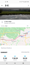
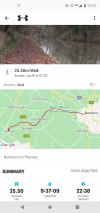
I walked 47 miles from Reading to Pewsey this weekend, staying in Newbury overnight, mostly along the Kennet and Avon towpath and with an almost constant flurry of Class 80x for company. Lovely.
THC
THC
Attachments
Peter Mugridge
Veteran Member
Now I've been considering the Kennet and Avon for ourselves for 2022, although not more than 10 miles in one day... how good is the canal access to and from the various intermediate railway stations? Newbury and Kintbury I'm familiar with - but not any of the others.
THC
Member
The railway runs alongside the K&A more or less all the way from Reading to Pewsey and again from Trowbridge to Bath.
THC
THC
Peter Mugridge
Veteran Member
Yes, but... are the station accesses all direct or do some of them divert round things on the way? If I've just done nine or ten miles and can see the station a short distance away, the last thing I'll want to do is have to go another half mile round something...The railway runs alongside the K&A more or less all the way from Reading to Pewsey and again from Trowbridge to Bath.
THC
I've travelled the Berk and Hants countless times, but the only bit of the canal I've walked so far is Newbury to Kintbury...
I've been meaning to ride along the towpath of the Kennet between Reading and Newbury for a number of years now.
I've only used it once before, as a shortcut between Thatcham station and Greenham Common park. This involved moving a hand operated swing bridge to cross the canal on the return leg.
I've only used it once before, as a shortcut between Thatcham station and Greenham Common park. This involved moving a hand operated swing bridge to cross the canal on the return leg.
THC
Member
As I said above, the railway runs largely alongside the canal between the places I have mentioned.Yes, but... are the station accesses all direct or do some of them divert round things on the way? If I've just done nine or ten miles and can see the station a short distance away, the last thing I'll want to do is have to go another half mile round something...
I've travelled the Berk and Hants countless times, but the only bit of the canal I've walked so far is Newbury to Kintbury...
Spelling it out in full, the stations at Aldermaston, Midgham, Thatcham, Kintbury, Hungerford, Bedwyn, Avoncliff and Bath are right beside the cut. Those at Theale, Newbury Racecourse, Newbury, Pewsey and Freshford require a c. 5 min walk to/from the towpath. Trowbridge is about a mile south of the cut. Reading is about a mile and a half from the confluence of the Kennet and Thames. I think that covers it but do let me know if I've missed anything.
THC
Last edited:
Did Kennet and Avon quite some years ago as far as the long chain of locks - about as far as you could sensibly do it using the trains, yes those were very convenient. Remember doing the Newbury bit on the day of Diana's funeral to escape the media (sad, I know) - there was something going on at Greenham Common then as well. Mean to do bits of it again one day, very pleasant and easy going.
Peter Mugridge
Veteran Member
I'm thinking, based on that, of splitting it into five portions...As I said above, the railway runs largely alongside the canal between the places I have mentioned.
Spelling it out in full, the stations at Aldermaston, Midgham, Thatcham, Kintbury, Hungerford, Bedwyn, Avoncliff and Bath are right beside the cut. Those at Theale, Newbury Racecourse, Newbury, Pewsey and Freshford require a c. 5 min walk to/from the towpath. Trowbridge is about a mile south of the cut. Reading is about a mile and a half from the confluence of the Kennet and Thames. I think that covers it but do let me know if I've missed anything.
THC
Pewsey to Bedwyn
Bedwyn to Kintbury
Kintbury to Thatcham
Thatcham to Theale
Theale to Reading
GPS is fine if you have a view of the sky. I have certainly had problems getting an accurate fix in woodland.TBF, I've never owned a GPS (but have used them in the field) but given that they work on satellites rather than masts, I would argue they're still a hell of alot more reliable than phones. That still wouldn't resolve the battery issue though......
THC
Member
All between 8 and 9 miles according to my trusty Nicholson's Guide.I'm thinking, based on that, of splitting it into five portions...
Pewsey to Bedwyn
Bedwyn to Kintbury
Kintbury to Thatcham
Thatcham to Theale
Theale to Reading
THC