Apologies for the info dump...
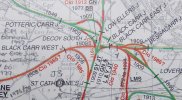
For anyone stumbling into this thread unprepared, without the necessary armfuls of maps and kendal mint cake, this Railway Clearing House junction diagram, from the Wikipedia page on the Dearne Valley Railway, might be helpful (you can zoom in to see it better):
https://upload.wikimedia.org/wikipe...l,_Shaftholme,_Stainforth_&_Thorne_RJD_23.jpg
The junctions under discussion are also labelled on this 1967 enlargement from an OS map:
https://www.flickr.com/photos/johnmightycat/32383654872
Incidentally, does anyone know when the end section of the ex DVR (from Black Carr West Junc over the ECML viaduct to Bessacar Junc) was lifted ?
According to C.T. Goode, this section of the line closed in May 1972 (although when the rails were physically lifted would be harder to determine). The date he gives for the (re)opening of the flyover is May 1977, which agrees with the info in previous posts:
The section of line from Yorkshire Main to Black Carr West remained open for the colliery traffic which ran round to St Catherines after the closure of the spurs to the main lines at Black Carr in May 1972.
...Rails were also put down again on the DVR viaduct over the GN main line as a flying junction, off the joint line from Lincoln. A line was also put down from St Catherine's to the down side of the GN at about the same time, in May 1977 and the whole area, some of it with bi-directional sections, was controlled from the Doncaster Power Box.
C.T. Goode - The Dearne Valley Railway (1986) ISBN 0950823996
https://www.abebooks.co.uk/servlet/SearchResults?sts=t&kn=0950823996
The "spurs to the main lines" would have been the flying connections from Black Carr East (signal box with 60 lever frame) to both Bessacarr Jn and Loversall Carr Jn. Originally there were 3 reception lines (plus the double track of the DVR line itself) between Black Carr West and Black Carr East.
Signalling diagram for Black Carr Sidings East is here:
https://www.lymmobservatory.net/railways/sbdiagrams/black_carr_sidings_east.jpg
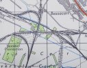
The reception lines can also be seen on this OS map, where all tracks have been highlighted:
https://www.flickr.com/photos/eckethump/51479786940/
Comparing that image side by side with google maps imagery, you can see that Black Carr East would have been close to "Black Carr Field" marked on google maps, where the current Flyover West Jn is located (i.e where the single line that diverges from the down side of the ECML at Loversall Carr Junction joins onto the Down Lincoln Flyover line). The current flyover connections from Loversall are probably using much the same earthworks / trackbeds as originally existed in DVR days before the closure of the line through Black Carr East in 1972. I think the current flyover lines from Flyover West Jn towards Doncaster, going underneath the South Yorkshire Joint railway, are adjacent to the old DVR line, using an adjacent span of the bridge which would originally have had those reception sidings underneath it. Approaching from the east, where the reception sidings started to fan out is probably where the current line diverges from the former DVR route towards the new Decoy South Jn (at the London end of Down Decoy sidings).
To make this clearer, a YouTube video exploring Potteric Carr shows the footpath under the South Yorkshire Joint Railway bridge at 11:25. I think the footpath is on the DVR trackbed here, with the current railway (from Flyover West Jn) adjacent to it, passing under the adjacent span of the bridge. Pausing again at 12:15 to look at the "You are here" marker on a map of the footpaths, the DVR trackbed would be on the blue footpath from this location to the South Yorkshire Joint line bridge. There's a photo in C.T. Goode's book on the Dearne Valley Railway which shows the DVR tracks going underneath the South Yorkshire Joint Railway at the same location, giving a similar perspective to the video footage.
The former route of the DVR is visible on google maps continuing due west through "Low Ellers Education Centre" and then turning south-west to meet the trackbed of the former curve from St Caths at the former Black Carr West Jn. The trackbed appears to be a foot or cycle path and can be traced under the A1 road towards Edlington, where an open area near "Yorkshire Main FC" is the old Yorkshire Main colliery site. On the S-R-S signalling diagram (1977-93) that Magdalia linked, the Yorkshire Main branch can be seen at the top, linked to St Catherine's Jn (usually referred to by local railway staff as "St Caths").
Also of interest is that in spite of the curve from St Catherine's Jn to Decoy South Jn being a new connection dating from 1977, the trackbed of the curve was already extant. In a diagram on page 32 of Oakwood's
The South Yorkshire Joint Railway and the Coalfield (B.J. Elliot 2002) there is a diagram showing this as a single track siding from St Caths, terminating close to Childer's Drain Signal Box on the Great Northern main line, presumably in the vicinity of the current Down Decoy sidings area, but without forming a connection. This old trackbed can be seen on the older OS maps as a disused line, before it was brought back into use in the 1977 changes and connected to the flyover lines at Decoy South Jn. The Wikipedia article on Potteric Carr (linked further down this post) mentions the area of Childers Wood being used for the tipping of colliery waste, which might explain the existence of the siding.
To make matters more intriguing, a different book by C.T. Goode (
Railways in South Yorkshire published by Dalesman in 1975, price £1.95) has a map showing a siding at Childers drain, but this time both the siding and the curve connect to the main line at Potteric Carr junction (opposite the current Potteric Carr junction which is on the Up side at the start of Low Ellers Curve). He describes the curve thus:
...on the west side of the SYJ a nebulous single line connection with the down sidings by the GN at Childer's Drain. Inspection of St. Catherine's Junction might lead one to suppose that points were never laid in for this connection, though the first twelve levers, being spare, were probably reserved for it. Childer's Drain cabin had an identical set of twelve spares. Possibly it was intended as part of a flying junction to the GN, of which the Low Ellers Curve was to be the other arm.
I assume the section immediately West of that was kept open for Yorkshire Main colliery until it closed in 1985/86 ?
In the same book just quoted (from 1975), after talking about the 1966 Dearne Valley closures, C.T. Goode says:
From Yorkshire Main the line has been left as an outlet to St Catherine's Junction, mineral trains being propelled thence and reversing to run forward over the SYJ. The Black Carr flying junctions have been taken up, the bridges remaining for use in a future modernisation scheme. Both Black Carr East and West boxes and the sidings are no more...
The entry for "St Catherine's" on this website gives 1985 as the closure of the link to Black Carr West (and therefore the Yorkshire Main branch as a whole).
https://www.sinfin.net/railways/stations/church.html
The Oakwood book mentioned earlier gives the closure date as October 21st 1985:
These closures included Cadeby... and the other main user of the DVR which was closed on 21st October 1985 between St Catherine's Jn and Yorkshire Main and eventually dismantled.
This is ten days after the closure date of the mine itself (as recorded by the Northern Mine Research Society) on 11th October 1985. However... this signal box website gives a closure date of 26/09/86 and says "the whole of the line was lifted in 1986 after the complete closure of the colliery."
https://www.signalboxes.com/yorkshire-main-signalbox.php
It's possible that the branch may have survived slightly longer than the pit to remove surface stocks, or that the mine closed on 11/10/85, the last train ran on 21/10/85 and official closure was on 26/09/86, but it's not entirely clear (may depend on how different sources define closure - as the last time it was used by a train, or the offical date it was taken out of use). The Cobb atlas isn't very helpful here, suggesting that the Yorkshire Main end of the branch closed a year after its connection to the rest of the network at St Caths!
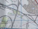
I was looking at my OS 1979 map and noticed how much of Bessacer junc was lifted by then.
Good point; even if the map is slightly out of date it shows the 1972-1977 situation. If the original connections from Black Carr East to the Lincoln line were removed in 1972, and the flyover later re-used in the 1977 re-signalling, there wouldn't really have been a functioning junction at Bessacarr during these years, as the Lincoln line would have connected to the Doncaster area solely using the flat junction at Black Carr. The old layout at Black Carr junction is seen clearly if you zoom in on this lovely shot from February 1977 (pre-resignalling) with semaphores, a deltic, the signalbox and junction in the background, behind which is the flyover structure which would have been disused at this date:
https://www.flickr.com/photos/126693116@N06/27077039059/
A hand-drawn diagram of the junction can be seen on this page (click to view slightly larger):
https://www.gersociety.org.uk/index...ling-diagrams-from-some-gn-ge-joint-locations
Another Deltic picture, taken on the Lincoln line in September 1977 after remodelling /resignalling work had been done, shows the new single line connection from the Up East Slow at Black Carr junction, and what I assume are a couple of redundant sidings in the foreground, with Black Carr signal box and junction near the back of the train.
https://www.flickr.com/photos/126693116@N06/50140548412/
I would guess the photographer is standing with the flyover line behind?
This picture from 1969 shows an up class 31 at Bessacarr, with (I assume) Black Carr Jn box in the background.
https://www.flickr.com/photos/johnmightycat/5967105159/
I wonder if at this time in the 1960s, looking at the diagram on the GER page linked earlier, the connection over the flyover functioned more like a siding than a running line.
To compare the current layout, this is a nice drone shot of a Lincoln-bound train on the single track chord from the ECML, joining the flyover lines at Bessacarr Jn.
https://www.flickr.com/photos/geoff-griffiths/45090470374/
Zooming in reveals Flyover East Jn on the left, where a chord connects to the ECML at Loversall in the up direction. This requires up trains from the flyover lines to diverge onto the down flyover line at Flyover West Jn, running on the bi-directional down line over the flyover itself to Flyover East Jn and the connection onto the chord. The lattice girders of the flyover itself are also visible when zoomed in. The flyover lines have a pronounced left-right kink here, and from the foot crossing at Bessacarr, freights look impressive barrelling towards Doncaster at line speed (which I think is 50mph).
https://www.flickr.com/photos/66202473@N04/15198637122/
The original DVR layout at Bessacarr would have had the Up line (coming from the main flyover over the ECML) flying over the double tracks of the Lincoln lines from the ECML at Black Carr Jn, before joining the up line. The connection from the Up Slow of the ECML at Black Carr Jn was singled during the 1977 changes, as seen in the photo. Part of the structure of the former bridge taking the up line from the DVR across the Lincoln lines (after it has already crossed the ECML on the double-track flyover) is visible on google maps to the north of the Lincoln line, and you can just about make out the curving route it would have taken through the trees to the south of Hennings Road.
I find this (that is the opening of a specific piece of track on a new alignment by BR at a given point in time) particularly interesting, however I’m not entirely sure which piece of track this refers to, or where for example Decoy is located.
I have noticed in the past that a slightly complicated arrangement gives a segregated 4 tracks south of Doncaster and that some of this is electrified, giving quite a good up and down slow line that do not follow the alignment of the main ECML. If anyone could explain the purpose of these lines, how they relate to this curve and how they came to be electrified it would be greatly of interest.
Fear not! This is my local area, although I didn't grow up here, so investigating the railway history is of particular interest to me. I kept not quite finishing this post and coming back to it, making it longer and longer in the process, but hopefully this guide to the track layout between here and Doncaster station may be of interest to readers of this thread:
The Railway Clearing House junction diagram linked at the start of this post makes the historical angle easier to visualise. "Decoy" is marked as "Decoy Exchange Sidings" but can refer to sidings on both the up and down side (Up Decoy / Down Decoy yards).
As already mentioned upthread, I think the general idea of the 1977 resignalling in this area was to abolish the flat junction at Black Carr, and use the recently defunct Dearne Valley Railway alignments (including the flyover across the ECML still in place) to create a segregated Up and Down Slow on the down side of the ECML, diverging from the existing Lincoln line and continuing to Doncaster station. The new curve from St Catherine's junction to join these slow lines (at Decoy South Jn) would have allowed northbound MGR traffic from the Worksop area to the Knottingley area (e.g. Thoresby Colliery to Drax) to avoid conflicting moves across the ECML. Southbound freight traffic from the down side (e.g. Belmont Yard) towards Retford or Lincoln could use the flyover to avoid crossing the ECML on the flat. The resulting segregation of the fast lines mean that if a train leaves Doncaster station on the Up Fast, there are no routes diverging off it, or crossing it, within the Doncaster area. Arriving northbound into Doncaster on the Down Fast, there are connections on the down side to and from the slow lines, but other than that, no conflicting routes or junctions before reaching Doncaster station.
The Up and Down "Decoy" yards are situated close to where these slow lines become the up and down flyover lines as they diverge from the ECML. "Down Decoy" now consists of a handful of double-ended sidings next to the mail terminal, but at one time there were numerous dead-end sidings (with buffer stops at the south end) where the mail terminal was later built. This is a modern view looking south - none of the photos linked are mine:
https://www.flickr.com/photos/alanpadley/40495455921/
GBRF trains are stabled in the 4 sidings at Down Decoy Yard in front of the camera. To the left of the wagons is the ECML proper, with the turnout (not extensively used) from the Down Fast onto the reversible Down/Up Slow No.1 at Decoy North Jn. To the right are the electrified flyover lines which give access to Lincoln, plus the South Yorkshire Joint line (via the curve to St Caths from Decoy South Junction at the south end of the yard) and also give the option of rejoining the ECML, via the flyover and the chord from Flyover East Jn to Loversall. Note how the flyover lines turn quite sharply away from the ECML to the right (before veering back to cross over it).
A similar perspective, standing slightly to the left, shows the view over the fast lines:
https://www.flickr.com/photos/alanpadley/52772606443/
Zoom into the distance and a grey bridge is visible. This is the South Yorkshire Joint line crossing the ECML. Trains from St Caths (i.e. from the Worksop direction) have the option of taking St Catherine's curve to join the flyover lines at Decoy South Jn, passing to the right of the photographer, or they can cross the ECML on that bridge and either continue to Kirk Sandall on the freight-only line (and on towards Scunthorpe / Immingham / Hull) or turn left onto the bi-directional "Low Ellers Curve" which can be seen swinging in from the left.
The Up Slow here is bi-directional, and freight from the Lincoln line uses it to access Up Decoy Yard and the Freightliner Railport container terminal, via the connection seen to the left of the Azuma.
This photo from 1985 shows a similar view with less clutter:
https://www.flickr.com/photos/blue-diesels/10360265653/
The advantage of keeping the frequent MGR trains away from the ECML can be appreciated (there would be more sidings to the right). Low Ellers curve can be seen more clearly without the luxuriant vegetation that surrounds it today! It curves around the pond in the background (which is apparently a result of mining subsidence from a seam of Rossington colliery) and eventually turns back the other way to join the South Yorkshire Joint line from Kirk Sandall and cross the ECML on the aforementioned bridge to reach St Cath's. The layout at St Cath's functions as a run round loop when required, and given the lack of flat connections across the ECML, this is a now a useful way of moving infrastructure wagons from the Up side (Up Decoy Yard, Wood Yard) to the down side (Down Decoy, Belmont). For example the lunchtime 6N71 Up Decoy Yard - Tyne Yard departs south onto the Low Ellers Curve, crosses the ECML on the bridge, runs round at "St Caths" and reappears coming north on the flyover lines towards Doncaster station on the down side. It could depart Up Decoy northbound using the transfer line (see below) but that would put it into platform 1 or 3 at Doncaster, requiring an awkward conflicting move across to the Down Main. The Low Ellers curve is also used as long headshunt for shunt movements at Up Decoy yard.
Looking in the down direction from the same bridge (or pair of bridges, technically) 66094 is recessed on No.3 Up Goods at Up Decoy with a service from Plasmor at Heck:
https://www.flickr.com/photos/49068127@N06/51146133325/
On the far left are the slow lines from the flyover (Up/Down West Slow No.1 and Down Slow No.2 at this point), with a connection onto the Down Fast that sees only limited use. To the right of the fast lines there is the electrified Up Slow and then three Up Goods lines (with the 66 on the third). The line next to it (with a ground position signal visible at the north end) is the Transfer line, allowing northbound departures. A typical use of this line would be for light engines returning north after arriving into one of the adjacent sidings with an engineer's train. When the Lindsey - Ipswich depot fuel tanks were running, I saw it use the reversible Up Slow (from the chord off the Lincoln line to Black Carr Jn) and then run through Up Decoy on the Transfer Line, which would bring it out on the Up side of Doncaster station, to run through platform 1 or 3 to access the line to Scunthorpe and Immingham without crossing the ECML.
There are 4 Up sidings to the right of the Transfer Line (with some coalfish wagons on the second of these) which connect to the transfer line at the north end. As I understand it, only the 4th of these has a signal allowing northbound departures, reflecting the location's original primary role as an Up Yard. Engineer's trains heading north from Up Decoy can propel out of these sidings (to the headshunt or onto Low Ellers Curve) and then depart north using the transfer line - on Saturday nights for example, the conflicting moves at Doncaster are less of a problem.
The Up Slow here wasn't originally bi-directional, although the single-track chord from the Lincoln line onto the Up East Slow at Black Carr also functioned as a "Down loco" line giving access to Carr loco via the Transfer line in Up Decoy sidings. In a resignalling a few years ago, I think the Up East Slow was made fully bi-directional from Black Carr Jn to Doncaster station (Recent Trackmaps show it renamed as "Up Slow"). Lincoln line passenger trains could use it to access the platform 2 bay on the up side of Doncaster station, but they are normally timetabled to use the flyover lines and the reversible Down West Slow, to and from bay platform 5 on the down side.
Another photo gives a slightly different view of Up Decoy from the same bridge:
https://www.flickr.com/photos/alanpadley/32536503662/
The Class 70 is on the No.1 Up Goods Loop, while the 66 is coming from No.1 Up Siding. The Class 60 appears to have been relegated to local "pilot" duties, the T27 / T28 tripper, a role sometimes given to naughty engines, or those with worn wheelsets approaching the limit that requires a visit to the wheel lathe. The 60 is coming from a fan of 8 double-ended sidings behind the relatively new 2-road wagon maintenance shed. The 8th and furthest of these (marked as "Key Road" on Trackmaps) is used as a through siding to access the Wood Yard beyond, and it may have come from there. It is approaching Potteric Carr Junction where it could turn left onto the Low Ellers Curve, or use the headshunt that also forms the connection onto the Up Slow, as seen in the photo with the Azuma. Meanwhile a Freightliner 66 can be seen peeking from behind the fence with a container train at the exit from Doncaster Railport (Freightliner container terminal).
There is another container terminal (Doncaster Iport) at St Caths, accessed using the St Catherine's curve from Decoy South Jn. Trains to the Iport from Felixstowe or London gateway (and return) pass Decoy yards in the down direction heading to Hexthorpe (on the Sheffield line), before running round and coming back to access the curve from the up direction. This detour would be avoided if the long-gone curve from Black Carr East (approximate site of the present Flyover West Jn) to St Caths was still there!
The Up goods No.1 line is mainly used for recessing Freightliner trains, while the other Up Goods lines and Up Sidings at Up Decoy are mainly used for stabling arriving engineer's trains. The rest of the sidings at Up Decoy, and the Wood Yard, are also used for engineer's traffic. In the Wood Yard there are around a dozen sidings for stabling engineer's wagons, the (fairly new) concrete sleeper factory with its loading gantry, a ballast stockpile and spoil offloading area, and an area used for the loading of new track panels, using sleepers from the factory. The Wood Yard is between Freightliner's Railport on the east side, and the Hitachi Depot for the ECML Azuma fleet, which was built on the site of Carr Loco Diesel Depot. I'm not sure of the origin of the "Wood Yard" name, the only wood visible being the timbers (from Pontrilas Sawmills according to the labels) stacked up at the concrete sleeper factory, used for spacing layers of concrete sleepers when loading them onto wagons. You can see into the Wood Yard from a public road (Ten Pound Walk) which ends at the entrance to the Hitachi depot. It's not often you can spot wagon numbers on google streetview, but SPA wagon 460824 is clearly visible stored in the Westinghouse siding (it's since been moved to Booth's scrapyard at Rotherham to meet its fate). The spoil tip can be seen in the sidings behind, and you can follow the road on streetview past the concrete sleeper factory and around the corner, where the buffer stops of Wood yard sidings can be seen through the fence, with the yellow gantry crane of the sleeper factory over the two loading sidings.
On the subject of names, the land in the Potteric Carr area (with all the junctions discussed) is fairly marshy and popular with wildfowl and the term "carr" apparently means "wetlands that are dominated by shrubs rather than trees." The "Decoy" name is related to a method of catching ducks, as mentioned here on a wikipedia page giving an outline history (including railway development) of the area discussed in this thread:
https://en.wikipedia.org/wiki/Potteric_Carr
The different named areas of Potteric Carr, some of which gave their names to railway features (e.g. Low Ellers, Decoy Marsh) are shown on this Wildlife Trust map:
https://www.ywt.org.uk/sites/default/files/2018-06/Potteric Carr named areas.pdf
References to "Drain" (e.g. Childers Drain) refer to the many drainage ditches in the area.
Moving further towards Doncaster station and turning to look in the Up direction, this 1986 view shows a northbound MGR behind a 56 at the point where the slow lines merge to pass under Balby Bridge (Bridge Junction, not far from the station).
https://www.flickr.com/photos/locohunter/47120859174/
Belmont sidings are to the right (near the "British Ropes" factory, with an 08 shunter visible). The diesel depot (Carr loco) is to the left, with the 15mph speed restriction onto the Up Goods and Transfer line giving access to Up Decoy sidings, which is how 66094 arrived into Up Decoy in the previous shot. The fast lines sweep majestically through the chaos, serene and undisturbed by freight movements. Under the bridge itself (really two bridges with a large road junction above) there are four tracks (Down Loco / Up East Slow, Up Fast, Down Fast, Down/Up West Slow 1) but these fan out into the 7 running lines seen here (8 if you include the Down Engine line around the edge of Carr Loco, since redeveloped into the Hitachi Azuma Depot). Starting from that 15mph sign there is the Transfer Line (bi-directional), Up Goods, the grass bank which is now covered in trees, Up East Slow, Up Fast, Down Fast, Down/Up West Slow No.1 and Down West Slow No.2. There's also a Down reception loop for Belmont yard behind the signal gantry (the rusty line on extreme right is a headshunt leading off it). At the time of the photograph, the Up East Slow wasn't bi-directional here (although it was bi-directional under the bridge, once the transfer line joined on).
At the time of the photograph, Belmont was a Speedlink yard, while Up and Down Decoy were mainly concerned with MGR coal traffic. Currently Up Decoy is an infrastructure yard (forming a Network Rail "Local Distribution Centre" in conjunction with the Wood Yard), Down Decoy is mainly used for stabling GBRF wagon sets between duties, while Belmont tends to function as extra siding space for infrastructure traffic (also some multiple units have been stored here). Belmont is useful for engineer's possession trains or infrastructure trips departing in the Sheffield direction, and some of these services will operate to/from Belmont with the wagons being moved between Belmont and Up Decoy via St Caths by the pilot engine on the local trip (previously a duty for an 08 but now using main line traction). After the closure of Carr Loco to build the Hitachi Depot, DB locos now stable at the back of Belmont Yard, where fuelling, routine servicing and minor repairs are carried out.
On the other side of the road interchange at Balby, looking north towards Doncaster station in 1984, the line diverging to the left, and continuing out of shot, forms the south side of a triangular junction to the Sheffield line at Hexthorpe:
https://www.flickr.com/photos/geoffsimages/52701333143/
Doncaster station is the other side of St James Bridge in the background, and a 47 is standing on the reversible "West Slow 2" line. Behind the 47, the slow lines merge with the lines coming into Doncaster station from Sheffield, and continue as the "two way goods lines" beside the station, on the down side between platform 8 and the West Yard.
A freight train taking the route from Lincoln over the flyover lines all the way into Doncaster on the slows will experience changes of line designation as follows: Down Lincoln, Down Lincoln Flyover, Down Flyover, Down Slow No.2 (or reversible Down/Up Slow No.1), Down/Up West Slow No.1 (where the tracks merge under Balby Bridge), Down West Slow 2 or Down/Up West Slow 1 on the other side of Balby bridge, then finally Two Way Goods 2 or Two Way Goods 1 around the back of the station.
Having almost reached Doncaster station, after surveying the local terrain and perhaps catching some ducks in the Decoy, we can enjoy a YouTube cab ride southbound on the flyover lines past Down Decoy sidings, over the flyover itself, rejoining the ECML again at Loversall. There are a small number of daily ECML services planned this way to maintain diversionary route knowledge (this diversionary use for ECML trains when the fasts are under possession is probably the main reason for the electrification). A sociably timed southbound run is 1A45 Leeds - Kings Cross, booked to use platform 8 at Doncaster, departing 18:18 via the slow lines on the down side and crossing the flyover before re-joining the ECML. Not all trains booked to run this way actually do, certainly not every day, so before attempting a journey over this route it's probably worth checking Real Time Trains to see which services have a history of actual passing times through Decoy South and North Jn (also anything running late is likely to be routed on the fast lines instead).
Some timestamps for the video:
0:10 Decoy North Jn (track straight ahead is the connection from the Down Fast and also gives access to Down Decoy sidings).
0:40 The GBRF 66 is in the platform of the former Royal Mail terminal. Note the tell-tale piles of sand in reception 5 next to it, where the sand trains from Middleton Towers often recess in the afternoon. Sidings to the left are Down Decoy receptions 1-4 (which together with 5 form Down Decoy yard).
1:30 Tracks from the south end of Down Decoy yard and the mail terminal merge at Decoy South Junction (caption is incorrect; Potteric Carr Junction refers to the junction with Low Ellers Curve at Up Decoy). I have a 225 Studios DVD cab ride over this section which also labels the junctions wrongly...
1:38 Curve to St Catherine's junction (also part of Decoy South Jn), giving access to the South Yorkshire Joint line to Worksop. Trains can also run round at St Caths to access Up Decoy.
1:51 South Yorkshire Joint line (from St Caths) passes overhead. I think the Dearne Valley Railway was under the adjacent span of the bridge to the right.
2:06 Flyover West Jn. The "Down West / Up West Slow" merges from the right. It can be used by down trains joining from the ECML at Loversall, or in the up direction to access Rossington colliery.
2:23 The original Dearne Valley Railway flyover over the top of the ECML (which is 3 tracks at this point - Up Slow / Up Fast / Down Fast)
2:37 Flyover East Jn. Straight ahead, the flyover lines head for Bessacarr Jn, where they join the single-track chord from Black Carr Jn and become the Up/Down Lincoln lines. We take the Up Loversall chord
3:20 Rejoining the Up Slow of the ECML at Loversall Jn
3:45 On the right is Rossington Colliery Junction, giving access to a run round loop which has a trailing connection to the old colliery site. Until recently there was a daily train of waste spoil in MBA box wagons (appeared to be contaminated soil from old local landfill sites being cleared) from the Ecofret facility at Rossington to Roxby landfill site. See
https://plumbloco.smugmug.com/Trains/BLS-Rossington-Recycler-13th-April-2019/i-GFnvGbd
3:51 Loversall Carr Jn, where the ECML becomes double-track towards Retford. Beyond is the abyss!
The layout at Loversall Jn, looking south towards Retford, is seen in this shot of an A4 heading north on a charter:
https://www.flickr.com/photos/alanpadley/44388254140/
To the left, the Up Loversall chord from the flyover joins the Up Slow, while on the right the reversible Down West / Up West Slow gives northbound trains access to rise up and join the flyover lines (it was used southbound to access Rossington colliery, via the run round loop next to the main line). This is Loversall Junction, with the four tracks merging into two a little further on at Loversall Carr Junction.
For the previous thread on some obscure former lines in the same area around Potteric Carr:
https://www.railforums.co.uk/thread...arr-junct-to-rossington-coll-bessacar.226567/
This thread is also relevant, a general discussion on the current use and purpose of the various freight lines around Doncaster, where I wrote some fairly detailed posts about other parts of the local freight network around Doncaster:
https://www.railforums.co.uk/threads/east-west-doncaster-avoiding-lines-current-usage.210175/