MatthewRead
On Moderation
We can't have that the W4 residents will be up in arms!Wouldn't it be amusing to hear that, in return for taking over the Ealing Broadway branch, Piccadilly trains would no longer be planned to call at Turnham Green?")
We can't have that the W4 residents will be up in arms!Wouldn't it be amusing to hear that, in return for taking over the Ealing Broadway branch, Piccadilly trains would no longer be planned to call at Turnham Green?
I think the "if it happens at all" is the key bit.Do you not think that the Met line extension to Watford junction will have been completed by then?... If it happens at all....
This is all mega interesting.I thought Old Oak would be seen as close , operationall close, to Willesden Junction. Fir passenger interchange as pedestrians.
Thus the whole complex to Rival Clapham Junction?

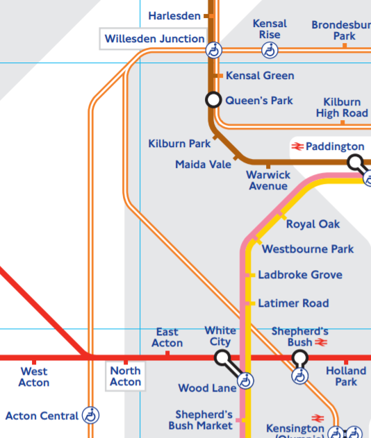
It's interesting in a big way because the distance between Willesden Junction and North/East Acton is one of the biggest distortions on the Tube map
Other examples of stations very close in real life but far apart on the Tube map are Queensway-Bayswater, Wimbledon-South-Wimbledon and Watford-Watford Junction (of course, the Croxley Rail link would fix the latter distortion).I never really noticed that before, are there many other similar 'distortions'?
Other examples of stations very close in real life but far apart on the Tube map are Queensway-Bayswater, Wimbledon-South-Wimbledon and Watford-Watford Junction (of course, the Croxley Rail link would fix the latter distortion).
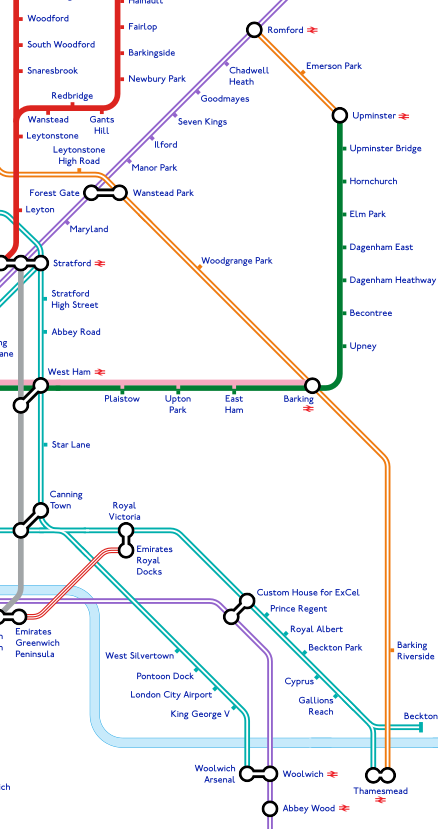
Barking's real-life proximity to the Thames was a problem when making the 2040 Tube map - since it makes Barking Riverside, which should actually be on the river, hard to place without drawing a stupidly long orange line.
I also had a smaller problem with King's Road Chelsea, because of how the Tube Map is distorted in that area: the Circle line is at 45 degrees between Victoria and Embankment and nearly vertical between Westminster and Embankment, but the Tube map shows it as horizontal.
Edit: Another distortion which the 2040 tube map does fix - Heathrow is nowhere near the Thames, but on the standard Tube map, Terminal 5 is on the riverside!
Another distortion is Clapham Junction to Victoria and to Waterloo, close by train but not by map!
With a connection south to Clapham Junction. North to Watford. West to ,well everywhere West , and one or two trains through Olympia turn left to Waterloo , using drain thereafter. East via Crossrail to West End , Farringdon , City (Liverpool St ) Canary Wharf etc... I see it out ranking Euston as a useful spreading out point.
How does this look, regarding extensions to Thamesmead?
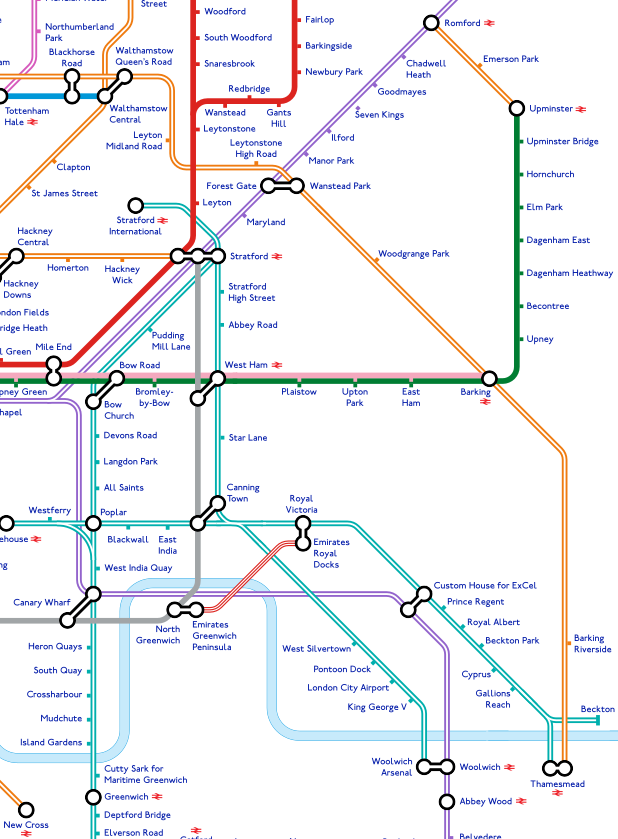
I've dared go no further than Thamesmead (no Abbey Wood or Woolwich) since they're not mentioned in the Transport Strategy. The District Line now has a 90 degree bend, but at least it running east to Barking properly reflects geography.
I guess it's a difficult thing to speculate on, but the Elizabeth-line-only map that TfL released did refer to an interchange between Woolwich Arsenal and Crossrail Woolwich:I'm not sure the tube map will show a connection between Woolwich Arsenal and the Crossrail Woolwich stations, as there's a reasonable distance between them (including a main road) and passengers from North Kent will be changing to Crossrail at Abbey Wood anyway

You've done a fine job with this map, but to me it shows that the whole nature of the Tube map needs to be rethought, as squeezing in services which go way outside London makes the map unreadable and the eastern section in particular horrendously misleading geographically. The Central section is becoming too crowded
After all on the current London Connections map (or whatever it's officially called now) the likes of Reading and Gravesend don't appear in the "London" side, but only in the South East side.
I also suspect that Thameslink will appear in some form on the Tube Map once the full service opens, it would be nonsense to not include a high frequency cross London service just because it doesn't come under TfL.
Might I ask what software that is?How does this look, regarding extensions to Thamesmead?
I've dared go no further than Thamesmead (no Abbey Wood or Woolwich) since they're not mentioned in the Transport Strategy. The District Line now has a 90 degree bend, but at least it running east to Barking properly reflects geography.
As for Thameslink, TfL has said it won't be on the Tube Map which I think is ridiculous, the Standard even reported the criticism for that. Having said that, I also think it will appear eventually, especially before the Northern City Branch closes 117 days due to the Bank station upgrade in 2020. The Northern line is far too crowded during the peaks at the moment, TfL is just inflicting misery because they don't run Thameslink, yet they are the ones who talk about integrating London's transport network.
I wonder what the chances of Thameslink coming fully/partly under TfL are? Can imagine the onboard service might not be all that great!
At the moment zero. TfL doesn't even include Thameslink as part of their aspirations map as the network goes too far out and splitting the suburban and interurban services into different operations isn't an option. I don't wish to make out like Paris has it all right, far from it, but there RER A and B are jointly operated by RATP and SNCF while RER C, D & E are solely SNCF operations. If the DfT and TfL agreed or the DfT forced it, a similar way could be applied here, seeing total integration without TfL actually operating the service.
How does this look, regarding extensions to Thamesmead?
The District Line now has a 90 degree bend, but at least it running east to Barking properly reflects geography.
I think that area needs the Thames straightening (bringing it northwards) and Elizabeth bringing southwards. Then the DLR can become more realistic, but it might involve east of Barking being made an inset to maintain proportuons...
As for Thameslink, TfL has said it won't be on the Tube Map which I think is ridiculous, the Standard even reported the criticism for that. Having said that, I also think it will appear eventually, especially before the Northern City Branch closes 117 days due to the Bank station upgrade in 2020. The Northern line is far too crowded during the peaks at the moment, TfL is just inflicting misery because they don't run Thameslink, yet they are the ones who talk about integrating London's transport network.
Once Thameslink is fully up and running, I'm sure public and especially Mayoral/London Assembly pressure will force TfL to include it. Including Cheshunt, Reading and Shenfield on the London Tube map, but not a major cross London service between St Pancras and London Bridge would make them look ridiculous...
Once Thameslink is fully up and running, I'm sure public and especially Mayoral/London Assembly pressure will force TfL to include it. Including Cheshunt, Reading and Shenfield on the London Tube map, but not a major cross London service between St Pancras and London Bridge would make them look ridiculous...
Maybe it's just me, but I often thought Thameslink made more sense as part of TfL rather than separate from it.
C'mon its a well-known fact TfL can't operate trains without longitudinal seating; it makes them too..."National Rail".
This wouldn't work.Simple solution: call them Northern City Line and Northern West End Line.
This wouldn't work.
No other line is named very similar, so no confusion.
Why is it ridiculous?As for Thameslink, TfL has said it won't be on the Tube Map which I think is ridiculous