Is it better to build a station that might get regularly flooded (and we have nothing other than a facebook post suggesting it will get flooded every other year) but works for 50 weeks of the year and can be funded, or to generate a design for a station that will never get flooded because it will never get funded as the costs of putting it on stilts blow any chance of getting the financial approval of the funding parties.then it seems rather more sensible to design the railway as far as practicable so that it won't regularly flood (for example by building it sufficiently elevated).
-
Our new ticketing site is now live! Using either this or the original site (both powered by TrainSplit) helps support the running of the forum with every ticket purchase! Find out more and ask any questions/give us feedback in this thread!
You are using an out of date browser. It may not display this or other websites correctly.
You should upgrade or use an alternative browser.
You should upgrade or use an alternative browser.
Levenmouth rail link to reopen: project updates
- Thread starter matchmaker
- Start date
- Status
- Not open for further replies.
Sponsor Post - registered members do not see these adverts; click here to register, or click here to log in
R
RailUK Forums
DynamicSpirit
Established Member
Is it better to build a station that might get regularly flooded (and we have nothing other than a facebook post suggesting it will get flooded every other year) but works for 50 weeks of the year and can be funded, or to generate a design for a station that will never get flooded because it will never get funded as the costs of putting it on stilts blow any chance of getting the financial approval of the funding parties.
I'm quite sympathetic to that. You're correct about the dangers of gold-plating projects making them unaffordable - something that I fear already happens too often. And I am aware that we're debating this perhaps without sufficient confirmation of the actual flood risk. In general, I would prefer to see this kind of project built with the minimum needed to get it built, while making sure you keep passive provision for later improvements. I guess my concern is that (1) if the Facebook post in question is correct that flooding is expected every two years (and I know that's a big if), then that seems to me to be economising too much. I mean, if a developer proposed to build a new housing estate and the plans said that the houses would flood every 2 years, would you let them go ahead?
Trainbike46
Established Member
What about any trains that get caught in the floods?
That presumes that they stable trains there overnight, which is far from a given, since they just won't run trains on the line if there's been flooding.
Flooding is generally predictable, at least on the timescales that would be necessary to move any trains that might be present at the station further inland, so a train won't just "get caught in the floods"
A station is not a housing estate. If designed to handle flooding, I would argue even annual flooding would be acceptable for a station, if that meant the station could be built. Near where I grew up there was a football club building that flooded every winter, and it was fine, because the building had been designed to withstand floodingI'm quite sympathetic to that. You're correct about the dangers of gold-plating projects making them unaffordable - something that I fear already happens too often. And I am aware that we're debating this perhaps without sufficient confirmation of the actual flood risk. In general, I would prefer to see this kind of project built with the minimum needed to get it built, while making sure you keep passive provision for later improvements. I guess my concern is that (1) if the Facebook post in question is correct that flooding is expected every two years (and I know that's a big if), then that seems to me to be economising too much. I mean, if a developer proposed to build a new housing estate and the plans said that the houses would flood every 2 years, would you let them go ahead?, and (2) a station regularly flooding feels like the kind of thing that you'd almost certainly want to stop happening in the future if the line becomes successful and well used, but how on Earth can you put in passive provision for that kind of improvement? It's not like - say - building a single track and knowing if the line becomes popular, you can add a 2nd track in the future, or make sure that it's easy to electrify later/etc. If you don't build a station sufficiently elevated in the first place, you're probably going to have to end up demolishing it and rebuilding from scratch if you ever want to improve things later on. Designing in that way doesn't seem sensible to me.
people do not travel when their area is flooding, generally speaking, so full flood-prevention is not a thing that you would really want to retrofit later in any circumstance.
We also don't know what level of flooding is expected/predicted. It may well be the case that we're talking about flooding to the extent that only the tracks might be affected with water reaching no higher than the platform faces, rather than the entire building being underwater.I guess my concern is that (1) if the Facebook post in question is correct that flooding is expected every two years (and I know that's a big if), then that seems to me to be economising too much. I mean, if a developer proposed to build a new housing estate and the plans said that the houses would flood every 2 years, would you let them go ahead?
It's also worth bearing in mind that we don't know the extent of the claimed flooding. The ground level might be susceptible to flooding every 2 years but the depth of such a flood may be 10cm.I guess my concern is that (1) if the Facebook post in question is correct that flooding is expected every two years (and I know that's a big if), then that seems to me to be economising too much.
A house is slightly different though as people are permanently inhabiting it. But if it's a 2yearly flood then things like retention ponds and basement sumps are not unreasonable solutions to water management. Plenty of places with more variable water levels use things like leaving ground level areas for more utilitarian or completely optional purposes.I mean, if a developer proposed to build a new housing estate and the plans said that the houses would flood every 2 years, would you let them go ahead?
True, but again we come back to the utility argument - a station cannot help anybody if it never gets built. A station that can help people for 102 weeks out of 104 is worth a sub-optimal layout. You know the risk of the flood, so you can design an appropriate water management plan to mitigate how often the station will need to close (bunds, retention ponds, sump pumps) and then accept the tradeoff of needing to shut when water reaches a certain height.and (2) a station regularly flooding feels like the kind of thing that you'd almost certainly want to stop happening in the future if the line becomes successful and well used, but how on Earth can you put in passive provision for that kind of improvement? It's not like - say - building a single track and knowing if the line becomes popular, you can add a 2nd track in the future, or make sure that it's easy to electrify later/etc. If you don't build a station sufficiently elevated in the first place, you're probably going to have to end up demolishing it and rebuilding from scratch if you ever want to improve things later on. Designing in that way doesn't seem sensible to me.
Xenophon PCDGS
Veteran Member
When flooding hits this area in question, are the local roads also subject to it and how do local residents cope with it?
I don't think they are excessively affected, but that's because the station site sits lower than the surrounding land. If I've not misread things, this Streetview faces the station site: https://goo.gl/maps/cqo1dGWEJv66uq5B6When flooding hits this area in question, are the local roads also subject to it and how do local residents cope with it?
Xenophon PCDGS
Veteran Member
It looks to be a sizeable Sainsburys entity in that view. Has flooding ever affected their site?I don't think they are excessively affected, but that's because the station site sits lower than the surrounding land. If I've not misread things, this Streetview faces the station site: https://goo.gl/maps/cqo1dGWEJv66uq5B6
Morayshire
Member
- Joined
- 6 Feb 2019
- Messages
- 198
I believe that a flood risk assessment was done and the station site was fine under that assessment. However there has been a change in the Scottish flood risk assessment rules since that original assessment was done to reflect climate change which I believe now puts the station site into the flood risk zone. The actual answer is probably in the supporting documents on the Fife Council Planning Portal.
NotATrainspott
Established Member
- Joined
- 2 Feb 2013
- Messages
- 3,260
The fact the station is underneath the road bridge means there's a fairly hard limit to how high you can raise it out of the harm of any flood water. In principle, the station might have been able to be built fully north of the bridge so that it could be raised up. But, that would have meant it wouldn't be possible to extend the tracks (e.g. for that freight spur) later on.
A very real problem that people have is that we only really critically evaluate things when something new is proposed. We don't think about what is going on today. If the flooding risk here is so high that we need to redesign the station, then I would wager that there are probably dozens of other stations across the network that also need work. It's fine to want to know about the problems of new things before we build them and the design gets fixed in concrete. Once we've worked out what would be involved to mitigate that concern, we have to think about what other similar problems we could mitigate across the network. Spending an extra £10m on one new station to fix a risk isn't necessarily a better use of money than spending £1m on 10 different stations that already exist.
Since this station is the terminus of a branch line, and there's another station planned nearby at Cameron Bridge, then it probably isn't the end of the world if it floods. Either the entire branch is closed, or the service terminates at Cameron Bridge. It's good to come up with a plan and design in the infrastructure to allow this (e.g. the signalling/S&C), so that the impact is minimised, but we can accept some occasional loss. Trains break down and drivers/conductors go on strike all the time: the world will not end because ScotRail can't serve Levenmouth railway station once a year. This isn't a nuclear reactor or a hospital or a substation or a sewage/water treatment plant where things can go very bad, very quickly.
Baxenden Bank
Established Member
- Joined
- 23 Oct 2013
- Messages
- 4,298
From the Fife Council report on the planning application
22/03416/FULL
Document: Report of Handling
Flooding:
Document: 39B - DRAINAGE STRATEGY REPORT
22/03416/FULL
Document: Report of Handling
Two representations were received, both of which are objection comments. The comments are summarised as follows:
Representation made: Access from the A955 is via stairs with no access available for cyclists, wheelchair users or pushchairs.
Response: Whilst it would have been preferred for the new access from the embankment to have provided accessible access at this point, it was not possible for the applicant to engineer the embankment in a way that would provide suitable accessible access due to the level differences between the site and the top of the embankment. A further level access is available into the site from the existing ramp to the north of the leisure centre. It is also noted that the platform is to be accessed from a ramp to the southwest of the pavilion building.
Representation: here are no toilets on the station building and no information regarding whether leisure centre can be used by station patrons for such a purpose.
Response: There are no planning requirements for the station building to contain public toilets, given the proposals are not for a major transport hub. 'Planning Circular 1/2020: Changing Places Toilet Regulation' sets out that toilets should be provided within major transport terminus or interchanges. A major transport terminus or interchange is defined as having a floor area of over 5,000 square metres or over 1,000 people at a single time which this station would not fall under.
Representation: The station design does not incorporate provision for the future extension of the line to Methil/Buckhaven or beyond. The layout should be designed to incorporate future extension now. The new station would have to be closed in future if there is an extension of the line. An extension of the line would require the line to be altered from straight to curved which would be expensive. - The amount of demand for housing and the resulting benefits to the local economy in this area will grow and more so if there is a possibility of rail connectivity.
Response: It has been confirmed by Network Rail that the track and platform layout has been designed for a potential future freight route and there would be no requirement to change the shape of the platform to accommodate this. A sketch was provided by Network Rail which demonstrates this.
Representation: consider providing or giving future route provision protection to an Access for All Footbridge between the Sainburys and Pfaudler sites to land between the twin tracks of the railway (known in the railway world as the 'Six Foot') to give a northern end access to the Station. Variations on this concept are a ramp of the Iron Brig and / or an over river connection into any such footbridge and then into the northern end of the Station.
Reponse: It is understood that the provision of this route is being investigated and the proposals would not prejudice a future access route to the south, however this proposal was outwith the scope of this application.
Flooding:
Document: 39B - DRAINAGE STRATEGY REPORT
A Stage 3 Flood Risk Assessment (Refer to 161831-ATK-ZZZZ-LEV01-REP-EMF-000040 v4.2) has been undertaken for the site and the recommendations of this have been taken forward in the Drainage Strategy.
The proposed site is outside of the flood extents for the present day 1 in 200-year fluvial hydraulic model and the present day 1 in 200-year coastal hydraulic model.
The flood extents for the 1 in 200 year plus climate change event from fluvial and coastal sources extend into the proposed site.
The proposed development site is for the car parking and associated civils infrastructure for a new railway station at Leven. This includes circa 134 parking spaces, circulatory roadways, footpaths, a pavilion, and the station plaza.
[edit]
Therefore, the drainage infrastructure is such that it permits dry pedestrian access to the site up to the 1 in 200 years plus climate change event for pluvial sources. The roads should remain dry during these events and therefore permitting access to the site by emergency vehicles during times of pluvial only flooding.
The exceedance flow routes from the site have been assessed and if exceedance flow was to occur then the surface water would collect at a low spot located centrally between the proposed Pavillion building and the existing swimming pool building to the south of the site. The surface water would then eventually spill into Largo Bay. Therefore, the exceedance routes pose no risk to sensitive infrastructure such as emergency access and egress routes and building infrastructure.
[edit]
The proposed development (Railway Platform, supporting infrastructure (car park and Pavillion building)), would be classified as “essential infrastructure” using SEPA’s Land Use Vulnerability Guidance and under Policy 22 of NPF4 it may be suitable to locate development within flood risk areas.
Cheers for that. 1 in 200 is rather different from a 1 in 2 flood riskFrom the Fife Council report on the planning application
22/03416/FULL
Document: Report of Handling
Flooding:
Document: 39B - DRAINAGE STRATEGY REPORT
The station site is indeed very low-lying, being practically on the foreshore. Here is a more recent Streetview, taken from the temporary road built to allow reconstruction of the Bawbee bridge rail span, and with the platform edge walls visible:

 www.google.com
You can turn round and see the leisure centre and the firth. The platforms extend both north and south of the A955.
I understand that, despite the reconstruction of the bridge with presumably a thinner superstructure, the new tracks will still be lower than the former tracks of the old line, to achieve OLE clearance.
I think it's once in 2 years for water covering the tracks (and maybe the car parks?), and once in 200 years for water covering the pedestrian access to the platforms.
Google Maps
Find local businesses, view maps and get driving directions in Google Maps.
www.google.com
You can turn round and see the leisure centre and the firth. The platforms extend both north and south of the A955.
I understand that, despite the reconstruction of the bridge with presumably a thinner superstructure, the new tracks will still be lower than the former tracks of the old line, to achieve OLE clearance.
I think it's once in 2 years for water covering the tracks (and maybe the car parks?), and once in 200 years for water covering the pedestrian access to the platforms.
Last edited:
Baxenden Bank
Established Member
- Joined
- 23 Oct 2013
- Messages
- 4,298
Indeed, the risk appears to be from a combined 'rain run-off down the River Leven' (fluvial) and 'high tide overtopping' (coastal) event. Parts of the site may flood - not in the 1 in 200 event but the 1 in 200 plus 53% climate change extra event. It is very important to consider such things. Mr Atkins has done some very detailed modelling and Lidar ground level surveys.Cheers for that. 1 in 200 is rather different from a 1 in 2 flood risk
There does not appear to be any suggestion that the platform, or even the tracks, will be underwater. The flood depth on the access roads may be 60cm, which will certainly get your feet wet. I have two suggestions: a) erect a sign saying 'stay on the platform until the water subsides, those able to do so exit via the stairs', and b) erect a storage cupboard with multiple pairs of wellies in, various sizes, to be released by traincrew with a standard BR key.
This is a salutary lesson about why it takes a long time to get projects developed and consented. Flood risk assessments are just one of dozens of reports that have to be prepared (by specialist expertise) on a variety of subjects. All can be (and often are) challenged in the planning process.
for those that moan about ‘nothings happening it’s just more lining pockets of consultants,’ And ‘just get on and build it’ - this is why.
for those that moan about ‘nothings happening it’s just more lining pockets of consultants,’ And ‘just get on and build it’ - this is why.
Xenophon PCDGS
Veteran Member
I agree, but flood risk in a known area is something most specific in this instance.This is a salutary lesson about why it takes a long time to get projects developed and consented. Flood risk assessments are just one of dozens of reports that have to be prepared (by specialist expertise) on a variety of subjects. All can be (and often are) challenged in the planning process.
Video of laying of sleepers a couple of weeks ago (contrary to the title it doesn't reach Leven):
Video of tracklaying and tamping a week or so ago, showing flexibility of rail:
Drone video of Leven area from around the same time:
Stills from 16 Aug showing sleepers at Leven:
Facebook
 www.facebook.com
Video of tracklaying and tamping a week or so ago, showing flexibility of rail:
Drone video of Leven area from around the same time:
Stills from 16 Aug showing sleepers at Leven:
www.facebook.com
59CosG95
Established Member
The current contractors (Babcock IIRC, though I could be wrong) have got pile installation in their scope, and based on recent RouteView surveys this seems quite advanced on the open route sections.Has there been any more details about the level of electrification that’s going to be delivered?
I’ve seen comments ranging from full electrification to just masts as well as purely structures clearance.
No idea who (if anyone) is due to do the masts, registration and wiring - my money would be on SPL as they're installing the new feeder at Thornton.
The current contractors (Babcock IIRC, though I could be wrong) have got pile installation in their scope, and based on recent RouteView surveys this seems quite advanced on the open route sections.
That's encouraging. Without access to RouteView I've seen only a handful of pictures showing piles. There were news items last October which announced the start a 3-week piling programme but were confused about whether it covered the western half of the route (to Haugh Mill Lade) or merely the so-called "first mile" (the single-track section, actually less than a mile).
No idea who (if anyone) is due to do the masts, registration and wiring - my money would be on SPL as they're installing the new feeder at Thornton.
Does anyone know for certain whether it is currently proposed to do the masts and wiring as part of the current works, before the reopening of the line? There have been suggestions of some or all of this being postponed. Wires on this route are of no use until BEMUs are delivered, which may be about five years away. Furthermore, unjuiced wires are at risk of theft.
What is the current timescale for commissioning the Thornton feeder? Even this document, which has super-optimistic dates for Fife and Borders electrification (both in service by Dec 2024!) has Thornton not live before Nov 2024, which would be too late to protect the wires from theft if they are up before the line opens in the spring.
As mentioned by @Ginaro in post #259 of the present thread, the feeder station itself is to be fed by an underground cable (of I think 8km) from the 275kV Glenrothes substation, requiring enlargement of the site of the latter; but the screening request to Fife council mentioned in #259 seems to have been subsequently withdrawn. Is a new application required? Does anyone know if a start has been made on digging the cable route?
Last edited:
This is a salutary lesson about why it takes a long time to get projects developed and consented. Flood risk assessments are just one of dozens of reports that have to be prepared (by specialist expertise) on a variety of subjects. All can be (and often are) challenged in the planning process.
for those that moan about ‘nothings happening it’s just more lining pockets of consultants,’ And ‘just get on and build it’ - this is why.
I work in a similar sort of industry and it's a breath of fresh air to see someone acknowledge the huge amount of work that goes on behind the scenes. People often don't realise how much needs done to make sure your assessment and design is as robust as possible - especially on the environmental side.
WesternBiker
Member
Thank you for all those - fascinating to se the variety of kit on display - and also the (great) progress on track-laying.Video of laying of sleepers a couple of weeks ago (contrary to the title it doesn't reach Leven):
Video of tracklaying and tamping a week or so ago, showing flexibility of rail:
Drone video of Leven area from around the same time:
Stills from 16 Aug showing sleepers at Leven:
Just found a question in the Scottish parliament answered on 7 July stating the Thornton feeder is now due in 2026.
 www.parliament.scot
*
www.parliament.scot
Asked by: Mark Ruskell, MSP for Mid Scotland and Fife, Scottish Green Party
Date lodged: Friday, 23 June 2023
Current Status: Answered by Fiona Hyslop on 7 July 2023
To ask the Scottish Government whether it will provide an update on progress towards decarbonising the Fife Circle railway line by 2024.
Answer
Decarbonisation of Fife rail services was not planned to complete by 2024. Development work for future electrification in Fife is currently underway. Some advance work is being carried out between Haymarket to Dalmeny to facilitate the future electrification of Fife.
The timescale for decarbonisation of the Fife Circle route will be considered through the Final Business Case submission of the project and as part of the Rail Services Decarbonisation Action Plan refresh scheduled for later in 2023.
The Scottish Government has authorised the investment of c.£30m for a new feeder station at Thornton in Fife. This will provide power to the planned electrification. This feeder station is scheduled to be operational in 2026.
Railsigns
Established Member
- Joined
- 15 Feb 2010
- Messages
- 2,753
There's a photo on the RailScot site showing rails already laid in both platforms as far as where the buffer stops are going. The caption says the rails are continuous all the way from Thornton. [Link to RailScot image showing Levenmouth station]Sleepers now running from the current railhead to the new buffer stops. Rails to follow in the next week. Certainly not long now!
59CosG95
Established Member
Good to see OLE piles in adjacent as well.There's a photo on the RailScot site showing rails already laid in both platforms as far as where the buffer stops are going. The caption says the rails are continuous all the way from Thornton. [Link to RailScot image showing Levenmouth station]
Excellent, very rapid update to when I last saw it a few days ago then!There's a photo on the RailScot site showing rails already laid in both platforms as far as where the buffer stops are going. The caption says the rails are continuous all the way from Thornton. [Link to RailScot image showing Levenmouth station]
Railsigns
Established Member
- Joined
- 15 Feb 2010
- Messages
- 2,753
The double line between Earlseat and the crossovers at Leven will be split into two sections on each line.Does anyone know what the signalling will be? How may block sections to cover the branch?
Press release
 www.networkrailmediacentre.co.uk
---------------- This will be no doubt be automerged with the above.
Fife Today has this to say on the crossing closures:

 www.fifetoday.co.uk
This will be automerged too.
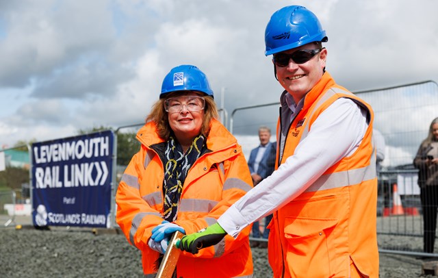
Fiona Hyslop, Transport Minister, has visited and fitted the last rail clip, according to the Facebook page.
And this will be a further automerge.
Transport Scotland and Network Rail now both have press releases about today's events.
 www.transport.gov.scot
 www.networkrailmediacentre.co.uk
Notice the latest wording on electrification: "Installation of infrastructure to enable future electrification of the line".
Closure dates announced for Levenmouth railway crossings
Network Rail is advising communities along the route of the Levenmouth line that crossing points over the railway will close at the end of the month.
Network Rail is advising communities along the route of the Levenmouth line that crossing points over the railway will close at the end of the month.
The permanent closures, from August 31, include at a number of former paths and historic rights of way which have been legally extinguished and are no longer open to the public.
Crossing point closures include at Waukmill, Doubledykes and Durievale and all will be fenced-off to secure the railway.
It is no longer safe to allow public access as sections of the track are now complete and are part of the operational railway – carrying engineering trains to support the ongoing construction of the line.
There will also be temporary restrictions at Duniface, Methilhill and Mountfleurie during the construction of new bridges over the line at these locations.
Proposals for the new bridges are currently going through planning consent and dates when temporary closures will be in place to enable their construction will be confirmed following that process.
The majority of the crossing point closures will be permanent, but the three new bridges on the route will maintain connections between communities, improve access to the line’s new stations at Leven and Cameron Bridge and play an integral part in the enhanced active travel network in the area.
The bridges will provide safe access over the new £116m Scottish Government-funded railway, which will connect Levenmouth to the rail network for the first time in more than 50 years when it opens in 2024.
When complete, the new line will create a direct link with Edinburgh across 10kms of new track and deliver two new stations for the community.
Joe Mulvenna, Network Rail’s project manager for the Levenmouth Rail Link project, said: “With significant work ongoing across the route to deliver the stations, signalling and bridges limiting access is now unavoidable as securing the railway boundary will protect the safety of the public.
“The most effective way of reducing level crossing risk on the railway is to remove crossings and we do not design them into new railways.
“The development of the rail link and associated active travel enhancements has given us the opportunity to reduce the number of crossings and replace some core paths and well-used walking routes with the new bridges which we are building on behalf of Fife Council.”
Notes to Editors
Crossing points at Balgonie, Doubledykes, Waulkmill, Tullybreck and Durievale will close permanently on August 31.
Crossing points and pathways at Methilhill, Duniface (x2) and Mountfleurie will remain open until planning consents have been received and work to construct new bridges gets underway.
---------------- This will be no doubt be automerged with the above.
Fife Today has this to say on the crossing closures:
Leven rail link: Network Rail face backlash over plan to close historic crossings
Plans to permanently close historic crossing over a rail line as part of the work on the new Levenmouth line have sparked a huge backlash.
Plans to permanently close historic crossing over a rail line as part of the work on the new Levenmouth line have sparked a huge backlash.
Allan Crow
By Allan Crow
Published 21st Aug 2023, 21:25 BST- 3 min read
Updated 22nd Aug 2023, 14:41 BST
Network Rail has been condemned by an MSP who said it was “almost as if they're trying to cause friction between communities.” Peter Grant is now seeking an urgent meeting with Màiri McAllan, Scottish Transport Minister when she visits the railway later this week.
And Thornton Community Council, which has fought to save the DoubleDykes crossing, has warned that if no replacement is provided, the £116m Levenmouth rail project will “leave a bitter legacy for the people and communities of Fife” - and “show that those involved in scoping the project do not know or care for the area.”
The angry responses came within hours of Network Rail’s announcement that it will close and fence off permanently the points at Waukmill, Doubledykes and Durievale as part of its work to complete the project that will put Leven back on the rail network for the first time in 50 years. The move takes effect from August 31.
The community council has pushed to save the historic Doubledykes crossing between the town Coaltown of Balgonie and the Wemyss area, arguing it is well used by cyclists and walkers. Network Rail said the former paths and historic rights of way have been legally extinguished and are no longer open to the public – a claim disputed by the council - and it said it was no longer safe to allow public access as sections of the track are now complete and are part of the operational railway, carrying engineering trains to support the ongoing construction work.
But that sparked an angry response from Peter Grant, MSP for Glenrothes. He said: “We've seen some crassly insensitive stuff from Network Rail over their threat to close three rights of way on the western half of the Levenmouth Rail Link but this really does take the biscuit.
“In the same email that they confirm they intend to "permanently" close all three public routes next week, having previously said there's no money for even one bridge to maintain public access, they also confirm they've started the process of putting in three new bridges further east. It's almost as if they're trying to cause friction between communities a few miles apart. I've asked for an urgent meeting with Scottish Transport Minister when she visits the railway later this week.”
Thornton Community Council said it would continue to fight to save the crossing.
In a statement, it said: “If no crossing is provided at DoubleDykes the Levenmouth Rail Project will leave a bitter legacy for the people and communities of Fife, particularly the wider Glenrothes area. It will show that those involved in scoping the project, including Fife Council, do not know or care for the area, people or communities they are in the service of and do not authentically consult or engage with them. This even applies to engaging their community councils. It also suggests that the Scottish Government is happy for Scotland's access rights to be defined by Network Rail.”It also said it would scrutinise a number of decisions made in respect of DoubleDykes in the course of the rail project.
“We don't believe it is too late and hold out hope for our politicians intervening, or that someone at Fife Council or the Scottish Government will do the right thing.”
This will be automerged too.
Fiona Hyslop, Transport Minister, has visited and fitted the last rail clip, according to the Facebook page.
And this will be a further automerge.
Transport Scotland and Network Rail now both have press releases about today's events.
Transport Minister marks significant milestone on Leven rail link | Transport Scotland
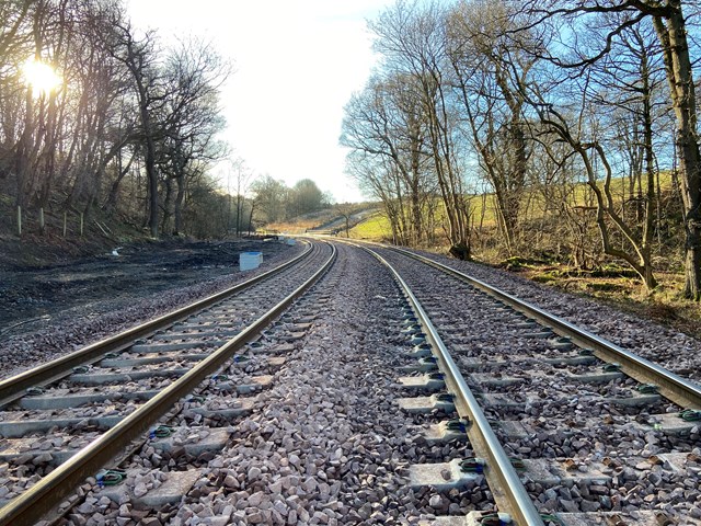
The Levenmouth rail link reached a significant milestone today as Transport Minister, Fiona Hyslop, installed the final clip in the new track.
The project includes two brand new stations and 19 kilometres of track, laid over several phases since March 2022, connecting Leven to Thornton Junction on the East Coast Mainline with passenger trains for the first time in more than five decades.
The £116 million project, funded by the Scottish Government and scheduled for completion on time in 2024, will also see preparatory work to enable the electrification as part of wider ambitions to decarbonise Scotland’s Railway.
Ms Hyslop said:
“It is fantastic to be here today to meet the site team and mark the completion of track laying on the project. It demonstrates what can be delivered through the excellent teamwork and determination that has made this possible.
“With work progressing on both Leven and Cameron Bridge stations, it is great to see a real and growing sense of excitement and anticipation building around the project, particularly in the surrounding communities regarding the social and economic benefits that the new line will bring.
“I would like to thank the team on the ground who worked through all weathers to complete the track and continue to work hard to bring this line back to life. On completion, the line will enable low-carbon transport options and make a real contribution to the Government’s net-zero transport ambitions.”
Alex Hynes, managing director of Scotland’s Railway said:
“It’s a privilege to be able to welcome the Minister to the site of the new Leven station to mark the completion of track laying on the Levenmouth Rail Link.
“The new line will reconnect local communities to the railway for the first time in more than five decades and it is incredible to see the progress the project team has made on the track work over the past year.
“Our focus now turns towards the completion of the new stations on the route ahead of the line entering passenger service next year.
“We are incredibly proud to be delivering this project on behalf of the Scottish Government and helping to unlock the leisure, education and employment opportunities that the new railway will deliver.”
Completion of track installation marks a significant milestone on the Scottish Government-funded project and brings the prospect of the reintroduction of passenger services on the line ever closer.
The programme is scheduled to complete in Spring 2024.
Transport Minister welcomes completion of track work at Leven
Scotland’s Transport Minister, Fiona Hyslop, has today installed the final pandrol clip to mark completion of track laying on the Levenmouth Rail Link project.
Scotland’s Transport Minister, Fiona Hyslop, has today installed the final pandrol clip to mark completion of track laying on the Levenmouth Rail Link project.
Completion of track installation marks a significant milestone on the £116m Scottish Government-funded project which will reconnect Levenmouth, in Fife, to the passenger rail network for the first time in more than 50 years.
The 19 kilometres of track, laid over a number of phases since March 2022, connects Leven to Thornton Junction on the East Coast Mainline.
Since the start of work on the line, the track bed has been dug out with 80,000 tonnes of spoil removed. The ground has been waterproofed and approximately 75,000 tonnes of new stone ballast laid.
Engineers have installed more than 29,000 sleepers and 35km of rail in 165, 215-metre-long sections to complete the new track.
Scheduled for completion in 2024, the project will also see preparatory work to enable the future electrification of the line as part of wider ambitions to decarbonise Scotland’s Railway.
Ms Hyslop said: “It is fantastic to be here today to meet the site team and mark the completion of track laying on the project. It demonstrates what can be delivered through the excellent teamwork and determination that has made this possible.
“With work progressing on both Leven and Cameron Bridge stations, it is great to see a real and growing sense of excitement and anticipation building around the project, particularly in the surrounding communities regarding the social and economic benefits that the new line will bring.
“I would like to thank the team on the ground who worked through all weathers to complete the track and continue to work hard to bring this line back to life. On completion, the line will enable low-carbon transport options and make a real contribution to the Government’s net-zero transport ambitions.”
Alex Hynes, managing director of Scotland’s Railway said: “It’s a privilege to be able to welcome the Minister to the site of the new Leven station to mark the completion of track laying on the Levenmouth Rail Link.
“The new line will reconnect local communities to the railway for the first time in over five decades and it is incredible to see the progress the project team has made on the track work over the past year.
“Our focus now turns towards the completion of the new stations on the route ahead of the line entering passenger service next year.
“We are incredibly proud to be delivering this project on behalf of the Scottish Government and helping to unlock the leisure, education and employment opportunities that the new railway will deliver.”
Notes to Editors
Levenmouth Rail Link updates
Following successful completion of a range of preparatory activities the project to deliver the new Levenmouth Rail Link kicked off in March 2022.
Work includes:
19 single track kilometres of new / reinstated railway. (Fully double tracked railway)
Two new modern accessible stations
Installation of infrastructure to enable future electrification of the line
Work with partners to optimise interchange options connecting stations.
The project is a £116.6m Scottish Government investment.
The programme is scheduled to complete in Spring 2024.
Current Status:
Current work across the route includes fencing, signalling, drainage and cabling works.
Preparatory activity is underway at Dunniface, Methil and Mountfleurie to construct bridges across the railway to maintain connections between communities and enhance the active travel network in conjunction with Fife Council.
Work is now underway on both Cameron Bridge and Leven stations.
Work on the (Bawbee) Leven bridge is significantly advanced as we work towards installing the bridge deck and reinstating the carriageway
Planning consents for both station developments on the line have now been secured.
Notice the latest wording on electrification: "Installation of infrastructure to enable future electrification of the line".
Last edited:
- Status
- Not open for further replies.